Indre Arna

Last updated
Indre Arna
Neighborhood in Bergen
Fra Adnanipa mot Ytre Arna.JPG
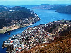
View of the neighborhood with Ådnanipa in Indre Arna in the foreground
Norway Vestland adm location map.svg
Red pog.svg
Indre Arna
Location of the neighborhood
Norway location map.svg
Red pog.svg
Indre Arna
Indre Arna (Norway)
Coordinates: 60°25′04″N5°28′15″E / 60.4177°N 5.4709°E / 60.4177; 5.4709 Coordinates: 60°25′04″N5°28′15″E / 60.4177°N 5.4709°E / 60.4177; 5.4709
Country Norway
Region Western Norway
County Vestland
Municipality Bergen
Borough Arna
Area
  Total3.96 km2 (1.53 sq mi)
Elevation
[1]
38 m (125 ft)
Population
 (2012)
  Total6,536
  Density1,651/km2 (4,280/sq mi)
Time zone UTC+01:00 (CET)
  Summer (DST) UTC+02:00 (CEST)

Indre Arna is a suburban village in the borough of Arna in the municipality of Bergen in Vestland county, Norway. While Indre Arna is relatively far from most of the city centre by road, there is an 8-minute train journey through the mountain Ulriken from Indre Arna to the city centre. Arna Church is located in the village.

The 3.96-square-kilometre (980-acre) village has a population (2012) of 6,536 and a population density of 1,651 inhabitants per square kilometre (4,280/sq mi). [2] Since 2013, Statistics Norway no longer tracked separate population statistics for Indre Arna, instead the village was incorporated into a larger urban area called Arna. [3]

Related Research Articles

Etne Municipality in Vestland, Norway

Etne is a municipality in Vestland county, Norway. It is located in the traditional district of Sunnhordland, although it is also sometimes considered to be part of the district of Haugaland. The administrative centre of the municipality is the village of Etnesjøen. Other villages in the municipality include Skånevik and Fjæra. The two largest villages in the municipality are Etnesjøen with 1,159 residents and Skånevik with 594 residents.

Ulvik Municipality in Vestland, Norway

Ulvik is a municipality in Vestland county, Norway. The municipality stretches from the Hardangerfjord to the mountains that reach 1,800 metres (5,900 ft) above sea level. The administrative centre of the municipality is the village of Ulvik. The villages of Osa and Finse are also located in Ulvik municipality.

Samnanger Municipality in Vestland, Norway

Samnanger is a municipality in the Midhordland region of Vestland county, Norway. The administrative centre of the municipality is the village of Tysse. Other main villages in the municipality include Haga and Bjørkheim in Nordbygda. The municipality is located about 20 kilometres (12 mi) east of the city of Bergen, Norway's second largest city. It surrounds the inner part of the Samnangerfjorden and the surrounding valleys. There are mountains that surround the municipality. The development of hydroelectric power plants started here in 1909.

Vaksdal Municipality in Vestland, Norway

Vaksdal  is a municipality in the county of Vestland, Norway. It is located in the traditional district of Nordhordland. The administrative centre is the village of Dalekvam. Other villages in Vaksdal include Dalegarden, Flatkvål, Helle, Nesheim, Stamneshella, Stanghelle, and Vaksdal.

Osterøy Municipality in Vestland, Norway

Osterøy is an island municipality in Vestland county, Norway. It is located in the traditional district of Nordhordland. The municipality encompasses most of the island of Osterøy. The administrative centre of Osterøy is the village of Lonevåg in the central part of the island. The largest settlement is the village of Valestrandfossen with 1,219 inhabitants as of 1 January 2016.

Arna, Norway Borough in Western Norway, Norway

Arna is a borough in the city of Bergen in Vestland county, Norway. It is one of eight boroughs in Bergen. It encompasses the northeastern part of the municipality of Bergen. Arna was merged into the city of Bergen in 1972. Prior to that, it was the separate municipality of Arna. The main population centres in the borough are the villages of Indre Arna, Ytre Arna, and Espeland.

Flesland is a village in the borough of Ytrebygda in the municipality of Bergen in Vestland county, Norway. It sits on the western coast of the Bergen Peninsula, about 13 kilometres (8.1 mi) southwest of the city centre of Bergen. It is the site of Bergen Airport, Flesland and Flesland Air Station.

Espeland Neighborhood in Bergen in Vestland, Western Norway, Norway

Espeland is a village in the borough of Arna in the municipality of Bergen in Vestland county, Norway. Espeland is located north of Lake Haukeland and Mount Livarden. The village of Indre Arna lies about 4 kilometres (2.5 mi) to the north.

Tunes is a suburban village in the borough of Arna in the municipality of Bergen in Vestland county, Norway. It is a part of the urban area of Arna, which has a population of 9,744.

Krokeidet Neighborhood in Bergen in Vestland, Western Norway, Norway

Krokeidet is a suburban village in the borough of Fana in the municipality of Bergen in Vestland county, Norway. It is located near the end of a small peninsula between the Lysefjorden and Fanafjorden, about 20 kilometres (12 mi) south of the city centre of Bergen. The 0.54-square-kilometre (130-acre) village has a population (2019) of 393 and a population density of 72 inhabitants per square kilometre (190/sq mi).

Hylkje Neighborhood in Bergen in Vestland, Western Norway, Norway

Hylkje is a village in the borough of Åsane in the municipality of Bergen in Vestland county, Norway. The village lies in the northeastern part of the municipality, along the Sørfjorden. The European route E39 runs through Hylkje.

Osøyro Village in Western Norway, Norway

Osøyro is the administrative centre of Bjørnafjorden municipality in Vestland county, Norway. The village lies on the southwestern part of the Bergen Peninsula, along the western shore of the Fusafjorden, about 25 kilometres (16 mi) south of the city centre of Bergen. The European route E39 highway runs through the village on its way to Bergen. There is a car ferry from the east side of Osøyro to the village of Fusa, across the Fusafjorden. Os Church is located in the village.

Søvik is a village in the municipality of Bjørnafjorden in Vestland county, Norway. The village lies at the eastern end of the Lysefjorden, a short distance south of the city of Bergen. The area is notable for the ancient ruins of the Lyse Abbey, located on the northeast side of the village. The Lyshornet mountain lies about 3 kilometres (1.9 mi) north of the village.

Fanahammeren

Fanahammeren or Fanahammaren is a residential village area at the eastern end of the Fanafjorden in the city of Bergen in Vestland county, Norway. Fanahammeren lies about 15 kilometres (9.3 mi) south of the city centre.

Ytre Arna Neighborhood in Bergen in Vestland, Western Norway, Norway

Ytre Arna is a settlement in the borough of Arna in the municipality of Bergen in Vestland county, Norway. Ytre Arna is principally associated with A/S Arne Fabrikker, the country's first mechanised cotton mill. Ytre Arna Church is also located in the village.

Hausvik Village in Western Norway, Norway

Haus or Hausvik is a village in Osterøy municipality in Vestland county, Norway. The village is located on the southwestern coast of the island of Osterøy along the Sørfjorden. The village lies across the Sørfjorden from the villages of Ytre Arna and Garnes. The village of Valestrandfossen lies about 7 kilometres (4.3 mi) north along the fjord. The 0.37-square-kilometre (91-acre) village has a population (2019) of 601 and a population density of 1,624 inhabitants per square kilometre (4,210/sq mi).

Fana (municipality) Former municipality in Hordaland, Norway

Fana is a former municipality in the old Hordaland county in Norway. The municipality was located in the central part of the Bergen Peninsula, south of the city of Bergen. The administrative centre of the municipality was the village of Nesttun. The roughly 200-square-kilometre (77 sq mi) municipality existed from 1838 until 1972 when it had 44,402 residents, making it one of the most populous municipalities in the nation. The area of the former municipality encompassed the southern half of the present-day Bergen Municipality in Vestland county, it specifically included the present-day boroughs of Fyllingsdalen, Ytrebygda, and Fana, as well as the southern part of the borough of Årstad.

Søfteland or Syfteland is a village in Bjørnafjorden municipality in Vestland county, Norway. It lies on the Bergen Peninsula, along the European route E39 highway, about 6 kilometres (3.7 mi) north of the municipal centre of Osøyro and about 20 kilometres (12 mi) south of the city of Bergen. The mountain Møsnuken lies about 3.5 kilometres (2.2 mi) east of the village and the mountain Lyshornet lies about 2.3 kilometres (1.4 mi) west of the village. The 1-square-kilometre (250-acre) village has a population (2019) of 1,889 and a population density of 1,889 inhabitants per square kilometre (4,890/sq mi).

Laksevåg (municipality) Former municipality in Hordaland, Norway

Laksevåg is a former municipality in the old Hordaland county in Norway. The 32-square-kilometre (12 sq mi) municipality was located on the western part of the Bergen Peninsula. The administrative centre of the municipality was the village of Loddefjord. The municipality, which existed from 1918 until 1972, was a located a short distance west of the city of Bergen, and today it makes up the borough of Laksevåg which is part of the city of Bergen in Bergen Municipality which is now in Vestland county. The municipality was located along the Byfjorden, north of the Grimstadfjorden, and west of the Fyllingsdalen valley.

Arna (municipality) Former municipality in Hordaland, Norway

Arna is a former municipality in the old Hordaland county, Norway. The municipality existed from 1964 until 1972. It encompassed the northeastern part of the Bergen Peninsula, along the Sørfjorden, bordering the city of Bergen across the mountains to the west. The administrative centre of the municipality was the village of Indre Arna. The municipality stretched from the village of Ytre Arna to Trengereid along the coast and then inland about 8 kilometres (5.0 mi) to the Espeland area. Today, the area of the former municipality makes up the borough of Arna in the city of Bergen.

References

  1. "Indre Arna, Bergen (Vestland)". yr.no . Retrieved 17 June 2020.
  2. Statistisk sentralbyrå (1 January 2019). "Urban settlements. Population and area, by municipality".
  3. Statistisk sentralbyrå (1 January 2013). "Nye og utgåtte tettsteder" (in Norwegian).