Cuddalore, also spelt as Kadalur, is the city and headquarters of the Cuddalore District in the Indian state of Tamil Nadu. Situated south of Chennai, Cuddalore was an important city and port during the British Raj.
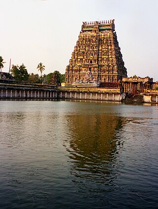
Chidambaram is a town and municipality in Cuddalore district in the Indian state of Tamil Nadu, on the banks of the Vellar River where it meets the Bay of Bengal. It is the headquarters of the Chidambaram taluk. The town is believed to be of significant antiquity and has been ruled, at different times, by the Pallavas until ninth century, Medieval Cholas, Later Cholas, Later Pandyas, Vijayanagara Empire, Thanjavur Nayakas, Marathas and the British. The town is known for the Thillai Nataraja Temple and Thillai Kali Temple, and the annual chariot festival held in the months of December–January and June to July. One of the Divya Desams Divya Sri Govindaraja Perumal Temple (Thiruchitrakoodam) is a part of Thillai Nataraja Temple complex. Thiruvetkalam Shiva Temple, Vadakiruppu, Thirunelvayil Shiva Temple, Sivapuri and Tirukkazhippalai Palvannanathar Temple are the other three ancient Shiva temples in the region.

Perambalur is one of the 38 districts in the state of Tamil Nadu, India. The district headquarters is located at Perambalur. The district occupies an area of 1,752 km2 and had a population of 565,223 with a sex-ratio of 1,003 females for every 1,000 males in 2011.

Tiruvallur is a Grade I municipality in the Indian state of Tamil Nadu. It is located on the banks of Coovum river about 46 km (29 mi) from downtown Chennai (Madras) and just 5 km from megacity border, in the western part of the Chennai Metropolitan Area (CMA). It is a satellite town of Chennai and is the administrative headquarters of Tiruvallur district. The city is known for the Veera Raghavar temple, one of the 108 sacred shrines of Vaishnavites. The tank festival is held at a pond near this temple. A Shiva temple near this shrine which is popular among the locals. There is also a 40-foot (12 m) tall Viswaroopa Panchamukha Hanuman temple, where the murti is made of a single green granite stone.
Panruti is a developing city, municipality and taluk headquarters of Cuddalore district, Tamil Nadu, India. Panruti is located between Cuddalore and Neyveli. Panruti is famous for jackfruits and cashew nuts. The jackfruit grown here is exported worldwide and is very sweet. It is a business capital of Cuddalore district. Kananchavadi one of the villages in panruti taluk, famous for palm juice. It has been a great commercial area for more than 200 years. The name Panruti came from the Tamil words "Pann" and "Urutti" meaning "composing song and music", as the place is where many saints and great religious singers such as nayanmars and vainavas sung. A 150-year-old government school was built here by the British East India Company and a more-than-1000-year-old temple Veerattaneswarar temple is nearby in Thiruvathigai. As of 2011, the town had a population of 60,323.

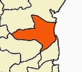
Cuddalore District is one of the 38 districts in the state of Tamil Nadu in India.
Annamalai Nagar is a special grade Panchayat town in Cuddalore district in the state of Tamil Nadu, India. The town is named after Annamalai Chettiar, an Indian businessperson, educationist and philanthropist. The Annamalai University, founded by him, is located in Annamalai Nagar.
Gangavalli is a panchayat town in Salem district in the state of Tamil Nadu, India.
Kattumannarkoil is a panchayat town and taluk headquarters in Cuddalore district in the Indian state of Tamil Nadu. Kattumannarkoil Town Panchayat constituted in 1892. The town is coming under the administrative territory of Cuddalore District. The town extends over an area of 19.425 km2. The town is situated along 25 km South West of Chidambaram and lies on the Chidambaram - Coimbatore Highway and 25 km East of Srimushnam and a similar distance north-east of Gangaikonda Cholapuram. The entire road route from Sethiathoppu to Kattumannarkoil runs alongside the Veeranam Lake. The newly built Muttam bridge provides connectivity to Mayladuthurai in the south at the distance of 30 km.
Kurinjipadi is a taluk in Cuddalore district in the India, state of Tamil Nadu.
Lalgudi is a town in Tiruchirapalli district in the Indian state of Tamil Nadu. The town of Lalgudi heads the Lalgudi taluk, Lalgudi division, Lalgudi Educational District, Lalgudi DSP and Lalgudi Constituency.
Periya Negamam is a panchayat town in Coimbatore district in the southern Indian State of Tamil Nadu. It comes under Pollachi Taluk and pollachi Assembly constituency. Negamam used to be a popular small town serving the commercial and transport needs of many small villages around it until 1980s. With the arrival of frequent city buses to Pollachi and Udumalpet as transportation mode, growth of Negamam remained stunted. Weekly market on Tuesday used to be a big crowd puller.
Thiruvidaimarudur is a panchayat town in Thanjavur district, in the Indian state of Tamil Nadu. The town is notable for its Mahalingeshwarar Temple, a Hindu shrine for Lord Shiva.

Vadalur is a municipality in Cuddalore district, Tamil Nadu. It is 208 km (129 mi) from Chennai, the state capital of Tamil Nadu.
Paramathi Velur, a town in Paramathi-Velur taluk, Namakkal District, Tamil Nadu, India is situated just off the Srinagar - Kanyakumari National Highway 44 (India). This town is also called as Paramathi Velur, with STD Code 04268 & Postal code 638182.
Arani, officially spelled as Arni and also known as Periya arani, is a major commercial, industrial and cultural hub and also a divisional headquarter in the Tiruvanamalai district of Tamil Nadu, India. The town is the second largest urban center next to the district headquarters, Tiruvannamalai, and is administered by a selection grade municipality. Arni is home to silk weaving, spinning mills and agricultural industries. Famous Arni silk and a paddy variety named Arni Ponni, known for its rich aroma, originates from Arni. The town is often nicknamed as The Silk City. Arni also has a rich cultural heritage as it is a major center of Tamil Jainism.
Chidambaram is a Lok Sabha constituency in Tamil Nadu. Its Tamil Nadu Parliamentary Constituency number is 27 of 39. The seat is reserved for scheduled castes. It spread on district of Ariyalur and Cuddalore.
Anniyur is a village located in the District of Viluppuram in the southern state of Tamil Nadu under the Union of India. It lies 25 kilometres from Gingee, Vilupuram
Chidambaram taluk is a taluk of Cuddalore district of the Indian state of Tamil Nadu. The headquarters of the taluk is the town of Chidambaram.Chidambaram is one of the many temple towns in the state which is named after the grooves, clusters or forests dominated by a particular variety of a tree or shrub and the same variety of tree or shrub sheltering the presiding deity. The town used to be called Thillai, following Thillaivanam, derived from the mangrove of Tillai trees that grow here and the nearby Pichavaram wetlands.
Rayanallur village is situated on the banks of the veeranam lake in North Chidambaram town, Cuddalore District in the state of Tamil Nadu.