Billtown, Indiana

Last updated

Billtown
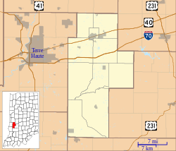
Location map of Clay County, Indiana.svg
Red pog.svg
Billtown
Location in Clay County
Coordinates: 39°30′36″N87°11′10″W / 39.51000°N 87.18611°W / 39.51000; -87.18611
Country United States
State Indiana
County Clay
Township Posey
Elevation
623 ft (190 m)
ZIP code
47834
FIPS code 18-05284 [1]
GNIS feature ID431086 [2]

Billtown is an unincorporated community in Posey Township, Clay County, Indiana. It is part of the Terre Haute Metropolitan Statistical Area.
Contents

History

Billtown was originally known as Williamstown, and under the latter name was platted in 1831. [3]

Billtown once contained a post office under the name Van Buren. [4] The Van Buren post office operated from 1835 until 1865. [5]

Geography

Billtown is located at 39°30′36″N87°11′10″W / 39.51000°N 87.18611°W / 39.51000; -87.18611 .

Demographics

The United States Census Bureau delineated Billtown as a census designated place in the 2022 American Community Survey. [6]

Related Research Articles

<span class="mw-page-title-main">Carbon, Indiana</span> Town in Indiana, United States

Carbon is a town in Van Buren Township, Clay County, Indiana, United States. The population was 397 at the 2010 census. It is part of the Terre Haute Metropolitan Statistical Area.

<span class="mw-page-title-main">Knightsville, Indiana</span> Town in Indiana, United States

Knightsville is a town in Van Buren Township, Clay County, Indiana, United States. The population was 872 at the 2010 census. It is part of the Terre Haute Metropolitan Statistical Area.

<span class="mw-page-title-main">Van Buren Township, Michigan</span> American township in Michigan

Van Buren Township is a charter township in Wayne County in the U.S. state of Michigan. A western suburb of Detroit, Van Buren Township is located roughly 28 miles (45.1 km) southwest of downtown Detroit, and 17 miles (27.4 km) southeast of Ann Arbor. As of the 2020 census, the township had a population of 30,375. It surrounds, but is independent of, the city of Belleville.

<span class="mw-page-title-main">Van Buren Township, Monroe County, Indiana</span> Township in Indiana, United States

Van Buren Township is one of eleven townships in Monroe County, Indiana, United States. As of the 2010 census, its population was 11,981 and it contained 5,347 housing units.

<span class="mw-page-title-main">Cass, Indiana</span> Unincorporated community in Indiana, United States

Cass is an unincorporated community in Cass Township, Sullivan County, in the U.S. state of Indiana.

<span class="mw-page-title-main">Burnett, Indiana</span> Unincorporated community in Indiana, United States

Burnett is an unincorporated community in Otter Creek Township, Vigo County, in the U.S. state of Indiana.

<span class="mw-page-title-main">Elkinsville, Indiana</span> Unincorporated community in Indiana, United States

Elkinsville is an unincorporated community in Van Buren Township, Brown County, in the U.S. state of Indiana. It was once a thriving farming village, but was evacuated during the construction of nearby Lake Monroe Reservoir by eminent domain in 1964. All that remains of Elkinsville today are some private residences, the Elkinsville Cemetery, and post office. The area is part of Hoosier National Forest.

<span class="mw-page-title-main">Art, Indiana</span> Unincorporated community in Indiana, United States

Art is an unincorporated community in Perry Township, Clay County, Indiana. It is part of the Terre Haute Metropolitan Statistical Area.

Ashboro is an unincorporated community in Sugar Ridge Township, Clay County, Indiana. It is part of the Terre Haute Metropolitan Statistical Area.

Asherville is an unincorporated community in Jackson Township, Clay County, Indiana. It is part of the Terre Haute Metropolitan Statistical Area.

Cardonia is an unincorporated community in Van Buren Township, Clay County, Indiana. It is part of the Terre Haute Metropolitan Statistical Area.

<span class="mw-page-title-main">Cloverland, Indiana</span> Unincorporated community in Indiana, United States

Cloverland is an unincorporated community in Posey Township, Clay County, Indiana. It is part of the Terre Haute Metropolitan Statistical Area.

<span class="mw-page-title-main">Coalmont, Indiana</span> Census-designated place in Indiana, United States

Coalmont is an unincorporated community and census-designated place in Lewis Township, Clay County, Indiana, United States. It is part of the Terre Haute Metropolitan Statistical Area. As of the 2010 census, it had a population of 402.

<span class="mw-page-title-main">Cory, Indiana</span> Unincorporated community in Indiana, United States

Cory is an unincorporated community in Perry Township, Clay County, Indiana. It is part of the Terre Haute Metropolitan Statistical Area. Cory hosts the annual Cory Apple Festival.

Hoosierville is an unincorporated community in Jackson Township, Clay County, Indiana. It is part of the Terre Haute Metropolitan Statistical Area.

Howesville is an unincorporated community in Lewis Township, Clay County, Indiana. It is part of the Terre Haute Metropolitan Statistical Area.

Perth is an unincorporated community in Dick Johnson Township, Clay County, Indiana. It is part of the Terre Haute Metropolitan Statistical Area.

<span class="mw-page-title-main">Saline City, Indiana</span> Unincorporated community in Indiana, United States

Saline City is an unincorporated community in Sugar Ridge Township, Clay County, Indiana. It is part of the Terre Haute Metropolitan Statistical Area.

<span class="mw-page-title-main">Raglesville, Indiana</span> Census-designated place in Indiana, United States

Raglesville is an unincorporated community and census-designated place (CDP) in Van Buren Township, Daviess County, Indiana, United States. As of the 2010 census it had a population of 141.

<span class="mw-page-title-main">Shepardsville, Indiana</span> Census-designated place in Indiana, United States

Shepardsville is an unincorporated census-designated place in northeastern Fayette Township, Vigo County, in the U.S. state of Indiana. It lies along Trinity Ave. north of the city of Terre Haute, the county seat of Vigo County. Its elevation is 502 feet (153 m), and it is located at 39°36′3″N87°25′3″W. Although Shepardsville is unincorporated, it has a post office, with the ZIP code of 47880.

References

  1. "U.S. Census website". United States Census Bureau . Retrieved January 31, 2008.
  2. "Billtown, Indiana". Geographic Names Information System . United States Geological Survey, United States Department of the Interior . Retrieved October 10, 2009.
  3. Blanchard, Charles (1884). Counties of Clay and Owen, Indiana: Historical and Biographical. F.A. Battey & Company. pp.  33.
  4. Baker, Ronald L. (October 1995). From Needmore to Prosperity: Hoosier Place Names in Folklore and History . Indiana University Press. p.  67. ISBN   978-0-253-32866-3.
  5. "Clay County". Jim Forte Postal History. Retrieved August 30, 2014.
  6. "2022 Geography Changes". United States Census Bureau.