Cilacap Regency is a regency in the southwestern part of Central Java province in Indonesia. Its capital is the town of Cilacap.
Sampang Regency is a regency of East Java province, Indonesia. It is situated on Madura Island, bordering on Pamekasan Regency to the east, the Java Sea to the north, Bangkalan Regency to the west, and Madura Strait to the south. It covers an area of 1,228.25 km2, and had a population of at the 2010 census 877,772 and at the 2020 census 969,694; the official estimate as of mid-2023 was 988,360 - comprising 488,900 males and 499,460 females. The administrative centre is the port of Sampang, on the south coast of Madura.
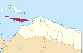
Bomberai Peninsula is located in the Western New Guinea region. It is south of the Bird's Head Peninsula, and Bintuni Bay separates the two peninsulas. To the west lies the Sebakor Bay and to the south Kamrau Bay. On the southeast Arguni Bay lies between the peninsula and the Bird's Neck Isthmus.

East Kutai Regency is a regency of East Kalimantan province, Indonesia. It has an area of 35,747.50 km2 and had a population of 253,904 at the 2010 census and 434,459 at the 2020 census; the official estimate as at mid 2022 was 425,613. The town of Sangatta is the capital of the regency.

Supiori Regency is a regency in the Indonesian province of Papua. The Regency has an area of 634.24 km2 including the Aruri Islands group to the south, and had a population of 15,874 at the 2010 Census and 22,547 at the 2020 Census; the official estimate as at mid 2022 was 23,247 - comprising 12,056 males and 11,191 females. Until 8 January 2004, this area was part of the Biak Numfor Regency, from which it was split off in accordance with the Law dated 18 December 2003.

Paniai Regency is one of the regencies (kabupaten) in Central Papua Province of Indonesia. It is named after the Paniai Lakes. It covers an area of 6,525.25 km2, and had a population of 153,432 at the 2010 Census and 220,410 at the 2020 Census; the official estimate as of mid-2022 was 227,254 - comprising 124,260 males and 102,994 females. The administrative centre is the town of Enarotali, in East Paniai.

Mimika Regency is one of the regencies (kabupaten) in the Indonesian province of Central Papua. It covers an area of 21,693.51 km2, and had a population of 182,001 at the 2010 Census, but grew to 311,969 at the 2020 Census. The official estimate as of mid-2022 was 321,657. The administrative centre is the town of Timika, which lies within Mimika Baru District, which had 144,893 inhabitants in mid-2021.
Yapen Islands Regency is a regency (kabupaten) in Papua Province of eastern Indonesia. It covers an area of 2,432.49 km2 (939.19 sq mi), and had a population of 82,951 at the 2010 Census and 112,676 at the 2020 Census; the official estimate as at mid 2022 was 116,107. It comprises an archipelago which lies in Cenderawasih Bay off the north coast of Western New Guinea.

Dompu Regency is a regency of the Indonesian Province of West Nusa Tenggara. It is located on the island of Sumbawa and the capital is Dompu. It is bordered to the north and to the east by two non-contiguous parts of Bima Regency, and to the west by Sumbawa Regency, as well as on its coasts by Saleh Bay, Sanggar Bay, and Cempi Bay. It covers an area of 2,324.55 km2, and the population at the 2010 Census was 218,984 and at the 2020 Census was 236,665; the official estimate as at mid 2023 was 247,188.
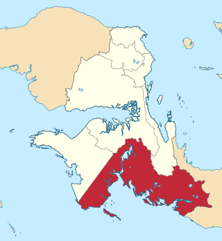
Bintuni is a small town and administrative district in West Papua, Indonesia and seat of the Teluk Bintuni Regency. It comprises two villages with a combined population of 13,795 at the 2010 Census. The town is located near the southeast coast of the Bird's Head Peninsula on Bintuni Bay. It is served by Steenkool Airport. The district had 24,742 inhabitants in 2018.
Kaimana Regency is a regency in the south of West Papua province of Indonesia. It covers an area of 18,500 sq. km, and had a population of 46,249 at the 2010 Census and 62,256 at the 2020 Census; the official estimate as at mid 2022 was 63,633. The administrative centre is the town of Kaimana. The Mairasi languages are spoken in the regency, among other languages.

Manokwari Regency is a regency in West Papua, Indonesia. Following the splitting away of twenty of its former districts in 2013, it now covers an area of 3,168.28 km2 and had a population of 192,663 at the 2020 Census; the official estimate as at mid 2022 was 200,785. The administrative centre is presently at the town of Manokwari, which is also the capital of the province, but under proposals currently under consideration by the Indonesian Parliament, the town is intended to be split off from the regency to form a separate independent city.

Maybrat Regency is a regency of Southwest Papua Province of Indonesia. It has an area of 5,461.69 km2 (2,108.77 sq mi), and had a population of 33,081 at the 2010 Census and 42,991 at the 2020 Census; the official estimate as at mid 2022 was 44,812. The administrative centre is the town of Kumurkek, in Aifat District. The Maybrat language is spoken in the regency.

Raja Ampat Regency is a regency of Southwest Papua Province of Indonesia. The regency, which was formed by separating the archipelago from Sorong Regency, based on the Law 26 of 2002, was inaugurated on 12 April 2003. It consists of a number of groups of islands situated off the north-west end of West Papua; the four main islands from south to north are Misool, Salawati, Batanta, and Waigeo. At present, the regency covers a land area of 7,559.60 km2, with a total area stated as 67,379.61 km2. It had a population of 42,508 at the 2010 Census and 64,141 at the 2020 Census; the official estimate as at mid 2022 was 66,839. The principal town lies at Waisai on Waigeo Island.

South Sorong Regency is a regency of Southwest Papua province of Indonesia. It has an area of 6,594.31 km2, and had a population of 37,900 at the 2010 Census and 52,469 at the 2020 Census; the official estimate as at mid 2022 was 53,884. The administrative centre is the town of Teminabuan.

Tambrauw Regency is a regency of Southwest Papua Province, Indonesia, in the Bird's Head Peninsula of Papua Island. It was created on 29 October 2008 from what had been an eastern part of Sorong Regency, originally as part of the province of West Papua.
Teluk Wondama Regency or Wondama Bay Regency is a regency of West Papua province of Indonesia. The Regency contains several coastal districts in Wondiboy Peninsula but also including a number of islands in the southwest part of Cenderawasih Bay. It covers a land area of 4,843.99 km2, and had a population of 26,321 at the 2010 Census and 41,644 at the 2020 Census; the official estimate as at mid 2022 was 43,746. The administrative centre lies in the village of Rasiei.
West Seram Regency is a regency of Maluku, Indonesia. It is mainly located on Seram, but includes various islands lying to the west of Seram -- Manipa, Kelang, Boano, as well as the smaller islets of Babi, Pua, Masowoi, and Marsegu. It covers a land area of 6,948.40 km2, and had a population of 164,654 at the 2010 Census and 212,393 at the 2020 Census; the official estimate as at mid 2023 was 214,979. The principal town lies at Piru, a port at the northern coast of Latira Bay which almost separates the Huamual Peninsula from the rest of Seram Island. The western sector of the Regency occupies just under 25% of the land area, but held over 42% of the Regency's population at the 2020 Census.

South Manokwari Regency is a regency of West Papua Province of Indonesia. It was formed in 2013 from the southern districts of Manokwari Regency. The population of the area now comprised in the new regency was 18,564 at the 2010 Census, which rose to 35,949 at the 2020 Census; the official estimate as at mid 2022 was 38,648. The administrative centre is the town of Ransiki.