
The Regional Municipality of York, also called York Region, is a regional municipality in Southern Ontario, Canada, between Lake Simcoe and Toronto. The region was established after the passing of then Bill 102, An Act to Establish The Regional Municipality of York, in 1970. It replaced the former York County in 1971, and is part of the Greater Toronto Area and the inner ring of the Golden Horseshoe. The regional government is headquartered in Newmarket.
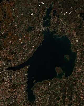
Lake Simcoe is a lake in southern Ontario, Canada, the fourth-largest lake wholly in the province, after Lake Nipigon, Lac Seul, and Lake Nipissing. At the time of the first European contact in the 17th century the lake was called Ouentironk by the native Wendat/Ouendat (Huron) people. It was also known as Lake Taronto until it was renamed by John Graves Simcoe, the first Lieutenant-Governor of Upper Canada, in memory of his father, Captain John Simcoe of the Royal Navy. In Anishinaabemowin, the ancestral language of the First Nations living around this lake, namely Anishinaabek of Rama and Georgina Island First Nations, Lake Simcoe is called Zhooniyaang-zaaga'igan, meaning "Silver Lake".

The Don River is a watercourse in southern Ontario that empties into Lake Ontario, at Toronto Harbour. Its mouth was just east of the street grid of the town of York, Upper Canada, the municipality that evolved into Toronto, Ontario. The Don is one of the major watercourses draining Toronto that have headwaters in the Oak Ridges Moraine.

The Humber River is a river in Southern Ontario, Canada. It is in the Great Lakes Basin, is a tributary of Lake Ontario and is one of two major rivers on either side of the city of Toronto, the other being the Don River to the east. It was designated a Canadian Heritage River on September 24, 1999.

Bradford West Gwillimbury is a town in south-central Ontario, in the County of Simcoe in the Toronto Census Metropolitan Area on the Holland River. West Gwillimbury takes its name from the family of Elizabeth Simcoe, née Gwillim.

Georgina is a town in south-central Ontario, and the northernmost municipality in the Regional Municipality of York. The town is bounded to the north by Lake Simcoe. Although incorporated as a town, it operates as a township in which dispersed communities share a common administrative council. The largest communities are Keswick, Sutton and Jackson's Point. Smaller communities include Pefferlaw, Port Bolster, Roches Point, Udora and Willow Beach. The town was formed by the merger of the Village of Sutton, the Township of Georgina and the Township of North Gwillimbury in 1971 and incorporated in 1986. North Gwillimbury had previously been part of Georgina but became its own township in 1826. It took its name from the family of Elizabeth Simcoe, née Gwillim.

Simcoe County is located in the central portion of Southern Ontario, Canada. The county is just north of the Greater Toronto Area, stretching from the shores of Lake Simcoe in the east to Georgian Bay in the west. Simcoe County forms part of the Greater Golden Horseshoe area, a densely populated and industrialized region, centred on the Greater Toronto Area.

The Nottawasaga River is a river in Simcoe County and Dufferin County in Central Ontario, Canada. It is part of the Great Lakes Basin, and is a tributary of Lake Huron. The river flows from the Orangeville Reservoir in the town of Orangeville, Dufferin County, through the Niagara Escarpment and the Minesing Wetlands, the latter a wetland of international significance, and empties into Nottawasaga Bay, an inlet of Georgian Bay on Lake Huron, at the town of Wasaga Beach, Simcoe County.

The Petawawa River is a river in the Saint Lawrence River drainage basin in Nipissing District and Renfrew County in eastern and northeastern Ontario, Canada. The river flows from Algonquin Provincial Park to the Ottawa River at the town of Petawawa, and is only one of two major tributaries of the Ottawa River to flow completely free. The river's name comes from the Algonquian for "where one hears a noise like this", which refers to its many rapids.

The Barron River is a river in the Saint Lawrence River drainage basin in Nipissing District and Renfrew County, Ontario, Canada. It flows from Clemow Lake in northern Algonquin Provincial Park and joins the Petawawa River, whose southern branch it forms, in the municipality of Laurentian Hills, near the municipality of Petawawa.
The Lynn River is a fresh water river located in Norfolk County in Southwestern Ontario, Canada. It empties into Lake Erie at Port Dover.
Sturgeon River may refer to:

Sutton is a suburban community located nearly 2 km south of Lake Simcoe in Ontario, Canada. The community was formerly a village but is now part of the Town of Georgina after amalgamation with it and North Gwillimbury in 1971. The Black River runs on the north end of the downtown. Highway 48 goes just south of the downtown. Sutton has a population of just over 6,000 people. Sutton is located about 1 hour north of Toronto.
The East Holland River is a river in Ontario, Canada that is part of the Holland River watershed that empties into Cook's Bay in Lake Simcoe. The headwaters of the East Holland River rise in the Oak Ridges Moraine. The river runs generally north from the town of Newmarket, and through Holland Landing where it joins up with the West Holland River.

The Holland River is a river in Ontario, Canada, that drains the Holland River watershed into Cook's Bay, the southern extremity of Lake Simcoe. The river flows generally north, and its headwaters lie in the Oak Ridges Moraine. The Holland River watershed is approximately 600 square kilometres (230 sq mi), spanning an area that includes New Tecumseth, King Township, Newmarket, Aurora, East Gwillimbury, and Whitchurch-Stouffville. The river's watershed also contains the Holland Marsh, a fertile farmland region renowned for its vegetable production.
The Thames River is located in southwestern Ontario, Canada.

The Lake Simcoe Region Conservation Authority is a conservation authority established in 1951, and is among the oldest in the Canadian province of Ontario.
The Boyne River is a river in Simcoe County and Dufferin County in Central Ontario, Canada. It is part of the Great Lakes Basin, and is a left tributary of the Nottawasaga River. The rivers falls within the jurisdiction of the Nottawasaga Valley Conservation Authority.

The Beaver River is a river in Durham Region in Central Ontario, Canada. It is part of the Great Lakes Basin, and is a tributary of Lake Simcoe. The river's drainage basin is mostly in Durham Region with the remaining portion in the city of Kawartha Lakes; the entire watershed is under the auspices of the Lake Simcoe Region Conservation Authority.

The Lake Simcoe Junction Railway (LSJR) was a short-line narrow gauge railway in Ontario just north of Toronto. It branched off the Toronto and Nipissing Railway at Stouffville and ran 42 kilometres (26 mi) north to the town of Sutton and then beyond to the shore of Lake Simcoe where a large wharf was built. The presence of the railway helped the town of Jackson's Point form on the lakeside. The line serviced timber and agricultural shipping, but was more widely used for shipping ice cut from the lake in the winter, and allowing weekend day trips to the lake in the summer.

