 Blennerhasset village green
 Blennerhasset bridge and weir
 Road junction in Torpenhow
 Former Country Towns Mission Hall in Torpenhow
This article needs additional citations for verification .(June 2009) |
| Blennerhasset and Torpenhow | |
|---|---|
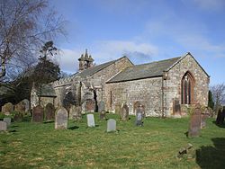 Church of St Michael and All Angels, Torpenhow | |
 Blennerhasset and Torpenhow Location within Cumbria | |
| Population | 423 (2011 census) |
| Civil parish |
|
| Unitary authority | |
| Ceremonial county | |
| Region | |
| Country | England |
| Sovereign state | United Kingdom |
| Police | Cumbria |
| Fire | Cumbria |
| Ambulance | North West |
Blennerhasset and Torpenhow is a civil parish in Cumbria, England. According to the 2001 census it had a population of 437, reducing to 423 at the 2011 Census. [1] It includes the villages of Blennerhasset grid reference NY178415 and Torpenhow at NY202397 and the smaller settlement of Kirkland Guards at NY187401 . It is located just outside the Lake District National Park. Baggrow railway station was immediately north of Blennerhasset. [2]
Contents

Location of Blennerhasset and Torpenhow
The local pronunciation of Torpenhow is trə-PEN-ə ( /trəˈpɛnə/ ⓘ ), rather than the more intuitive TOR-pən-how ( /ˈtɔːrpənhaʊ/ ). [3] [4] Blennerhasset is pronounced blen-RAY-sit ( /blɛnˈreɪsɪt/ ) instead of BLEN-ər-hass-it ( /ˈblɛnərhæsɪt/ ) as would be expected outside of Cumbria.
St Michael's Church, Torpenhow has a Norman chancel arch with a remarkable carving of interlocking human figures, and a painted wooden ceiling.


