Blowout, Texas

Last updated

Blowout
USA Texas location map.svg
Red pog.svg
Blowout
Location within the state of Texas
Usa edcp location map.svg
Red pog.svg
Blowout
Blowout (the United States)
Coordinates: 30°26′50″N98°34′39″W / 30.44722°N 98.57750°W / 30.44722; -98.57750
Country United States
State Texas
County Blanco
Elevation
1,263 ft (385 m)
Time zone UTC-6 (Central (CST))
  Summer (DST) UTC-5 (CDT)
GNIS feature ID1379432 [1]

Blowout is an unincorporated community in Blanco County, Texas, United States.

Contents

History

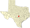
This community dates back to 1854 when a group of two-dozen homesteaders moved to the area from Kentucky and settled on the east side of Comanche Creek near Comanche Spring, about three miles below the origin of the creek. It began to grow into a community as more settlers arrived and moved upstream. The origin of the name "Blowout" is reported to be due to a bat guano explosion, when ammonia and other gases built up inside the cave and lightning struck its mouth. The cave was named Blowout Cave and was located on the east side of the creek and was home to 1,000 bats. There is little trace of the community today, as only several scattered houses are located among the rocky hills. [2]

In 1875, the community had several businesses. A post office was established at Blowout that year and remained in operation until 1918. It ran through Fredericksburg to Willow City to Blowout. Mail was also delivered from nearby Burnet. There was one brief interruption when the creeks and rivers flooded due to heavy rain and when the mail carrier was arrested for "abstracting money". Settlers sold wagon loads of bat guano for fertilizer and appeared to have ended briefly, until local rancher Frank Lacy discovered gold in a nearby creek in 1896, thus causing a gold rush in the community. [3]

Geography

Blowout is located 15 mi (24 km) northwest of Johnson City in northwestern Blanco County. [2]

Education

Blowout is served by the Johnson City Independent School District.

Media

Related Research Articles

<span class="mw-page-title-main">Mills County, Texas</span> County in Texas, United States


Mills County is a county located in Central Texas. It was created on March 15, 1887, from parts of four existing counties—Brown, Comanche, Hamilton, and Lampasas. The 2020 census reported a population of 4,456. The county seat is Goldthwaite.

<span class="mw-page-title-main">Kendall County, Texas</span> County in Texas, United States

Kendall County is a county located on the Edwards Plateau in the U.S. state of Texas. In 2020 census, its population was 44,279. Its county seat is Boerne. The county is named for George Wilkins Kendall, a journalist and Mexican–American War correspondent.

<span class="mw-page-title-main">Hays County, Texas</span> County in Texas, United States

Hays County is a county in the cental portion of the U.S. state of Texas. It is part of the Austin-Round Rock metropolitan area. As of the 2020 census, its official population had reached 241,067. The county seat is San Marcos. Hays, along with Comal and Kendall Counties, was listed in 2017 as one of the nation's fastest-growing counties with a population of at least 10,000. From 2015 to 2016, Hays County, third on the national list, had nearly 10,000 new residents during the year.

<span class="mw-page-title-main">Blanco County, Texas</span> County in Texas, United States

Blanco County is a United States county located in the U.S. state of Texas. It is located in Central Texas and its county seat is Johnson City.

<span class="mw-page-title-main">Big Spring, Texas</span> City in Texas, United States

Big Spring is a city in and the county seat of Howard County, Texas, United States, at the crossroads of U.S. Highway 87 and Interstate 20. With a population of 27,282 as of the 2010 census, it is the largest city between Midland to the west, Abilene to the east, Lubbock to the north, and San Angelo to the south. Big Spring was established as the county seat of Howard County in 1882; it is the largest community in the county.

<span class="mw-page-title-main">Fort Stockton, Texas</span> City in Texas, United States

Fort Stockton is a city in and the county seat of Pecos County, Texas, United States. It is located on Interstate 10, future Interstate 14, U.S. Highways 67, 285, and 385, and the Santa Fe Railroad, 329 mi (529 km) northwest of San Antonio and 240 mi (390 km) southeast of El Paso. Its population was 8,283 at the 2010 census.

<span class="mw-page-title-main">Texas Hill Country</span> Region of Texas

The Texas Hill Country is a geographic region of Central and South Texas, forming the southeast part of the Edwards Plateau. Given its location, climate, terrain, and vegetation, the Hill Country can be considered the border between the American Southeast and Southwest. The region represents the very remote rural countryside of Central Texas, but also is home to growing suburban neighborhoods and affluent retirement communities.

<span class="mw-page-title-main">Manchaca, Texas</span> CDP in Texas, United States

Manchaca is an unincorporated community and census-designated place (CDP) in Travis County, Texas, United States. It is located 10 miles (16 km) southwest of downtown Austin. This was a new CDP for the 2010 census with a population of 1,133.

Sidney is an unincorporated community located in Comanche County in the U.S. state of Texas. According to the Handbook of Texas, the community had a population of 196 in 2000.

<span class="mw-page-title-main">Tee Pee City, Texas</span> Ghost Town in Texas, United States

Tee Pee City is a ghost town located in eastern Motley County near Matador, Texas. The ghost town is near the confluence of Tee Pee Creek and the Middle Pease River in eastern Motley County. The site, originally a Comanche campground, derived its name from the numerous teepee poles found up and down the creek by early settlers.

Carlton is an unincorporated community located in Hamilton County in Central Texas. It lies in the northeastern part of the county and has an estimated population of 70.

<span class="mw-page-title-main">Albert, Texas</span> Ghost town in Texas, United States

Albert, originally Martinsburg, is a ghost town 16 miles (25.7 km) southeast of Fredericksburg and one mile (1.6 km) west of the Blanco County line in southeastern Gillespie County, Texas, United States. The town was a stop on the Fredericksburg-Blanco stage route and in 1967 became a stop on the President's Ranch Trail.

<span class="mw-page-title-main">Hye, Texas</span> Unincorporated community in Texas, United States

Hye is an unincorporated community in western Blanco County, Texas, United States. According to the Handbook of Texas, the community had a population of 105 in 2000. Hye is part of the Texas-German belt and in very conservative rural Texas.

<span class="mw-page-title-main">Blanco Canyon</span>

Blanco Canyon is a canyon located in the U.S. state of Texas. Eroded by the White River into the Caprock Escarpment on the east side of the Llano Estacado, the canyon runs for 34 miles (55 km) in a southeasterly direction, gradually widening from its beginning in southwestern Floyd County to 10 miles (16 km) across at its mouth in southeastern Crosby County. It also gradually deepens from 50 feet (15 m) at its beginning to 300 to 500 feet at its mouth. One side canyon, 5-mile long Crawfish Canyon, was cut by Crawfish Creek as it feeds into the White River from the west.

Loyal Valley is an unincorporated farming and ranching community, established in 1858, and is 6 miles (9.7 km) north of Cherry Spring in the southeastern corner of Mason County, in the U.S. state of Texas. The community is located near Cold Spring Creek, which runs east for 7.5 miles (12.1 km) to its mouth on Marschall Creek in Llano County, just east of Loyal Valley. The community is located on the old Pinta Trail.

Cundiff is an unincorporated hamlet in northeastern Jack County, Texas. The community is approximately 12 miles (19 km) northeast of Jacksboro. It was named for Harrell Cundiff, one of the first settlers of Jack County. There is a church there, and an outfitter, but no other businesses or services.

<span class="mw-page-title-main">Navajoe, Oklahoma</span> Ghost Town in Oklahoma, United States

Navajoe is a ghost town in Jackson County, Oklahoma, United States, located eight miles east and four miles north of Altus at the base of the Navajo Mountains.

Twin Sisters is an unincorporated community in western Blanco County, Texas, United States. According to the Handbook of Texas, the community had a population of 78 in 2000.

Rocky Creek is an unincorporated community in Blanco County, in the U.S. state of Texas. According to the Handbook of Texas, the community had a population of 20 in 2000.

Sandy is an unincorporated community in Blanco County, in the U.S. state of Texas. According to the Handbook of Texas, the community had a population of 25 in 2000.

References

  1. U.S. Geological Survey Geographic Names Information System: Blowout, Texas
  2. 1 2 Blowout from the Handbook of Texas Online
  3. Barr, Michael. "Looking back at The Big Bang at Blowout". Texas Escapes. Retrieved August 15, 2022.