Bogle Corner | |
---|---|
Coordinates: 39°10′39″N87°11′05″W / 39.17750°N 87.18472°W | |
Country | United States |
State | Indiana |
County | Clay |
Township | Lewis |
Elevation | 604 ft (184 m) |
GNIS feature ID | 431296 [1] |
Bogle Corner is an unincorporated community in Lewis Township, Clay County, Indiana. It is part of the Terre Haute Metropolitan Statistical Area.
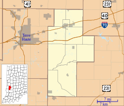
The Bogle family lent the community its name. [2]
Bogle Corner is located at 39°10′39″N87°11′05″W / 39.17750°N 87.18472°W .
Clay County is a county located in the U.S. state of Indiana. As of 2020, the population was 26,466. The county seat is Brazil.
Sugar Creek Township is one of thirteen townships in Parke County, Indiana, United States. As of the 2010 census, its population was 322 and it contained 154 housing units. The township includes the north half of Turkey Run State Park.
Wabash Township is one of thirteen townships in Parke County, Indiana, United States. As of the 2010 census, its population was 818 and it contained 353 housing units.
Brown Township is one of eleven townships in Montgomery County, Indiana, United States. As of the 2010 census, its population was 1,719 and it contained 739 housing units.
Ripley Township is one of eleven townships in Montgomery County, Indiana, United States. As of the 2010 census, its population was 977 and it contained 456 housing units.
Morris is an unincorporated community in Adams Township, Ripley County, in the U.S. state of Indiana.
Grange Corner is an unincorporated community in southeastern Lost Creek Township, Vigo County, in the U.S. state of Indiana.
Benefiel Corner is an unincorporated community in Hamilton Township, Sullivan County, in the U.S. state of Indiana.
Buchanan Corner is an unincorporated community in Lewis Township, Clay County, Indiana, United States. It is part of the Terre Haute Metropolitan Statistical Area.
Lap Corner is an unincorporated community in northern Sugar Ridge Township, Clay County, Indiana, just north of Center Point. It is part of the Terre Haute Metropolitan Statistical Area.
Roadman Corner is an unincorporated community in Jackson Township, Clay County, Indiana, United States. It is part of the Terre Haute Metropolitan Statistical Area.
Catlin is an unincorporated community in the northwest corner of Raccoon Township, Parke County, in the U.S. state of Indiana.
Grange Corner is an unincorporated community in Sugar Creek Township, Parke County, in the U.S. state of Indiana.
Tangier is an unincorporated community in Liberty Township, Parke County, in the U.S. state of Indiana.
Harrisville is an unincorporated community in Wayne Township, Randolph County, in the U.S. state of Indiana.
Antioch is an unincorporated community in the southwestern part of Wright Township, Greene County, Indiana, United States. It lies near the intersection of County Road 575 North and County Road 500 North, which is a community nearly twenty miles west of the city of Bloomfield, the county seat of Greene County. Its elevation is 531 feet, and it is located at 39°05′55″N87°14′15″W.
Hubbell is an unincorporated community in the southwestern corner of Jefferson Township, Owen County, in the U.S. state of Indiana. It lies near the intersection of County Road 750 South and Indiana Highway 157, which is a community nearly twenty miles southwest of the city of Spencer, the county seat. Its elevation is 528 feet, and it is located at 39°10′59″N87°0′44″W. This community is also known as Hubbells Station.
Smithville is an unincorporated community in the northwest corner of Marion Township, Owen County, in the U.S. state of Indiana. It lies near the intersection of County Road 200 North and County Road 1400 West, which is a community about fifteen miles west of the city of Spencer, the county seat. Its elevation is 591 feet, and it is located at 39°19′15″N87°1′33″W.
Hickory Corner is an unincorporated community in the northwest corner of Marion Township, Owen County, in the U.S. state of Indiana. It lies near the intersection of County Road 1500 West and Orman Road, which is a community about twenty miles west of the city of Spencer, the county seat. Its elevation is 643 feet, and it is located at 39°18′18″N87°2′40″W.
This community was named for the local Bogle family.