A ferry is a watercraft that carries passengers, and sometimes vehicles and cargo, across a body of water. A small passenger ferry with many stops, such as in Venice, Italy, is sometimes called a water taxi or water bus.

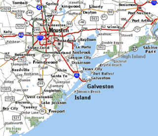
Galveston County is a county in the U.S. state of Texas, located along the Gulf Coast adjacent to Galveston Bay. As of the 2020 census, its population was 350,682. The county was founded in 1838. The county seat is the City of Galveston, founded the following year, and located on Galveston Island. The most-populous municipality in the county is League City, a suburb of Houston at the northern end of the county, which surpassed Galveston in population during the early 2000s.

Interstate 45 (I-45) is a major Interstate Highway located entirely within the U.S. state of Texas. While most primary Interstate routes which have numbers ending in "5" are cross-country north–south routes, I-45 is comparatively short, with the entire route located within Texas. Additionally, it has the shortest length of all the primary Interstates that have numbers ending in a "5". It connects the cities of Dallas and Houston, continuing southeast from Houston to Galveston over the Galveston Causeway to the Gulf of Mexico.

Bolivar Peninsula is a census-designated place (CDP) in Galveston County, Texas, United States. The population was 2,769 at the 2020 census. The communities of Port Bolivar, Crystal Beach, Caplen, Gilchrist, and High Island are located on Bolivar Peninsula.

Washington State Ferries (WSF) is a government agency that operates automobile and passenger ferry service in the U.S. state of Washington as part of the Washington State Department of Transportation. It runs ten routes serving 20 terminals located around Puget Sound and in the San Juan Islands, designated as part of the state highway system. The agency maintains a fleet of 21 vessels that are able to carry passengers and vehicles.

Galveston Bay is a bay in the western Gulf of Mexico along the upper coast of Texas. It is the seventh-largest estuary in the United States, and the largest of seven major estuaries along the Texas Gulf Coast. It is connected to the Gulf of Mexico and is surrounded by sub-tropical marshes and prairies on the mainland. The water in the bay is a complex mixture of sea water and fresh water, which supports a wide variety of marine life. With a maximum depth of about 10 feet (3 m) and an average depth of only 6 feet (2 m), it is unusually shallow for its size.

Galveston Island is a barrier island on the Texas Gulf Coast in the United States, about 50 miles (80.5 km) southeast of Houston. The entire island, with the exception of Jamaica Beach, is within the city limits of the City of Galveston in Galveston County.

Port Bolivar is an unincorporated community located on the northern shore of the western tip of the Bolivar Peninsula, separated from Galveston Island by the entrance to Galveston Bay. The Bolivar Peninsula itself is a census-designated place, in Galveston County, Texas, United States, and part of the Houston–Sugar Land–Baytown metropolitan area. The entire peninsula was severely damaged during Hurricane Ike on September 13, 2008; re-building efforts were still continuing as late as 2013.

High Island is an unincorporated community located in the Bolivar Peninsula census-designated place, Galveston County, Texas, United States. The community is located in the extreme eastern part of the county on Bolivar Peninsula, less than one mile from Chambers County and less than two miles from Jefferson County. As of 2000, 500 people resided in High Island. The 2010 census did not record a population for High Island.
The Trans-Texas Corridor (TTC) was a proposal for a transportation network in the U.S. State of Texas that was conceived to be composed of a new kind of transportation modality known as supercorridors. The TTC was initially proposed in 2001 and after considerable controversy was discontinued by 2010 in the planning and early construction stages.

The Houston Ship Channel, in Houston, Texas, is part of the Port of Houston, one of the busiest seaports in the world. The channel is the conduit for ocean-going vessels between Houston-area terminals and the Gulf of Mexico, and it serves an increasing volume of inland barge traffic.

State Highway 87 runs for 249.4 miles (401.4 km) between Galveston, Texas to U.S. Highway 59 and U.S. Highway 84 in Timpson, Texas.
Gilchrist, Texas is an unincorporated residential community and beachfront resort along State Highway 87, located seventeen miles east of Bolivar Point in the Bolivar Peninsula census-designated place, in Galveston County, Texas, United States.

State Highway 124 is a state highway in the U.S. state of Texas maintained by the Texas Department of Transportation (TxDOT). The highway begins along the Gulf Coast near the northeast end of the Bolivar Peninsula at SH 87 and extends to the northeast ending at US 69 and US 96. In between, the highway has major intersections with SH 65 and SH 73. The highway is located in Galveston, Chambers, and Jefferson counties and also serves the communities of Hamshire, Fannett, and Cheek. A portion of SH 124 is part of a longer coastal hurricane evacuation route.

State Highway 225 is an east–west freeway in the Houston area between the Interstate 610 Loop in Houston and State Highway 146/future State Highway 99 in La Porte. It is identified as the Pasadena Freeway over its entire length except for La Porte where it is called the La Porte Freeway. The freeway passes near several refineries, chemical plants, and tank farms as it passes through Pasadena and Deer Park.

The Texas Department of Transportation (TxDOT) is a governmental agency and its purpose is to "provide safe, effective, and efficient movement of people and goods" throughout the state. Though the public face of the agency is generally associated with maintenance of the state's immense highway system, the agency is also responsible for aviation in the state and overseeing public transportation systems.

The George and Cynthia Mitchell Memorial Causeway is a set of causeways in Galveston, Texas, United States. Two of the routes carry the southbound and northbound traffic of Interstate 45, while the original causeway is restricted to rail traffic. It is the main roadway access point to Galveston Island. The second access point is Bolivar Ferry.
The Texas City Dike is a levee located in Texas City, Texas, United States that projects nearly 5 miles (8.0 km) south-east into the mouth of Galveston Bay. It is flanked by the north-eastern tip of Galveston Island and the south-western tip of the Bolivar Peninsula. The dike, one of the area's most beloved and enduring landmarks, was originally designed to reduce the impact of sediment accumulation along the lower Bay.
Caplen is an unincorporated community that is part of the Bolivar Peninsula census-designated place, in Galveston County, Texas, United States.

Bolivar Roads is a natural navigable strait fringed by Bolivar Peninsula and Galveston Island emerging as a landform on the Texas Gulf Coast. The natural waterway inlet has a depth of 45 feet (14 m) with an island to peninsula shoreline width of 1.5 miles (2.4 km).


