
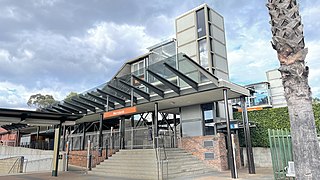
Liverpool railway station is a heritage-listed railway station located on the Main Southern line, serving the Sydney suburb of Liverpool in Australia. It is served by Sydney Trains T2 Inner West & Leppington, T3 Bankstown and T5 Cumberland services. It was added to the New South Wales State Heritage Register on 2 April 1999.

Wentworthville is a suburb in Sydney, in the state of New South Wales, Australia. Wentworthville is located 27 kilometres west of the Sydney central business district and is part of the Greater Western Sydney region. Wentworthville is split between the local government areas of the City of Parramatta and the Cumberland Council. Wentworthville is colloquially known as 'Wenty'.

Lidcombe railway station is a heritage-listed railway station located on the Main Suburban line, serving the Sydney suburb of Lidcombe. It is served by Sydney Trains T1 Western, T2 Inner West & Leppington, T3 Bankstown and T7 Olympic line services.

Cabramatta railway station is located on the Main Southern line, serving the Sydney suburb of Cabramatta. It is served by Sydney Trains T2 Inner West & Leppington, T3 Bankstown and T5 Cumberland line services.
Merrylands railway station is a heritage-listed railway station located on the Main South line, serving the Sydney suburb of Merrylands. It is served by Sydney Trains T2 Inner West & Leppington and T5 Cumberland line services.

Villawood railway station is a heritage-listed railway station located on the Main Southern line, serving the Sydney suburb of Villawood. It is served by Sydney Trains T3 Bankstown line services.

Parramatta railway station is a heritage-listed railway station located on the Main Western line, serving Parramatta in New South Wales, Australia. It is served by Sydney Trains T1 Western Line, T2 Inner West & Leppington and T5 Cumberland Line services and NSW TrainLink Blue Mountains Line, Central West XPT and Outback Xplorer services.
Mount Pritchard is a suburb of Sydney, in the state of New South Wales, Australia 34 kilometres south-west of the Sydney central business district, in the local government areas of the City of Fairfield and the City of Liverpool, and is part of the South-western Sydney region.

The State Transit Authority of New South Wales, also referred to as State Transit, was an agency of the Government of New South Wales operating bus services in Sydney. Superseding the Urban Transit Authority in 1989, it was also responsible for the provision of ferry services in Sydney until 2004 and bus and ferry services in Newcastle until 2017. It ceased trading after 2 April 2022 with its remaining operations to be contracted out by Transport for NSW to replacement operators.

Bonnyrigg is a suburb of Sydney, in the state of New South Wales, Australia 36 kilometres west of the Sydney central business district, in the local government area of the City of Fairfield. It is part of the Greater Western Sydney region.
Bringelly is a suburb of Sydney, in the state of New South Wales, Australia. It is located on the Northern Road between Penrith and Camden. It has a public school. Bringelly is also the name of a local hill.
Canley Heights is a suburb of Sydney, in the state of New South Wales, Australia 31 kilometres west of the Sydney central business district, in the local government area of the City of Fairfield and is part of the South-western Sydney region.

Cartwright is a suburb in south-western Sydney, in the state of New South Wales, Australia 38 kilometres south-west of the Sydney central business district, in the local government area of the City of Liverpool.

Enfield is a suburb in the Inner West of Sydney, in the state of New South Wales, Australia. It is 11 kilometres south-west of the Sydney central business district in the local government area of Municipality of Burwood.
Greenfield Park is a suburb of Sydney, in the state of New South Wales, Australia. Greenfield Park is located 36 kilometres west of the Sydney central business district in the local government area of the City of Fairfield. The suburb has one of the most highest proportion of Assyrian people in the Sydney area and Australia per se.

Westbus was an Australian bus and coach operator that operated bus services in Western Sydney from 1955 until October 2013. Founded by the Bosnjak family, it later became a subsidiary of National Express and later ComfortDelGro Cabcharge.
The Liverpool–Parramatta T-way is a continuous series of bus-only lanes and bus roadways between Parramatta and Liverpool in Western Sydney. Completed in February 2003, the 31 km (19.3 mi) T-way was the first bus rapid transit infrastructure to be built in Sydney.

Transit Systems NSW, previously known as Transit Systems Sydney, is a bus operator in Sydney, New South Wales, Australia. It is a subsidiary of Transit Systems.

The Inner West & Leppington Line is a commuter rail service currently operated by Sydney Trains, serving the inner west and south-western regions of Sydney, Australia. Consisting of 37 stops, the service commences from the City Circle, then heads west to Granville. The line branches at this point; services either head northwest to Parramatta or south to Leppington. A third terminus at Homebush is used when the part-time Parramatta branch isn't operating. The line commenced operations on 26 November 2017, replacing the T2 Airport, Inner West & South Line.
Elizabeth Hills is a suburb of western Sydney, in the state of New South Wales, Australia. It is located 39 kilometres south-west of the Sydney central business district, in the local government area of Liverpool. Elizabeth Hills was gazetted as a suburb on 18 December 2009. Like the neighbouring suburb of Len Waters Estate, Elizabeth Hills had previously been part of the suburb of Cecil Hills.
