
Shannon is a small unincorporated community located in Jefferson County, Alabama, United States, between Birmingham and northwest Hoover named after John James Shannon, a mine operator. A post office first opened under the name Shannon in 1915.
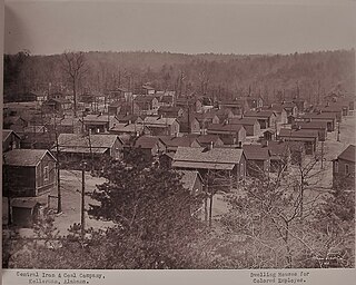
Kellerman is an unincorporated community in Tuscaloosa County, Alabama, United States, six miles (9.7 km) north of Brookwood. The community formed around a coal mining operation owned by the Central Iron & Coal Co. of New York. Kellerman was a company town, and the houses were owned by the company. When mining operations ceased in 1962, almost all of the nearly 5,000 residents eventually moved away leaving less than 10 houses remaining. The Kellerman post office with ZIP code 35468, which opened on August 6, 1902, is now located at the Alabama Mining Museum in Dora, Alabama Kellerman was most likely named for a civil engineer with the Kellerman Mine Company.
Kimbrell is an unincorporated community in Jefferson and Tuscaloosa counties, Alabama, United States. Kimbrell was named in honor of Miles Kimbrell, a storekeeper and sewing machine agent. A post office operated under the name Kimbrel from 1895 to 1905.

Calcis is an unincorporated community in Shelby County, Alabama, United States, located along Alabama State Route 25, 3 miles (4.8 km) north-northwest of Vincent.
Moores Bridge, also spelled Moors Bridge, is an unincorporated community in Tuscaloosa County, Alabama, United States. Moores Bridge is located along Alabama State Route 171, 24 miles (39 km) north-northwest of Tuscaloosa.
Lubbub is an unincorporated community in Pickens County, Alabama, United States. Lubbub is located along Alabama State Route 159, 8.8 miles (14.2 km) north of Gordo.

Manchester is an unincorporated community in Walker County, Alabama, United States. Manchester is located along Alabama State Route 195, 6.1 miles (9.8 km) north-northeast of Jasper.
Coal Valley, also known as Cormick, is an unincorporated community in Walker County, Alabama, United States.
Corona is an unincorporated community in Walker County, Alabama, United States. Corona is located on Alabama State Route 18, 4.6 miles (7.4 km) west of Oakman.
Caffee Junction, also known as Coffey Junction, Greeley, Martaban, and Rickey, is an unincorporated community in Tuscaloosa County, Alabama, United States. Caffee Junction is located along U.S. Route 11, 4.1 miles (6.6 km) north-northeast of Woodstock.

Marvel is an unincorporated community in Bibb County, Alabama, United States.
Fadette is an unincorporated community in Geneva County, Alabama, United States. Fadette is located on Alabama State Route 103, 5.4 miles (8.7 km) southeast of Slocomb.
Potash is an unincorporated community in Randolph County, Alabama, United States.
Howard, also known as Howard Mines or Stovalls Gap, is an unincorporated community in Fayette County, Alabama, United States.
Keener, also known as Greenwood, is an unincorporated community in Etowah County, Alabama, United States.
Coatopa is an unincorporated community in Sumter County, Alabama, United States.
Piper is an unincorporated community in Bibb County, Alabama, United States.
Fatama, also known as Fatima, is an unincorporated community in Wilcox County, Alabama, United States.

Chinnabee, also spelled Chinneby or Chinnibee, is an unincorporated community in Talladega County, Alabama, United States.
Fernbank is an unincorporated community in Lamar County, Alabama, United States, on the north bank of Luxapallila Creek. Fernbank is located approximately five miles northwest of Millport.


