
Cayce is a city in the U.S. state of South Carolina, along the Congaree River. The population was 12,528 at the 2010 census and rose to 13,789 in the 2020 United States Census, and it is the third-most populated municipality in Lexington County. The city is primarily in Lexington County, with additional, predominantly rural land to the east in Richland County. Cayce is part of the Columbia Metropolitan Statistical Area and is within South Carolina's Midlands region.

This is a list of the National Register of Historic Places listings in Charleston County, South Carolina.

This is a list of the National Register of Historic Places listings in Richland County, Wisconsin. It is intended to provide a comprehensive listing of entries in the National Register of Historic Places that are located in Richland County, Wisconsin. The locations of National Register properties for which the latitude and longitude coordinates are included below may be seen in a map.

Gervais Street Bridge is a historic bridge in South Carolina in the United States and it is listed on the National Register of Historic Places. It is an arch bridge constructed from reinforced concrete. Construction began in 1926 and the bridge was completed in 1928. It was added to the National Register of Historic Places in 1980.
Grovewood, also known as Weston House, is a historic home near Congaree, Richland County, South Carolina. The original one-story dwelling was built about 1765, and moved to this site and enlarged to two-stories about 1835. It is a frame dwelling, with a stuccoed brick foundation, weatherboard siding, and a low hipped roof. Also on the property is a contributing frame kitchen.
Magnolia, now known as Wavering Place also previously known as the Francis Tucker Hopkins House, is a historic plantation house located near Gadsden, Richland County, South Carolina. It was built about 1855, and is a two-story, Greek Revival style frame building with a full stuccoed brick basement and weatherboard siding. The front facade features a portico with columns rest on tall stuccoed pedestals. Also on the property are a brick kitchen/office, a frame smokehouse and two one-story frame slave houses.
Siloam School is a historic school building located at Eastover, Richland County, South Carolina. It was built about 1936, and is a one-story, two-room building built with funds from the Works Progress Administration (WPA). It stands on a brick pier foundation and is clad in shiplap weatherboard siding. It operated as a school for African-American children until 1956.

Olympia Armory is a historic National Guard armory located at Olympia, near Columbia, Richland County, South Carolina.
Big Lake Cattle Mound is a historic earthen cattle mound located in Congaree National Park near Hopkins, Richland County, South Carolina. It was built by settlers in the Congaree Swamp to provide a place of refuge for hogs, cattle, and other grazing animals during the flood season. The Big Lake Cattle Mount measures 75 feet long by 35 feet wide, with a 2 foot tall flat top.
Cattle Mound No. 6, also known as Georgia Pacific Cattle Mound, is a historic earthen cattle mound located in Congaree National Park near Hopkins, Richland County, South Carolina. It was built by settlers in the Congaree Swamp to provide a place of refuge for hogs, cattle, and other grazing animals during the flood season. Cattle Mound No. 6 is an oval mound measuring approximately 400 feet in diameter, with an 8 to 10 foot tall flat top.

Cook's Lake Cattle Mound is a historic earthen cattle mound located in Congaree National Park near Hopkins, Richland County, South Carolina, United States. It was built by settlers in the Congaree Swamp to provide a place of refuge for hogs, cattle, and other grazing animals during the flood season. Cook's Lake Cattle Mound is an oval mound measuring approximately 165 feet in diameter, with a 3 foot tall flat top.

Cooner's Cattle Mound is a historic earthen cattle mound located in Congaree National Park near Hopkins, Richland County, South Carolina, United States. It was built by settlers in the Congaree Swamp to provide a place of refuge for hogs, cattle, and other grazing animals during the flood season. Cooner's Cattle Mound is an oval mound measuring approximately 300 feet in diameter, with a 5 to 10 foot tall flat top.
Dead River Cattle Mound is a historic earthen cattle mound located in Congaree National Park near Hopkins, Richland County, South Carolina. It was built by settlers in the Congaree Swamp to provide a place of refuge for hogs, cattle, and other grazing animals during the flood season. Dead River Cattle Mound is an oval mound measuring approximately 250 feet in diameter, with a 3 to 5 foot tall flat top.
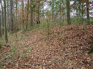
Bridge Abutments are four pair of historic earthen bridge abutments located in Congaree National Park near Hopkins, Richland County, South Carolina. They were built by settlers in the 1780s in the Congaree Swamp to provide a means of transporting produce and livestock to markets in cities, such as Charleston. They vary in size from 5-to-10-feet high and 10-to-15-feet wide.
Dead River Dike is a historic earthen dike located in Congaree National Park near Hopkins, Richland County, South Carolina. It was built by settlers in the Congaree Swamp to control the periodic flooding of the Congaree River and utilize the fertile swampland. The Dead River Dike is an L-shaped earthen structure measuring 4-to-5-foot high, with one leg approximately 2000 feet long and the second approximately 800 feet long.
Northwest Boundary Dike is a historic earthen dike located near Hopkins, Richland County, South Carolina. It was built about 1840 by settlers in the Congaree Swamp to control the periodic flooding of the Congaree River and utilize the fertile swampland. The Northwest Boundary Dike measures approximately 10-to-30-foot-wide-by-5-foot-high, and runs for approximately 2000 feet.
Southwest Boundary Dike is a historic earthen dike located in Congaree National Park near Hopkins, Richland County, South Carolina. It was built by settlers in the Congaree Swamp to control the periodic flooding of the Congaree River and utilize the fertile swampland. The Southwest Boundary Dike measures approximately 3-to-4-foot high, and runs for approximately 650 feet, interrupted by a gut of water, and then continues for approximately 1,300 to 1,400 feet.
Hopkins Family Cemetery is a historic family cemetery located near Hopkins, Richland County, South Carolina. It was established about 1775, on the Back Swamp Plantation. A wall and stile were built about 1835–1837. It contains 69 marked graves of the Hopkins and related families.
Laurelwood is a historic plantation house located in rural Richland County, South Carolina, near the city of Eastover. It was built about 1830, and is a two-story frame dwelling with a central-hall, double-pile plan. The front façade features a two-tier, three bay, pedimented portico in the Greek Revival style. It has a one-story, frame addition built in the early-20th century. Also on the property are the contributing frame smokehouse and a frame barn. Also notable is the survival of a slave quarters.

Richland Cotton Mill, also known as Pacific Mills, Lowenstein Mill, and Whaley's Mill, is a historic cotton mill building located at Columbia, South Carolina. It was built in 1894, and is a four-story, rectangular brick mill building. It features a seven-story stair tower, with a circular vent flanked by two arched vents. Attached to the building are an engine room, a boiler room with chimney, and a machine shop.


