Related Research Articles

Cayce is a city in the U.S. state of South Carolina, along the Congaree River. The population was 12,528 at the 2010 census. The estimated population was 14,009 in 2019, and it is the third-most populated municipality in Lexington County. The city is primarily in Lexington County, with additional, predominantly rural land to the east in Richland County. Cayce is part of the Columbia Metropolitan Statistical Area and is within South Carolina's Midlands region.
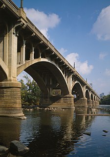
Gervais Street Bridge is a historic bridge in South Carolina in the United States and it is listed on the National Register of Historic Places. It is an arch bridge constructed from reinforced concrete. Construction began in 1926 and the bridge was completed in 1928. It was added to the National Register of Historic Places in 1980.

Grovewood, also known as Weston House, is a historic home near Congaree, Richland County, South Carolina. The original one-story dwelling was built about 1765, and moved to this site and enlarged to two-stories about 1835. It is a frame dwelling, with a stuccoed brick foundation, weatherboard siding, and a low hipped roof. Also on the property is a contributing frame kitchen.
Siloam School is a historic school building located at Eastover, Richland County, South Carolina. It was built about 1936, and is a one-story, two-room building built with funds from the Works Progress Administration (WPA). It stands on a brick pier foundation and is clad in shiplap weatherboard siding. It operated as a school for African-American children until 1956.
Big Lake Cattle Mound is a historic earthen mound located in Congaree National Park near Hopkins, Richland County, South Carolina. It was built by settlers in the Congaree Swamp to provide a place of refuge for hogs, cattle, and other grazing animals during the flood season. The Big Lake Cattle Mount measures 75 feet long by 35 feet wide, with a 2 foot tall flat top.
Brady's Cattle Mound is a historic earthen mound located in Congaree National Park near Hopkins, Richland County, South Carolina. It was built about 1900 by settlers in the Congaree Swamp to provide a place of refuge for hogs, cattle, and other grazing animals during the flood season. Brady's Cattle Mount is an oval mound measuring approximately 300 feet in diameter, with a 6 to 7 foot tall flat top. It remains in use.
Cattle Mound No. 6, also known as Georgia Pacific Cattle Mound, is a historic earthen mound located in Congaree National Park near Hopkins, Richland County, South Carolina. It was built by settlers in the Congaree Swamp to provide a place of refuge for hogs, cattle, and other grazing animals during the flood season. Cattle Mound No. 6 is an oval mound measuring approximately 400 feet in diameter, with an 8 to 10 foot tall flat top.

Cook's Lake Cattle Mound is a historic earthen mound located in Congaree National Park near Hopkins, Richland County, South Carolina. It was built by settlers in the Congaree Swamp to provide a place of refuge for hogs, cattle, and other grazing animals during the flood season. Cook's Lake Cattle Mound is an oval mound measuring approximately 165 feet in diameter, with a 3 foot tall flat top.

Cooner's Cattle Mound is a historic earthen mound located in Congaree National Park near Hopkins, Richland County, South Carolina. It was built by settlers in the Congaree Swamp to provide a place of refuge for hogs, cattle, and other grazing animals during the flood season. Cooner's Cattle Mound is an oval mound measuring approximately 300 feet in diameter, with a 5 to 10 foot tall flat top.
Dead River Cattle Mound is a historic earthen mound located in Congaree National Park near Hopkins, Richland County, South Carolina. It was built by settlers in the Congaree Swamp to provide a place of refuge for hogs, cattle, and other grazing animals during the flood season. Dead River Cattle Mound is an oval mound measuring approximately 250 feet in diameter, with a 3 to 5 foot tall flat top.
Bridge Abutments are four pair of historic earthen bridge abutments located in Congaree National Park near Hopkins, Richland County, South Carolina. They were built by settlers in the 1780s in the Congaree Swamp to provide a means of transporting produce and livestock to markets in cities, such as Charleston. They vary in size from 5-to-10-feet high and 10-to-15-feet wide.
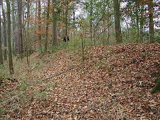
Northwest Boundary Dike is a historic earthen dike located near Hopkins, Richland County, South Carolina. It was built about 1840 by settlers in the Congaree Swamp to control the periodic flooding of the Congaree River and utilize the fertile swampland. The Northwest Boundary Dike measures approximately 10-to-30-foot-wide-by-5-foot-high, and runs for approximately 2000 feet.
Southwest Boundary Dike is a historic earthen dike located in Congaree National Park near Hopkins, Richland County, South Carolina. It was built by settlers in the Congaree Swamp to control the periodic flooding of the Congaree River and utilize the fertile swampland. The Southwest Boundary Dike measures approximately 3-to-4-foot high, and runs for approximately 650 feet, interrupted by a gut of water, and then continues for approximately 1,300 to 1,400 feet.
Unnamed Battery No. 1 is a historic artillery battery located at Clark's Point, James Island, Charleston County, South Carolina. It was built in 1862, and was the southern end of the eastern James Island line. At the end of the war this battery mounted two field guns. The earthen redoubt measures approximately 240 feet long and 200 feet wide. It has a 12 foot high parapet wall and a powder magazine about 17 feet in height.
Fort Palmetto is a historic artillery battery located at Christ Church Parish, Hamlin Sound, Charleston County, South Carolina. It was built in late 1861, and was at the easternmost end of the Christ Church Parish line of defense. At the end of the war this battery mounted one nine-inch gun and two rifled thirty-two pounders. The earthen redoubt measures approximately 160 feet long and 80 feet wide. It has a 15 foot high parapet wall and a powder magazine about 25 feet in height.
Battery Cheves is a historic artillery battery located at James Island, Charleston, South Carolina. It was built in 1863, and designed to protect the area between Fort Johnson and Battery Haskell. At the end of the war this battery mounted two pieces of heavy artillery. The earthen redoubt measures approximately 280 feet long and 240 feet deep. It has a 12-foot, 6 inch, high parapet wall and a powder magazine about 15 feet in height.
Battery Tynes is a historic artillery battery located at James Island, Charleston, South Carolina. It was built in 1863, and designed to protect the upper Stono River and the bridge from James Island to Johns Island, South Carolina. The earthen redoubt measures approximately 320 feet long and 180 feet deep. It has a 10–20 foot high parapet wall and a 15 feet high powder magazine.
Fort Pringle is a historic artillery battery located at James Island, Charleston, South Carolina. It was built in 1863, as part of the James Island Siege Line and protect the Stono River, Johns Island and lower James Island. At the close of the war it was armed with nine heavy cannons. The earthen redoubt's river face measures approximately 360 feet, the right or upstream face 160 feet, the left or downstream face 400 feet, and the rear face approximately 520 feet in length. It has a 7.5 to 12.5 foot high parapet wall and 12.5 feet tall powder magazine.
Fort Trenholm, also known as Battery Trenholm, is a historic artillery battery located at Johns Island, Charleston, South Carolina. It was built in 1864, to reinforce Fort Pringle and protect the Stono River and Johns Island. It has emplacements for 17 guns. The three-sided earthen redoubt measures approximately 870 feet on its eastern face, 780 feet long on its southern face, and 885 feet long on its western face. It has a 15-foot-high parapet wall.
This is a list of the National Register of Historic Places listings in Congaree National Park.
References
- 1 2 "National Register Information System". National Register of Historic Places . National Park Service. July 9, 2010.
- ↑ Jill Hanson (n.d.). "Dead River Dike" (pdf). South Carolina Inventory Form for Historic Districts and Individual Properties in a Multiple Property Submission. Retrieved 2014-07-01.
- ↑ "Dead River Dike, Richland County (Address Restricted)". National Register Properties in South Carolina. South Carolina Department of Archives and History. Retrieved 2014-07-01.
| Wikimedia Commons has media related to Dead River Dike . |
| Topics |  | |
|---|---|---|
| Lists by county |
| |
| Lists by city | ||
| Other lists | ||
| | This article about a property in Richland County, South Carolina on the National Register of Historic Places is a stub. You can help Wikipedia by expanding it. |