
Backstone Bank and Baal Hill Woods is a Site of Special Scientific Interest in the County Durham district of Durham, England. It occupies the steep eastern slopes of the valley of Waskerley Beck, alongside and downstream of Tunstall Reservoir, some 3 km north of Wolsingham and is one of the largest expanses of semi-natural woodland in west Durham.

Dizzard is an area, in the civil parish of St Gennys, Cornwall, containing five farms. On the coast is Dizzard Point, and the unique, dwarf oak, Dizzard Wood, which is of international importance for its lichen communities.
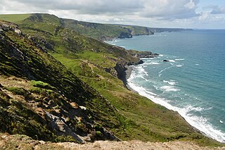
Boscastle to Widemouth is a coastal Site of Special Scientific Interest (SSSI) in Cornwall, England, noted for its biological and geological characteristics. The Dizzard dwarf oak woodland is unique and of international importance for its lichen communities, with 131 species recorded.
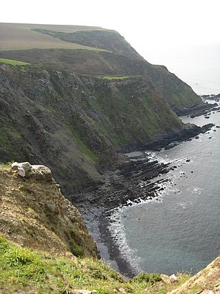
Steeple Point to Marsland Mouth is a coastal Site of Special Scientific Interest (SSSI) in Cornwall, England, UK, noted for its biological characteristics.

Graig Wood is a Site of Special Scientific Interest (SSSI), noted for its biological characteristics, in Monmouthshire, south east Wales. It forms part of the wider Hael Woods complex.

Lower Hael Wood is a semi-ancient woodland and Site of Special Scientific Interest (SSSI), noted for its biological characteristics, in Monmouthshire, south east Wales. It is part of the wider Hael Woods complex. The wood is on the side of the River Wye which is the border between Wales and England.

Upper Wye Gorge is a Site of Special Scientific Interest (SSSI), noted for its biological and geological characteristics, around Symonds Yat in the Wye Valley on the Wales–England border. The site is listed in the "Forest of Dean Local Plan Review" as a Key Wildlife Site (KWS).

Bigsweir Woods is a 48.16-hectare (119.0-acre) biological Site of Special Scientific Interest in Gloucestershire, notified in 1984. The site is listed in the 'Forest of Dean Local Plan Review' as a Key Wildlife Site (KWS).
Shorn Cliff And Caswell Woods is a 69.2-hectare (171-acre) biological Site of Special Scientific Interest in Gloucestershire, notified in 1986. The site is listed in the 'Forest of Dean Local Plan Review' as a Key Wildlife Site (KWS).

The Hudnalls is a 94.4-hectare (233-acre) biological Site of Special Scientific Interest in Gloucestershire, notified in 1972. The site is listed in the 'Forest of Dean Local Plan Review' as a Key Wildlife Site (KWS).

The Allen Confluence Gravels is the name given to a Site of Special Scientific Interest (SSSI) in Northumberland, England. The site, listed since 1968, has an 'outstanding assemblage of river margin invertebrates.'
Allolee to Walltown is the name given to a Site of Special Scientific Interest (SSSI) in Northumberland, England. The site, which follows the path of a section of Hadrian's Wall, is notable for an unusually wide range of grassland types growing on thin soil above the Whin Sill, a rock formation peculiar to the Northern Pennines.
Bamburgh Coast and Hills is the name given to a Site of Special Scientific Interest (SSSI) on the coast of north Northumberland, England. The site is one of the longest-standing SSSIs in England, having been listed since 1954, and displays the interaction of a fluid magma rock, now known as the Whin Sill, interacting with older sedimentary rock. Coastal erosion at the site enables sections of the geological strata to be seen. In turn, the soil associated with the Whin Sill gives rise to a distinct pattern of vegetation which on its own merits is at this site found notable.
Barrow Burn Meadows is a Site of Special Scientific Interest (SSSI) in north Northumberland, England. The site is a species-rich hay meadow of a sort now rare in Northumberland.
Barrow Meadow is a Site of Special Scientific Interest (SSSI) in north Northumberland, England. The site is a species-rich hay meadow of a sort now rare in Northumberland.
Billsmoor Park and Grasslees Wood is the name given to a Site of Special Scientific Interest (SSSI) in Northumberland, North East England, designated in 1954. Billsmoor Park is an extensive alder woodland of a sort increasingly uncommon in the county; the much smaller Grasslees Wood is an oak woodland.
Brada Hill is a small hill escarpment near the coast of north Northumberland in North East England, designated as a Site of Special Scientific Interest (SSSI). The 2.4 hectares site is an outcropping of a local stone group, the Whin Sill, on which grows a range of flora representative of the thin, drought-prone soil conditions and influenced by the underlying geology.
Burnfoot River Shingle and Wydon Nabb is the name given to a Site of Special Scientific Interest (SSSI) in Northumberland, North East England. Burnfoot River Shingle is a calaminarian grassland on the River South Tyne where the local flora is influenced by high levels of naturally occurring heavy metals. Wydon Nabb is an escarpment displaying the Haltwhistle Dyke, a magmatic intrusion of igneous dolerite set amidst sedimentary sandstone and shale.

Hack Fall Wood, otherwise known as Hackfall, is a Site of Special Scientific Interest, or SSSI, of 44.8687 hectares, lying north-east of the village of Grewelthorpe, North Yorkshire, England. During the 18th century it was landscaped in the picturesque style by landowner William Aislabie, who created views by engineering streams and pools, planting trees and building follies. J. M. W. Turner and William Sawrey Gilpin painted it, and pictures of it featured on Catherine the Great's 1773 Wedgwood dinner service. Some 19th century writers called it "one of the most beautiful woods in the country."
Naddle Forest is a Site of Special Scientific Interest (SSSI) within the Lake District National Park in Cumbria, England. It is located on either side of the northern section of Haweswater reservoir, near the villages; Burnbanks and Bampton.
