
Minnesota State Highway 23 (MN 23) is a state highway that stretches from southwestern to northeastern Minnesota. At 343.723 miles (553.169 km) in length, it is the second longest state route in Minnesota, after MN 1.

Jay Cooke State Park is a state park of Minnesota, United States, protecting the lower reaches of the Saint Louis River. The park is located about 10 miles (16 km) southwest of Duluth and is one of the ten most visited state parks in Minnesota. The western half of the park contains part of a rocky, 13-mile (21 km) gorge. This was a major barrier to Native Americans and early Europeans traveling by canoe, which they bypassed with the challenging Grand Portage of the St. Louis River. The river was a vital link connecting the Mississippi waterways to the west with the Great Lakes to the east.

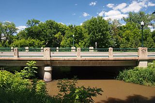
The Zumbro Parkway Bridge is a historic arch bridge with two 25-foot (7.6 m) spans over a tributary of the Zumbro River just outside the city of Zumbro Falls in Hyde Park Township, Minnesota, United States. It was constructed in 1937 by the Works Progress Administration using a modular corrugated iron product known as Multi Plate, and given a masonry veneer with Gothic Revival details. The bridge was listed on the National Register of Historic Places in 1989 for having state-level significance in the theme of engineering. It was nominated for being one of Minnesota's finest examples of a stone-faced Multi Plate arch highway bridge, a style used in many of the state's New Deal bridge projects.

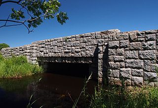
Bridge 5827 is a historic arch bridge in Zumbro Falls, Minnesota, United States, built in 1938 by the Works Progress Administration using a modular corrugated iron product called Multi Plate. It was listed on the National Register of Historic Places as the Bridge No. 5827–Zumbro Falls in 1998 for having state-level significance in the theme of engineering. It was nominated as an example of Minnesota's stone-faced Multi Plate bridges with particularly fine masonry.
Fond du Lac is a neighborhood in Duluth, Minnesota, United States.

The Stewart Creek Bridge or Bridge L6007 is a stone arch bridge in the Smithville neighborhood of Duluth, Minnesota, United States. It was built around 1925 as part of the scenic Skyline Parkway overlooking the city. The Stewart Creek Bridge was listed on the National Register of Historic Places in 1989 under the name Bridge No. L-6007 for its state-level significance in the theme of engineering. It was nominated for being the most picturesque stone arch road bridge in design and setting in Minnesota.

The Gateway Trail Iron Bridge is a historic camelback truss bridge on the Gateway State Trail in Stillwater Township, Minnesota, United States. The bridge has stood in three locations in Minnesota. Its main span was built of wrought iron in 1873—before steel became the preferred material for metal bridges—and erected in Sauk Centre in Central Minnesota. Designated Bridge No. 5721, it was refurbished and moved in 1937 to rural Koochiching County in northern Minnesota, where it became known as the Silverdale Bridge. It was relocated to its present site in east-central Minnesota in 2011 and renamed Bridge No. 82524. It was listed on the National Register of Historic Places in 1998 for its state-level significance in engineering. It was nominated as a rare example of a wrought iron truss bridge with ornamental detailing.

The US 41–Fanny Hooe Creek Bridge is a highway bridge located on US Highway 41 (US 41) over the Fanny Hooe Creek about one mile east of Copper Harbor, adjacent to Fort Wilkins State Park, in Grant Township, Michigan. It was listed on the National Register of Historic Places in 1999.

The Lincoln Highway Bridge is located in Tama, Iowa, United States, along the historic Lincoln Highway. The Steel stringer bridge was built in 1914, and it was listed on the National Register of Historic Places in 1978. It spans Mud Creek for 22 feet (6.7 m) with a width of 24 feet (7.3 m). The bridge is noteworthy for its distinctive railings. They are 3.33 feet (1.01 m) high, and feature the words "Lincoln Highway" in concrete. Local boosters of the Lincoln Highway paid for the railings as a way of promoting the roadway. The bridge was designed by the Iowa Highway Commission and built by Paul N. Kingsley, a contractor from Strawberry Point, Iowa.

The Colorado Department of Highways is the antecedent of today's Colorado Department of Transportation.
Bridge No. 5083-Marshall carries Minnesota State Highway 19 over the Redwood River in Marshall, Minnesota, United States. It was built 1931 and is one of two bridges on the historic register in the city. It was listed on the National Register of Historic Places in 1998.

Trunk Line Bridge No. 237 is a concrete arch bridge in Ransom Township, Michigan, that carries Burt Road over Silver Creek. Built in 1918, it is listed on the National Register of Historic Places.
Bridge Number 3355 in Kathio Township, in Mille Lacs County, Minnesota, is a concrete slab bridge that carries U.S. Route 169 (US 169) over Whitefish Creek near Mille Lacs Lake. It is listed on the National Register of Historic Places for its architectural significance, especially the ornamental stonework as designed by the National Park Service and built by the Civilian Conservation Corps.
The Lincoln Highway in Greene County, Iowa is a multiple property submission to the National Register of Historic Places, which was approved on March 29, 1993. It includes five individual listings and five historic districts located in Greene County, Iowa, United States. They encompass abandoned sections of dirt roads, paved sections that are now part of other highways, and various sites, objects, structures and pieces of infrastructure that were a part of the Lincoln Highway. The years of historical significance are 1912 to 1928.

Bridge No. 3589 in Silver Creek Township, Minnesota is a reinforced concrete arch bridge carrying Minnesota State Highway 61 over the Stewart River just north of Two Harbors, Minnesota. The bridge was built in 1924, originally with a 70 feet (21 m) span and a width of 19 feet (5.8 m). It was widened to 39 feet (12 m) in 1939 because of increasing traffic loads. The bridge was listed on the National Register of Historic Places in 1998.

The Holmes Street Bridge, also known the Holmes Street Pedestrian Bridge, Old Shakopee Bridge, or Bridge 4175, is a historic truss bridge over the Minnesota River in Shakopee, Minnesota, United States. It is one of the state's only examples of a deck truss bridge. It was constructed in 1927 with parts manufactured by the Minneapolis Steel & Machinery Company. The bridge formerly carried US 169 and MN 101, and served as the principal river crossing for Shakopee. The Holmes Street Bridge was closed to vehicular traffic in 2005. It was rehabilitated in 2011 to carry a trail for pedestrians, cross-country skiers, and snowmobiles.

The Whitehouse–Mechanicsville Historic District is a historic district located along old New Jersey Route 28, Mill, Lamington and School Roads in Whitehouse and Mechanicsville, unincorporated communities in Readington Township, Hunterdon County, New Jersey. It was added to the National Register of Historic Places on March 17, 2015 for its significance in architecture and community development. The district includes 140 contributing buildings.

The St. Alban's Bay Culvert is a historic bridge in Garrison Township, Minnesota, United States. It carries the four-lane U.S. Route 169 (US 169) over the head of a stream flowing out of Mille Lacs Lake. It was built from 1938 to 1939 as part of a major New Deal project to create a scenic parkway along the lakeshore. The bridge was listed on the National Register of Historic Places in 2015 as the St. Alban's Bay Culvert at Mille Lacs Lake for having state-level significance in the themes of architecture and politics/government. It was nominated for being a well-preserved example of the Minnesota Highway Department's earliest scenic improvements, its rare status as a highway bridge built by the department's Roadside Development Division—a unit usually focused on overlooks and waysides—and for its fine National Park Service rustic design.
The Kenney Lake Overlook is a historic roadside park in Garrison Township, Minnesota, United States. Adjacent to the southbound lane of Minnesota State Highway 18 (MN 18), the two-acre (0.8 ha) site provides a parking area and an overlook of a small lake. The wayside was built in 1939 as part of a major New Deal project to create a scenic parkway along the shore of nearby Mille Lacs Lake. The Mille Lacs Highway Development Plan was the largest highway improvement project in the state constructed by the Civilian Conservation Corps (CCC). The Kenney Lake Overlook was listed on the National Register of Historic Places in 2015 for having state-level significance in the themes of landscape architecture and politics/government. It was nominated for being a key component of a major highway improvement project, for representing the work of the Veterans Division of the CCC and the earliest scenic improvements of the Minnesota Highway Department (MHD), and for its fine National Park Service rustic design.

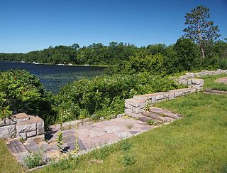
The Garrison Concourse is a roadside park on Mille Lacs Lake in Garrison, Minnesota, United States. The site consists of a wide parking area and scenic overlook projecting out into the lake, plus landscaped parkland along the shore in both directions. It was built from 1936 to 1939 as the centerpiece of the Mille Lacs Highway Development Plan, a major New Deal project to create a scenic parkway along the lakeshore. The park was listed on the National Register of Historic Places in 2013 for having state-level significance in the themes of landscape architecture and politics/government. It was nominated for being the premiere structure of the most extensive roadside development project undertaken by the Minnesota Highway Department and the Civilian Conservation Corps, and for its blend of formalism and National Park Service rustic design.


