Bridger Jack Butte

Last updated
Bridger Jack Butte
Bridger Jacks.jpg
Bridger Jack Butte, northeast aspect
Highest point
Elevation 5,890 ft (1,800 m) [1]
Prominence 280 ft (85 m) [2]
Parent peak Cotton Benchmark (6,747 ft) [2]
Isolation 1.62 mi (2.61 km) [2]
Coordinates 38°05′24″N109°35′58″W / 38.0901°N 109.5995°W / 38.0901; -109.5995 [2]
Geography
USA Utah relief location map.svg
Red triangle with thick white border.svg
Bridger Jack Butte
Location in Utah
Usa edcp relief location map.png
Red triangle with thick white border.svg
Bridger Jack Butte
Bridger Jack Butte (the United States)
Location Bears Ears National Monument
San Juan County, Utah, US
Parent range Colorado Plateau
Topo map USGS Harts Point South
Geology
Age of rock Late Triassic
Type of rock Wingate Sandstone
Climbing
First ascent 1983
Easiest route Wild Flower class 5.10+ climbing [2]

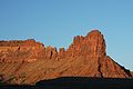
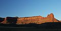
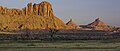
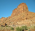
Bridger Jack Butte is a sandstone butte located in Bears Ears National Monument, in San Juan County, Utah, United States. Set at the northern tip of Bridger Jack Mesa and above the confluence of Indian and Lavender Creeks, the summit rises to an elevation of 5,890 feet (1,800 meters), and towers over 700 feet (210 meters) above the surrounding terrain and floor of Lavender Canyon to its west. [3] This landmark is situated four miles southeast of the Sixshooter Peaks, and is visible from State Route 211 between Newspaper Rock and the Needles District of Canyonlands National Park. "Bridger Jack" was a Paiute medicine man. [4]

Contents

Geology

Bridger Jack Butte is composed of hard, fine-grained Wingate Sandstone, the petrified remains of wind-borne sand dunes deposited approximately 200 million years ago in the Late Triassic. This Wingate Sandstone forms steep cliffs as it overlays softer layers of the Chinle Formation. [5] The next layer below this is the Moenkopi Formation. [6] Precipitation runoff drains into nearby Indian Creek, which is part of the Colorado River drainage basin.

Climbing

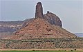
Bridger Jack Butte is set in the popular Indian Creek climbing area. The first ascent of Bridger Jack Butte was made June 12, 1983, by Ed Webster, Leonard Coyne, and Ellen Figi, via the Wild Flower route. [7] The "Bridger Jacks" are towers on the connecting ridge between the mesa and the butte. They have names such as "King of Pain", "Hummingbird Spire", "Sunflower Tower", "Easter Island", and "Thumbelina". [2]

Climbing routes on Bridger Jack Butte:

Climate

Spring and fall are the most favorable seasons to visit Bridger Jack Butte. According to the Köppen climate classification system, it is located in a cold semi-arid climate zone, which is defined by the coldest month having an average mean temperature below 32 °F (0 °C), and at least 50% of the total annual precipitation being received during the spring and summer. [9] This desert climate receives less than 10 inches (250 millimeters) of annual rainfall, and snowfall is generally light and transient during the winter.

See also

Related Research Articles

<span class="mw-page-title-main">Chinle Formation</span> Geological formation in the western US

The Chinle Formation is an Upper Triassic continental geological formation of fluvial, lacustrine, and palustrine to eolian deposits spread across the U.S. states of Nevada, Utah, northern Arizona, western New Mexico, and western Colorado. In New Mexico, it is often raised to the status of a geological group, the Chinle Group. Some authors have controversially considered the Chinle to be synonymous to the Dockum Group of eastern Colorado and New Mexico, western Texas, the Oklahoma panhandle, and southwestern Kansas. The Chinle Formation is part of the Colorado Plateau, Basin and Range, and the southern section of the Interior Plains. A probable separate depositional basin within the Chinle is found in northwestern Colorado and northeastern Utah. The southern portion of the Chinle reaches a maximum thickness of a little over 520 meters (1,710 ft). Typically, the Chinle rests unconformably on the Moenkopi Formation.

<span class="mw-page-title-main">Monster Tower</span>

Monster Tower is a 600-foot (180-meter) tall sandstone tower located in the Island in the Sky District of Canyonlands National Park, in San Juan County, Utah, United States.

<span class="mw-page-title-main">Candlestick Tower</span> Rock formation in Utah, United States

Candlestick Tower is a 450-foot-tall (140 m) sandstone butte located in the Island in the Sky District of Canyonlands National Park, in San Juan County, Utah. Its descriptive name comes from its resemblance to a candlestick. Candlestick Tower is composed of Wingate Sandstone, which is the remains of wind-borne sand dunes deposited approximately 200 million years ago in the Late Triassic.

<span class="mw-page-title-main">Washer Woman</span> Sandstone arch and tower in Utah, US

Washer Woman is a 500-foot (150-meter) tall sandstone arch and tower located in the Island in the Sky District of Canyonlands National Park, in San Juan County, Utah. It is situated 300 feet northwest of the slightly higher Monster Tower. Washer Woman is so named because the feature gives the appearance of a washerwoman bent over a washtub. This geographical feature's name was officially adopted in 1986 by the U.S. Board on Geographic Names after previously having similar names such as Washer-Woman Arch and The Washer Woman. Washer Woman and Monster Tower are an eroded fin composed of Wingate Sandstone, which is the remains of wind-borne sand dunes deposited approximately 200 million years ago in the Late Triassic. Airport Tower is set 1.6 mi (2.6 km) to the east, and Mesa Arch is situated 1.5 mi (2.4 km) to the west. A short hike to Mesa Arch provides the easiest view of Washer Woman. Access to this formation is via the four-wheel drive White Rim Road, which is the other option to see it. The top of this geological formation rises 1,300 feet above the road in approximately one mile. Precipitation runoff from Washer Woman drains southeast into the nearby Colorado River via Buck Canyon.

<span class="mw-page-title-main">Airport Tower (Canyonlands)</span>

Airport Tower is a 700-foot (210-meter) tall sandstone butte located in the Island in the Sky District of Canyonlands National Park, in San Juan County, Utah. It is situated 1.64 mile east of Washer Woman, which is a towering arch similar in height. Each are composed of Wingate Sandstone, which is the remains of wind-borne sand dunes deposited approximately 200 million years ago in the Late Triassic. The nearest higher neighbor is Monster Tower, 1.6 mi (2.6 km) to the west, Tiki Tower is one-half mile northwest, and Mesa Arch is situated 3.2 mi (5.1 km) to the west. A short hike to Mesa Arch provides the easiest view of Airport Tower. Access to this tower is via the four-wheel drive White Rim Road, which is another option to see Airport Tower. The top of this geological formation rises 1,400 feet above the road in less than one mile. Precipitation runoff from Airport Tower drains southeast into the nearby Colorado River via Buck and Lathrop Canyons. This geographical feature's name was officially adopted in 1986 by the U.S. Board on Geographic Names. It was so named because the rock formation resembles the appearance of an airport control tower.

<span class="mw-page-title-main">Zeus and Moses</span> Rock formations in Utah, United States

Zeus and Moses are a pair of 500-foot-tall (150 m) sandstone formations located in the Island in the Sky District of Canyonlands National Park, in San Juan County, Utah, United States. These rock towers' names refer to Zeus, a god in Greek mythology, and Moses, an important prophet in several religious traditions. Zeus and Moses are composed of Wingate Sandstone, which is the remains of wind-borne sand dunes deposited approximately 200 million years ago in the Late Triassic. This formation is situated in Taylor Canyon, 3 mi (4.8 km) north-northeast of Upheaval Dome. Access to the towers is via the four-wheel-drive White Rim Road, and a spur road into Taylor Canyon. The top of this geological formation rises 900 feet above the canyon floor at road's end, approximately one-half mile away. Precipitation runoff from Zeus and Moses drains into the nearby Green River via Taylor Canyon.

<span class="mw-page-title-main">Buttes of the Cross</span>

Buttes of the Cross is two sandstone summits located in the northern reach of Glen Canyon National Recreation Area, in Wayne County of Utah, United States. The larger and higher south butte reaches an elevation of 5,642 feet, whereas the north butte rises to 5,569 feet, with approximately 0.6 miles (0.97 km) separation between them. When viewed from the north-northeast near Labyrinth Canyon, they align to form the shape of a cross, creating the appearance of a single butte. The name "Butte of the Cross" was first applied by John Wesley Powell during the Powell Geographic Expedition of 1869. A few miles further down the Green River, Powell finds that this geographical feature is two buttes when viewed from the east, so it was renamed Buttes of the Cross. Buttes of the Cross towers over 1,400 feet above its surrounding terrain. It is situated 6.8 miles west of Candlestick Tower, and one-half mile outside the boundary of Canyonlands National Park.

<span class="mw-page-title-main">Junction Butte</span>

Junction Butte is a 6,400-foot-elevation (2,000-meter) summit located in the Island in the Sky District of Canyonlands National Park, in San Juan County, Utah. It is set about one mile south of the southern tip of Island in the Sky. A short hike to Grand View Point provides a view of Junction Butte. Access to this butte is via the four-wheel drive White Rim Road, which is another option to view Junction Butte. Topographic relief is significant as the top of this geological formation rises 1,400 feet above the road in less than one mile. Precipitation runoff from Junction Butte drains east into the nearby Colorado River, and west into nearby Green River. Junction Butte is situated north of the junction of these two major rivers.

<span class="mw-page-title-main">Ekker Butte</span> Butte in Glen Canyon National Recreation Area in Wayne Canyon, Utah, United States

Ekker Butte is a 6,260-foot (1,910-meter) elevation summit located in the northern reach of Glen Canyon National Recreation Area, in Wayne County of Utah, United States. It is situated seven miles southeast of Buttes of the Cross, six miles northeast of Elaterite Butte, and less than two miles outside the boundary of Canyonlands National Park, where it towers over 1,400 feet above the surrounding terrain. Distant views of this remote butte can be seen from the Grand View Point and Green River Overlooks at Island in the Sky of Canyonlands National Park. This geological landmark is named for the pioneering Art Ekker family which operated the nearby Robbers Roost Ranch and grazed cattle on land adjacent to the nearby Maze. Arthur Benjamin Ekker (1911–1978) took Robert Redford on a tour of nearby Robbers Roost, the hideout of outlaw Butch Cassidy and the Wild Bunch.

<span class="mw-page-title-main">Elaterite Butte</span>

Elaterite Butte is a 6,552-foot (1,997-meter) elevation summit located in The Maze District of Canyonlands National Park, in Wayne County, Utah. Elaterite Butte is situated 6 mi (9.7 km) southwest of Ekker Butte, and the Maze Overlook is situated 2.5 mi (4.0 km) to the northeast. Elaterite Butte is composed of hard, fine-grained Wingate Sandstone, which is the remains of wind-borne sand dunes deposited approximately 200 million years ago in the Late Triassic. This Wingate sandstone overlays a 432-foot thick layer of the softer Chinle Formation. The top of this geological formation rises over 1,400 feet above Elaterite Basin. The butte and basin are named for elaterite, which is a dark brown, tar-like, elastic mineral resin that seeps from parts of the nearby White Rim Sandstone. Access to the remote butte is via a four-wheel drive road in Elaterite Basin. Precipitation runoff from Elaterite Butte drains into the nearby Green River, which in turn is within the Colorado River drainage basin.

<span class="mw-page-title-main">Chip and Dale Towers</span> Sandstone towers in Canyonlands National Park, Utah, USA

Chip and Dale Towers are two 300-foot (91-meter) tall sandstone towers located in the Island in the Sky District of Canyonlands National Park, in San Juan County, Utah. Dale Tower rises to an elevation of 5,620 feet, whereas the lower Chip Tower is 5,420-feet. Airport Tower is set 2.5 mi (4.0 km) to the southwest, and Dead Horse Point State Park overlook is situated 4.5 mi (7.2 km) to the north-northeast. Chip and Dale Towers are an eroded fin composed of hard, fine-grained Wingate Sandstone, which is the remains of wind-borne sand dunes deposited approximately 200 million years ago in the Late Triassic. This Wingate Sandstone overlays a softer layer of the Chinle Formation. Access to the towers is via the four-wheel drive White Rim Road, and a scramble to reach the base. The top of the towers rise over 1,000 feet above the road in approximately one-half mile. Precipitation runoff from Chip and Dale Towers drains east to the nearby Colorado River.

<span class="mw-page-title-main">Sixshooter Peaks</span>

The Sixshooter Peaks are two iconic sandstone summits located in Bears Ears National Monument in San Juan County, Utah, United States. The larger and higher North Sixshooter Peak rises to an elevation of 6,379 feet, whereas South Sixshooter Peak rises to 6,154 feet, with approximately 1.5 miles (2.4 km) separation between the two. These buttes tower nearly 1,400 feet above the surrounding terrain, and are historic landmarks visible from State Route 211 between Newspaper Rock and the Needles District of Canyonlands National Park. They are situated 1.5 mile outside the boundary of the park, and four miles northwest of Bridger Jack Butte. Variant names for the peaks include "North Six-Shooter Peak", "South Six-shooter Peak", "Six Shooter Peaks", and "Six-shooter Peak". They are so named because of their resemblance to a pair of revolvers pointing skyward.

<span class="mw-page-title-main">Window Blind Peak</span>

Window Blind Peak is a 7,030-foot-elevation (2,143-meter) summit located in the San Rafael Swell of Emery County, Utah, U.S. Towering 1,800 feet above its surrounding terrain, it is the highest point of the Mexican Mountain Wilderness Study Area. Ownership is administered by the Bureau of Land Management. It is situated 2.1 miles (3.4 km) southeast of Bottleneck Peak, 1.52 miles (2.45 km) south of Assembly Hall Peak, and the nearest higher neighbor is Cedar Mountain, 8.95 miles (14.40 km) to the north-northeast. Precipitation runoff from this feature drains north into the nearby San Rafael River. The first ascent of this peak was made September 23, 1973, by Jim Langdon, Dale Black, and Dave Palmer via the West Face.

<span class="mw-page-title-main">Tiki Tower</span>

Tiki Tower is a thin 300-foot (91-meter) tall sandstone pinnacle located in the Airport Tower/Monster Tower/Washer Woman area of the Island in the Sky District of Canyonlands National Park, in San Juan County, Utah. It is situated one-half mile northwest of Airport Tower, and is composed of Wingate Sandstone, which is the remains of wind-borne sand dunes deposited approximately 200 million years ago in the Late Triassic. Access to this tower is via the four-wheel-drive White Rim Road. The top of this spire rises 1,100 feet above the road in a little more than one mile. Precipitation runoff from Tiki Tower drains southeast into the nearby Colorado River via Buck and Lathrop Canyons. The first ascent of Tiki Tower was made in November 1991 by Jeff Widen and Mitch Allen, via Brave Little Toaster, with Fred Lifton and Paul Frank working the first pitch.

<span class="mw-page-title-main">Independence Monument (Colorado)</span>

Independence Monument is a 5,739-foot-elevation sandstone pillar located in Colorado National Monument, in Mesa County of western Colorado, United States. This iconic 450-foot-high landmark is situated one mile southeast of the monument's visitor center, and 9 miles (14 km) west of the community of Grand Junction, where it towers above the floor of Monument Canyon and Wedding Canyon. It is a popular climbing destination, and can be seen from Rim Rock Drive.

<span class="mw-page-title-main">Kissing Couple</span>

Kissing Couple is a 5,815-foot-elevation (1,772-meter) sandstone pillar located in Colorado National Monument, in Mesa County of western Colorado, United States. This iconic 400-foot-high tower is situated on the west side of Monument Canyon, 1.5 mile southeast of the monument's visitor center, and 9 miles (14 km) west of the community of Grand Junction. It is also a half-mile south-southeast of another popular climbing destination, Independence Monument, and both can be seen from viewpoints along Rim Rock Drive. It is so named because it resembles an embracing couple. This geographical feature's name was officially adopted in 1982 by the United States Board on Geographic Names. Older USGS maps have the feature's name misplaced by about one-half mile to the southeast. The first ascent of the summit was made May 4, 1960, by Layton Kor, Harvey Carter, and John Auld via the five pitch, class 5.11a route named Long Dong Wall. The first free ascent was made in 1977 by Andy Petefish, Tom Stubbs, and Jim Pearson. Some climbers alternatively refer to Kissing Couple as "Bell Tower."

<span class="mw-page-title-main">Pipe Organ (Colorado National Monument)</span>

Pipe Organ is a 5,731-foot-elevation (1,747-meter) sandstone pillar located in Colorado National Monument, in Mesa County of western Colorado, United States. This 400+ foot tower is situated in Wedding Canyon, less than one-half mile east of the monument's visitor center, and 9 miles (14 km) west of the community of Grand Junction. It is also immediately northwest of another popular climbing destination, Independence Monument, and both can be seen from viewpoints along Rim Rock Drive. The first ascent of the summit was made January 31, 1961, by John Auld, Gary Ziegler, Jim Dyson, and John Kuglin. Pipe Organ has a subsidiary summit unofficially named Organ Pipe Spire on the east aspect, which the National Park Service refers to as Praying Hands. This 325-foot-high subsidiary peak was originally named Squall Spire in 1976 by Harvey T. Carter of the first ascent party.

<span class="mw-page-title-main">Sentinel Spire</span>

Sentinel Spire is a 5,500-foot-elevation (1,700-meter) sandstone pillar located in Colorado National Monument, in Mesa County of western Colorado, United States. This 200-foot freestanding tower is situated in Wedding Canyon, one-half mile east of the monument's visitor center, and 9 miles (14 km) west of the community of Grand Junction. It is also immediately south of Window Rock, and north of another climbing destination, Pipe Organ, both of which can be seen from viewpoints along Rim Rock Drive. The first ascent of the summit was made May 3, 1960, by Layton Kor, Harvey Carter, and John Auld via the class 5.10 route, Fast Draw. This was the day before the climbers also made the first ascent of nearby Kissing Couple. The first solo ascent was made by Ron Olevsky in March 1976, and the first free ascent was made by Andy Petefish and John Christenson in 1978. Some climbers refer to Sentinel Spire as Watusi Spear.

<span class="mw-page-title-main">Grand View Spire</span> Sandstone formation in Colorado

Grand View Spire is a 5,821-foot-elevation (1,774-meter) sandstone pillar located in Colorado National Monument, in Mesa County of western Colorado, United States. This 400-foot tower is situated on the west side of Monument Canyon, one mile southeast of the monument's visitor center, and 9 miles (14 km) west of the community of Grand Junction. It is also 0.32 mile immediately south of Independence Monument, and 0.27 mile northwest of another climbing destination, Kissing Couple. Its unofficial name relates to its position at the tip of Grand View Overlook, one of several scenic viewpoints along Rim Rock Drive.

<span class="mw-page-title-main">Terra Tower</span> Sandstone pilar in Colorado National Monument, United States

Terra Tower is a 5,790-foot-elevation (1,760-meter) sandstone pillar located in Colorado National Monument, in Mesa County of western Colorado, United States. This 350-foot-high tower is situated on the Redlands escarpment, approximately seven miles west of the community of Grand Junction. Topographic relief is significant as it rises 1,000 feet above the Tiara Rado Golf Course in approximately one-half mile. The first ascent of the summit was made in 1979 by Harvey Carter and Tom Merrill via the class 5.11 route, Way Bazaar.

References

  1. "Bridger Jack Butte, Utah". Peakbagger.com. Retrieved 2020-11-08.
  2. 1 2 3 4 5 6 ""Bridger Jack Butte" - 6,100' UT". listsofjohn.com. Retrieved 2020-11-08.
  3. "Bridger Jack Mesa". Geographic Names Information System . United States Geological Survey, United States Department of the Interior . Retrieved 2020-11-08.
  4. John W. Van Cott, Utah Place Names: A Comprehensive Guide to the Origins of Geographic Names, University of Utah Press, 1990, page 49.
  5. S.W. Lohman, The Geologic Story of Canyonlands National Park, US Government Printing Office, 1974, page 61.
  6. J.H. Stewart, Stratigraphy and Origin of the Chinle Formation and Related Upper Triassic Strata in the Colorado Plateau Region, US Government Printing Office, 1972, page 296.
  7. "First Ascent Timeline". DesertTowersBook.
  8. "Rock Climbing in The Bridger Jacks, Indian Creek". mountainproject.com. Retrieved 2020-11-09.
  9. Peel, M. C.; Finlayson, B. L.; McMahon, T. A. (2007). "Updated world map of the Köppen−Geiger climate classification". Hydrol. Earth Syst. Sci. 11. ISSN   1027-5606.