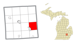
Geography
The township is in the southeastern part of Livingston County and is bordered to the east by Oakland County. The Interstate 96 and U.S. Route 23 cross in the southwest part of the township. I-96 serves the township via exits 147, 150, and 151, while US 23 has access within the township only via I-96. I-96 leads east 43 miles (69 km) to Detroit and west 47 miles (76 km) to Lansing, while US 23 leads north 36 miles (58 km) to Flint and south 17 miles (27 km) to Ann Arbor.
According to the United States Census Bureau, Brighton Township has a total area of 34.6 square miles (89.6 km2), of which 33.0 square miles (85.4 km2) are land and 1.6 square miles (4.2 km2), or 4.69%, are water. [6] Streams in the township flow west and southwest and are part of the Huron River watershed leading to Lake Erie.
General Motors' Milford Proving Ground is in the northeast part of the township.
Demographics
As of the census [1] of 2000, there were 17,673 people, 5,950 households, and 5,015 families residing in the township. The population density was 533.7 inhabitants per square mile (206.1/km2). There were 6,177 housing units at an average density of 186.5 per square mile (72.0/km2). The racial makeup of the township was 97.29% White, 0.43% African American, 0.29% Native American, 0.83% Asian, 0.04% Pacific Islander, 0.31% from other races, and 0.81% from two or more races. Hispanic or Latino of any race were 1.22% of the population. More than 70% of the residents claim Polish, Irish, English or German ancestry. Another 15% claim Portuguese ancestry.
There were 5,950 households, out of which 42.9% had children under the age of 18 living with them, 76.0% were married couples living together, 5.4% had a female householder with no husband present, and 15.7% were non-families. 12.7% of all households were made up of individuals, and 3.7% had someone living alone who was 65 years of age or older. The average household size was 2.96 and the average family size was 3.25. The median Brighton Township home was worth $255,100 and over 66% of the homes are assessed between $200,000 to $500,000. About 17.6% of the population have no mortgage nor rent payment [7] and 60% of local residents spend less than 25% of household income on housing and housing-related expenses.
In the township, the population distribution was spaced with 30.0% under the age of 18, 6.0% from 18 to 24, 29.6% from 25 to 44, 27.7% from 45 to 64, and 6.7% who were 65 years of age or older with the median age at 38 years. For every 100 females age 18 and over, there were 103.2 males.
The median income for a household in the township for 2010 was $93,327, and the median income for a family was $99,680. [8] Males had a median income of $64,775 versus $33,328 for females. The per capita income for the township was $38,151. About 1.8% of families and 2.5% of the population were below the poverty line, including 2.9% of those under age 18 and 2.8% of those age 65 or over.
This page is based on this
Wikipedia article Text is available under the
CC BY-SA 4.0 license; additional terms may apply.
Images, videos and audio are available under their respective licenses.