Browns Island (New Zealand)

Last updated
Browns Island
Motukorea ( Māori )
East Auckland and Rangitoto 10 March 2005.jpg
Browns Island at the centre right of this aerial photo
Geography
Location Hauraki Gulf
Coordinates 36°49′50″S174°53′41″E / 36.8306°S 174.8948°E / -36.8306; 174.8948
Highest elevation68 m (223 ft)
Administration
New Zealand

Browns Island or Motukorea is a small New Zealand island, in the Hauraki Gulf north of Musick Point, one of the best preserved volcanoes in the Auckland volcanic field. The age of eruption is currently unknown. Due to centuries of cultivation, little native bush remains except on the north-eastern cliffs, leaving the volcanic landforms easily visible. It exhibits the landforms from three styles of eruption. The island consists of one main scoria cone with a deep crater, a small remnant arc of the tuff ring forming the cliffs in the northeast, and the upper portions of lava flows. The area was dry land when the eruptions occurred, but much of the lava is now submerged beneath the sea. Coordinates: 36°49′50″S174°53′41″E / 36.8306°S 174.8948°E / -36.8306; 174.8948

Contents

Browns Island crater. Browns Island crater Auckland.jpg
Browns Island crater.
Browns Island from the west. Browns Island.jpg
Browns Island from the west.

History

Maori occupation

The history of Motukorea prior to European arrival is not well documented, and while many of the sources available speculate as to the origins of Ngāti Tamaterā mana whenua and their right to sell the island in 1840, few dispute it. Phillips makes mention of the Tainui canoe stopping at the island after leaving Wakatiwai on the Firth of Thames, before proceeding to Rangitoto where she met up with the Arawa canoe. [1]

In the intervening years, the general area came to be controlled by Ngāti Paoa and the lands to the west were controlled by Ngāti Whātua, but the island remained under the control of Ngāti Tamaterā. Opinion is divided as to why this may be, Phillips postulates that mana may have been vested in return for assistance in battle, [2] whereas Monin regards the occupation and sale of Motukorea as evidence of more widespread penetration of the inner Gulf by numerous Hauraki iwi and hapu. [3]

Motukorea's location at the mouth of the Tamaki River was certainly important as it effectively controlled access up the river, and as a result the Otahuhu and nearby Karetu portage through to the Manukau Harbour. The archaeological remains suggest Motukorea was intensively occupied in pre-European times, with people engaged in stone working industry, marine exploitation, gardening of the fertile volcanic soils, and establishing open and defended settlements. Three sites have been identified by Simmons.[ citation needed ] ‘Archaic’ type artifacts found on the island include worked moa bone, and one-piece fishhooks. Exotic stone resources including chert, basalt, argillite and obsidian from both local gulf island sources and as far afield as Coromandel Peninsula and Great Barrier Island. [4] The name Motukorea means "oystercatcher island".

Brown & Campbell

Starting from 1820, early European visitors included Richard Cruise, Samuel Marsden and John Butler, who both traded with Maori for produce. Dumont D’Urville visited the island in 1827 and reported it abandoned, probably on account of the musket wars. [5] [6] [7] Being already abandoned by Ngāti Tamaterā and located a considerable distance from where they were based in Coromandel, Te Kanini of Ngāti Tamaterā and the sub-chiefs Katikati and Ngatai were willing to sell Motukorea when William Brown and Logan Campbell indicated a desire to buy the island on 22 May 1840. Brown and Campbell settled on the western side of the island from 13 August 1840, making it one of the earliest European settlements in the Auckland area. [8] They built a raupo whare and ran pigs on the island, using it as a base from which they aspired to establish and supply the town of Auckland as soon as land was available on the isthmus. [9]

Not long after Brown and Campbell had taken up residence on the island, Ngāti Whātua chief Āpihai Te Kawau gifted it to Captain Hobson in order to entice him to select Auckland as the new capital for the colony. [10] A flagpole was to be erected on the summit and the island claimed for the Crown, but upon hearing what was transpiring, Brown and Campbell returned to their island and protested their right to occupy the island. The idea was abandoned, but Governor Hobson refused the application for a Crown grant made by Brown in August 1840. The official reason for the refusal was that Brown and Campbell's purchase was made after Sir George Gipps' 1840 proclamation forbidding direct land purchases from the Maori. It was not until Robert FitzRoy assumed the role of governor in 1843 that Brown and Campbell's fortunes changed. The grant was officially made on 22 October 1844. [11] [12]

Campbell left the island in December 1840 to set up a trading business in the newly established settlement of Auckland, [13] [14] while Brown remained on the island until February the following year to manage the pig farm, and likely to watch over their vested interest in the island. In 1856 both men left the colony for Great Britain, appointing a resident manager in charge of their affairs. Campbell eventually bought out Brown's share in their business, including Motukorea, in May 1873 for £40,000 when Brown refused to return from Britain to resume control of their affairs. This transaction was carried out via William Baker who appears to have acted as an intermediary, receiving Brown's share for two days while the transaction was being carried out. In 1877 Campbell proposed to transplant olive trees to Motukorea and 5000 seedlings were grown in a nursery on One Tree Hill for this purpose, but were never transplanted. [15] Campbell eventually sold the island to the Featherstone family in 1879, who built a larger house on the north-eastern side of the island which burnt down in 1915. [16] The derelict house was still on the island until the 1960s.

Abandoned paddle steamers and picnickers at Brown's Island in a 1908 postcard. Browns island 1908 postcard with ferries.jpg
Abandoned paddle steamers and picnickers at Brown's Island in a 1908 postcard.

Devonport Steam Ferry Company

In 1906 the island was sold to the Alison family who operated the Devonport Steam Ferry Company, and during their ownership the hulks of 4 coal powered low draught paddle steamers were abandoned on the low western end of the island. [17] [18] Browns Island is also significant in aviation history, with the Barnard brothers of Auckland carrying out what may have been New Zealand's first glider flights from the upper slopes of the cone in June 1909. [19] In the 1920s the Devonport Steam Ferry Company regularly brought picnickers to the island landing them on a substantial wooden wharf about 120 ft long on the north side of the island. [20] A 1922 survey plan shows a cottage in on the north western flat presumably built to replace the one that was lost in 1915.

Public ownership

The Auckland Metropolitan Drainage Board purchased the island in 1946 proposing to build a sewage treatment plant. Controversy surrounding the proposal forced the plan to be abandoned and the island was eventually purchased by Sir Ernest Davis, who presented it as a gift to the people of Auckland in July 1955. [21] Ernest Davis had been the chairperson of the Devonport Steam Ferry Company for 20 years which may further explain some of his affinity with Browns Island. [22] The Auckland City Council administered the island until 1968 when it became part of the Hauraki Gulf Maritime Park. [23] Management control was vested in the Department of Lands and Survey and in 1987 this was transferred to the Department of Conservation. After the demise of the Hauraki Gulf Maritime Park Board in July 1990, the Auckland City Council was again the designated administering body, and passed back the responsibility for management to the Department of Conservation.

In November 2018 a woman became stranded on the island. She was rescued after a fire she lit to attract attention started burning out of control. [24]

Another view from the north. Browns Island In Hauraki Gulf.jpg
Another view from the north.

Features

Browns Island is part of the Hauraki Gulf Maritime Park. There are three pa sites on the island, with the largest occupying the slopes of the main scoria cone. The island's highest point is 68 metres (223 ft) above sea level.

The mineral motukoreaite was discovered in 1977 on the island and named for it. [25]

Access

The island is not served by ferries, so private boats and seaplanes are the only means of access.

There is no wharf or easy access to the island for larger vessels. For small craft the best landing is on the more sheltered northern side of the island where there is a 100 m (328 ft) long beach, backed by a steep cliff. Navigation is difficult as there is a 70 m (230 ft) long rock reef parallel to the beach. The reef is marked by a beacon. Inside the reef there are small isolated rocks but there is sufficient water between them for a small (up to 6 m or 19.7 ft) craft to move. A crew member should be placed in the bow to give instructions to the skipper.

Access to the rest of the island is via a steep, unformed path up the small headland at the north end of the beach. The path is only suited to fit, agile walkers. The flatter areas to the west have very large part submerged mussel beds which extend out 100 m (328 ft) from the shore preventing easy landing.

The closest mainland boat ramps are at Bucklands Beach or Half Moon Bay Marina.

See also

Notes

  1. Phillips, F. L. (1989). Nga Tohu a Tainui. Landmarks of Tainui: Historic Places of the Tainui People. Volume 2. Tohu Publishers.
  2. Phillips 1989:3
  3. Monin 1996:42
  4. Frederickson 1991
  5. Cruise 1824:200-204
  6. Elder 1932:312-313
  7. Wright 1950:156-7
  8. Campbell 1881:229-253
  9. Campbell 1881:239ff
  10. Campbell 1881:300ff
  11. Monin 1996:42-3
  12. Deeds CT 364/284
  13. Campbell 1881:330
  14. Stone 1982:88
  15. Stone 1987:117
  16. Rickard 1985:11
  17. Maffey 1972
  18. Auckland.R Wolfe.p234. Random House.2002. Auckland.
  19. Brassey 1996:3
  20. Auckland. p234.
  21. Bush 1980
  22. Bush, Graham W. A. "Davis, Ernest Hyam 1872-1962". Dictionary of New Zealand Biography . Ministry for Culture and Heritage . Retrieved 10 April 2011.
  23. NZ Gazette 20/6/1968 No.38 p.1035
  24. "Woman stranded on island lit fires, police say". Radio New Zealand. Retrieved 6 September 2020.
  25. "Motukoreaite". Mindat. Retrieved 6 June 2012.

Related Research Articles

Great Barrier Island

Great Barrier Island lies in the outer Hauraki Gulf, New Zealand, 100 kilometres (62 mi) north-east of central Auckland. With an area of 285 square kilometres (110 sq mi) it is the sixth-largest island of New Zealand and fourth-largest in the main chain. Its highest point, Mount Hobson, is 627 metres (2,057 ft) above sea level. The local authority is the Auckland Council.

Iwi are the largest social units in Aotearoa Māori society. The Māori-language word iwi means "people" or "nation", and is often translated as "tribe", or "a confederation of tribes". The word is both singular and plural in the Māori language. Māori use the word rohe to describe the territory or boundaries of iwi.

Tainui is a tribal waka confederation of New Zealand Māori iwi. The Tainui confederation comprises four principal related Māori iwi of the central North Island of New Zealand: Hauraki, Ngāti Maniapoto, Ngāti Raukawa and Waikato. There are other Tainui iwi whose tribal areas lay outside the traditional Tainui boundaries - Ngāi Tai in the Auckland area, Ngati Raukawa, and Ngāti Toa in the Horowhenua, Kapiti region and Ngāti Rārua and Ngāti Koata in the northern South Island.

Rangitoto Island

Rangitoto Island is a volcanic island in the Hauraki Gulf near Auckland, New Zealand. The 5.5 km (3.4 mi) wide island is a symmetrical shield volcano cone, reaching a height of 260 m (850 ft). Rangitoto is the youngest and largest of the approximately 50 volcanoes of the Auckland volcanic field, having formed in an eruption about 600 years ago, and covering an area of 2,311 ha. It is separated from the mainland of Auckland's North Shore by the Rangitoto Channel. Since World War II, it has been linked by a causeway to the much older, non-volcanic Motutapu Island.

The Musket Wars were a series of as many as 3,000 battles and raids fought throughout New Zealand among Māori between 1807 and 1837, after Māori first obtained muskets and then engaged in an intertribal arms race in order to gain territory or seek revenge for past defeats. The battles resulted in the deaths of between 20,000 and 40,000 people and the enslavement of tens of thousands of Māori and significantly altered the rohe, or tribal territorial boundaries, before the imposition of colonial government in the 1840s. The wars are seen as an example of the "fatal impact" of indigenous contact with Europeans.

Tiritiri Matangi Island Island located in the Hauraki Gulf of New Zealand

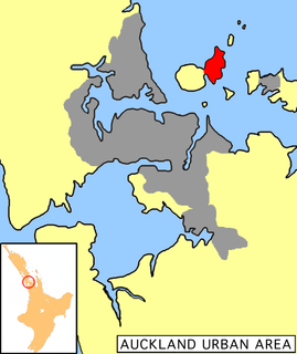
Tiritiri Matangi Island is located in the Hauraki Gulf of New Zealand, 3.4 km (2.1 mi) east of the Whangaparaoa Peninsula in the North Island and 30 km (19 mi) north east of Auckland. The 2.2 km2 (1 sq mi) island is an open nature reserve managed by the Supporters of Tiritiri Matangi Incorporated, under the supervision of the Department of Conservation and is noted for its bird life, including takahē, North Island kōkako and kiwi. It attracts between 30,000 and 32,000 visitors a year, the latter figure being the maximum allowed by the Auckland Conservation Management Strategy.

Ngāti Whātua Māori iwi (tribe) in Aotearoa New Zealand

Ngāti Whātua is a Māori iwi (tribe) of the lower Northland Peninsula of New Zealand's North Island. It comprises a confederation of four hapū (subtribes) interconnected both by ancestry and by association over time: Te Uri-o-Hau, Te Roroa, Te Taoū, and Ngāti Whātua-o-Ōrākei. The four hapū can act together or separately as independent tribes.

Little Barrier Island Island in the Hauraki Gulf, New Zealand

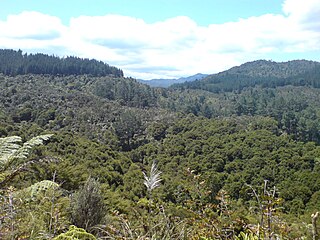
Little Barrier Island, or Hauturu in Māori language, lies off the northeastern coast of New Zealand's North Island. Located 80 kilometres (50 mi) to the north of Auckland, the island is separated from the mainland to the west by Jellicoe Channel, and from the larger Great Barrier Island to the east by Cradock Channel. The two aptly named islands shelter the Hauraki Gulf from many of the storms of the Pacific Ocean.

Motutapu Island Island in the Hauraki Gulf of New Zealand

Motutapu Island is a 1,510 ha island in the Hauraki Gulf to the northeast of the city of Auckland, New Zealand. The island is part of the Hauraki Gulf Maritime Park.

History of Auckland

The human history of the Auckland metropolitan area stretches from early Māori settlers in the 14th century to the first European explorers in the late 18th century, over a short stretch as the official capital of (European-settled) New Zealand in the middle of the 19th century to its current position as the fastest-growing and commercially dominating metropolis of the country.

Fullers Group Limited, trading as Fullers360, is a ferry and tourism company in Auckland, New Zealand. It operates in the Hauraki Gulf and Waitemata Harbour. Fullers Group is the latest in a long line of almost continuous harbour and gulf ferry operations based in Auckland since the 1870s.

William Brown was a 19th-century New Zealand politician, merchant and newspaper proprietor.

Eruera Maihi Patuone

Eruera Maihi Patuone was a Māori rangatira (chief), the son of the Ngāti Hao chief Tapua and his wife Te Kawehau. His exact birth year is not known, but it is estimated that he was at least 108 years old when he died.

Hauraki-Waikato New Zealand parliamentary Māori electorate

Hauraki-Waikato is a New Zealand parliamentary Māori electorate first established for the 2008 election. It largely replaced the Tainui electorate. Nanaia Mahuta of the Labour Party, formerly the MP for Tainui, became MP for Hauraki-Waikato in the 2008 general election and was re-elected in 2011, 2014, 2017 and 2020.

Ngāti Maru (Hauraki) Māori iwi (tribe) in Aotearoa New Zealand

Ngāti Maru is a Māori iwi (tribe) of the Hauraki region of New Zealand. The stronghold of Ngāti Maru has been the Thames area. Ngāti Maru are descendants of Te Ngako, also known as Te Ngakohua, the son of Marutūāhu, after whom the tribe is named.

Ngāti Pāoa Māori iwi (tribe) in Aotearoa New Zealand

Ngāti Pāoa is a Māori iwi (tribe) of the Hauraki region of New Zealand. Its traditional lands stretch from the western side of the Hauraki Plains to Auckland. They also settled on Hauraki Gulf islands such as Waiheke.

Ōtara Suburb in Auckland Council, New Zealand

Ōtara is a suburb of South Auckland, New Zealand, situated 18 kilometres to the southeast of the Auckland CBD. Ōtara lies near the head of the Tamaki River, which extends south towards the Manukau Harbour. Contemporary Ōtara is surrounded by the suburbs of Papatoetoe, East Tāmaki, Clover Park and Flat Bush. The suburb is noted for its proportion of Pacific Islander residents, who make up 78% of the Ōtara population, and its unusually low number of European New Zealanders (Pākehā) residents (10%).

Battle of Hingakaka

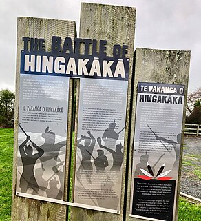
The Battle of Hingakākā was fought between two Maori armies of the North Island, near Te Awamutu and Ōhaupō in the Waikato in the late 18th or early 19th centuries, and was reputedly "the largest battle ever fought on New Zealand soil". One army was from the south of North Island and the other was from the Tainui confederation of central North Island. Both armies included allied forces from several different hapū and iwi.

Ngāti Rongoū

Ngāti Rongoū is a Māori iwi (tribe) of the Coromandel Peninsula in New Zealand.

Karaka Bay (Auckland)

Karaka Bay or Waiarohe is on the western shore of the Tāmaki River mouth in the suburb of Glendowie, Auckland. The bay is bordered to the north by Te Papa a Tamatera and looks out to the islands of the eastern Waitematā Harbour: Rangitoto, Motutapu, Motukorea, Motuihe and Waiheke as well as to Musick Point across the estuary. It is accessed by boat or by a steep path that winds down the hill from the end of Peacock Street; there is no road access to the bay itself. This lack of road access has given Karaka Bay a unique sense of identity; it is unlike anywhere else in Auckland.

References