Brundage, Texas

Last updated

Brundage, Texas
TXMap-doton-Brundage.PNG
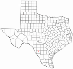
Location of Brundage, Texas
Dimmit County Brundage.svg
Coordinates: 28°35′43″N99°39′45″W / 28.59528°N 99.66250°W / 28.59528; -99.66250
Country United States
State Texas
County Dimmit
Area
  Total0.6 sq mi (1.6 km2)
  Land0.6 sq mi (1.6 km2)
  Water0.0 sq mi (0.0 km2)
Elevation
[1]
535 ft (163 m)
Population
 (2020)
  Total12
  Density19/sq mi (7.5/km2)
Time zone UTC-6 (Central (CST))
  Summer (DST) UTC-5 (CDT)
ZIP code
78834
Area code 830
FIPS code 48-10852 [2]
GNIS feature ID1353013 [1]

Brundage is an unincorporated community and census-designated place (CDP) in Dimmit County, Texas, United States. The population was 12 at the 2020 census.

Contents

Geography

Brundage is located in northeastern Dimmit County at 28°35′43″N99°39′45″W / 28.59528°N 99.66250°W / 28.59528; -99.66250 (28.595243, -99.662611). [3] Texas State Highway 85 passes through the community, leading west 12 miles (19 km) to Carrizo Springs, the county seat, and east 6 miles (10 km) to Big Wells.

According to the United States Census Bureau, the CDP has a total area of 0.62 square miles (1.6 km2), all land. [4]

Demographics

Historical population
CensusPop.Note
2000 31
2010 27−12.9%
2020 12−55.6%
US Decennial Census [3]
2020 Census [5]

As of the census [2] of 2000, there were 31 people, 7 households, and 5 families residing in the CDP. The population density was 1.3 people per square mile (0.5/km2). There were 14 housing units at an average density of 0.6/sq mi (0.2/km2). The racial makeup of the CDP was 67.74% White, 29.03% from other races, and 3.23% from two or more races. Hispanic or Latino of any race were 80.65% of the population.

There were 7 households, out of which 14.3% had children under the age of 18 living with them, 42.9% were married couples living together, 28.6% had a female householder with no husband present, and 14.3% were non-families. 14.3% of all households were made up of individuals, and none had someone living alone who was 65 years of age or older. The average household size was 4.43 and the average family size was 5.00.

In the CDP, the population was spread out, with 38.7% under the age of 18, 12.9% from 18 to 24, 22.6% from 25 to 44, 22.6% from 45 to 64, and 3.2% who were 65 years of age or older. The median age was 22 years. For every 100 females, there were 93.8 males. For every 100 females age 18 and over, there were 137.5 males.

The median income for a household in the CDP was $13,750, and the median income for a family was $13,750. Males had a median income of $0 versus $0 for females. The per capita income for the CDP was $2,371. There were 100.0% of families and 100.0% of the population living below the poverty line, including 100.0% of under 18 and none of those over 65.
Education

The CDP is served by the Carrizo Springs Consolidated Independent School District.

Related Research Articles

<span class="mw-page-title-main">Dimmit County, Texas</span> County in Texas, United States

Dimmit County is a county located in the U.S. state of Texas. As of the 2020 census, its population was 8,615. The county seat is Carrizo Springs. The county was founded in 1858 and later organized in 1880. It is named after Philip Dimmitt, a major figure in the Texas Revolution. The spelling of the county name and the individual's name differ because of a spelling error in the bill creating the county name.

<span class="mw-page-title-main">Dot Lake, Alaska</span> CDP in Alaska, United States

Dot Lake is a census-designated place (CDP) in Southeast Fairbanks Census Area, Alaska, United States. It is located on the Alaska Highway between Delta Junction and Tok. The population was 13 at the 2010 census, down from 19 in 2000.

<span class="mw-page-title-main">Derby Acres, California</span> Census-designated place in California, United States

Derby Acres is a census-designated place (CDP) in Kern County, California, United States. Derby Acres is located 5.5 miles (8.9 km) north-northwest of Fellows, at an elevation of 1,375 feet (419 m). The population was 322 at the 2010 census, down from 376 at the 2000 census. The town is on State Route 33 at the northern extremity of the Midway-Sunset Oil Field, about five miles (8 km)five miles southeast of McKittrick.

<span class="mw-page-title-main">Huerfano, New Mexico</span> CDP in New Mexico, United States

Huerfano is a census-designated place (CDP) in San Juan County, New Mexico, United States. The population was 104 at the 2000 census. It is part of the Farmington Metropolitan Statistical Area. Huerfano is named after El Huerfano Mountain, located a mile to the northeast.

<span class="mw-page-title-main">East Dunseith, North Dakota</span> CDP in North Dakota, United States

East Dunseith is a census-designated place (CDP) in Rolette County, North Dakota, United States. The population was 500 at the 2020 census.

Duchess Landing is a census-designated place (CDP) in McIntosh County, Oklahoma, United States. The population was 157 at the 2020 census.

<span class="mw-page-title-main">Reedsville, Pennsylvania</span> Census-designated place in Pennsylvania, United States

Reedsville is a census-designated place (CDP) in the Kishacoquillas Valley of Mifflin County, Pennsylvania, United States. The population was 641 at the 2010 census. Reedsville has a high Amish population.

<span class="mw-page-title-main">Flowella, Texas</span> Census-designated place in Texas, United States

Flowella is a census-designated place (CDP) in Brooks County, Texas, United States. The population was 117 at the 2020 census.

<span class="mw-page-title-main">Asherton, Texas</span> City in Texas, United States

Asherton is a city in Dimmit County, Texas, United States. The population was 722 at the 2020 census, down from 1,084 at the 2010 census. U.S. Highway 83 passes through Asherton.

Big Wells is a city in Dimmit County, Texas, United States. The population was 483 at the 2020 census, down from 697 at the 2010 census.

<span class="mw-page-title-main">Carrizo Hill, Texas</span> CDP in Texas, United States

Carrizo Hill is a census-designated place (CDP) in Dimmit County, in the U.S. state of Texas, United States. The population was 550 at the 2020 census.

<span class="mw-page-title-main">Carrizo Springs, Texas</span> City in Texas, United States

Carrizo Springs is the largest city in and the county seat of Dimmit County, Texas, United States. The population was 4,892 at the 2020 census, down from 5,368 at the 2010 census.

<span class="mw-page-title-main">Catarina, Texas</span> CDP in Texas, United States

Catarina is a census-designated place (CDP) in Dimmit County, Texas, United States. The population was 70 at the 2020 census. The community has no U.S. Post Office.

<span class="mw-page-title-main">Morning Glory, Texas</span> Census-designated place in Texas, United States

Morning Glory is a census-designated place (CDP) in El Paso County, Texas, United States. The population was 522 at the 2020 census, down from 651 at the 2010 census. It is part of the El Paso Metropolitan Statistical Area. The ZIP Code encompassing the CDP area is 79836.

<span class="mw-page-title-main">Chula Vista, Maverick County, Texas</span> CDP in Texas, United States

Chula Vista, formerly known as Rosita North, is a census-designated place (CDP) in Maverick County, Texas, United States. The population was 5,100 at the 2020 census.

<span class="mw-page-title-main">Falman-County Acres, Texas</span> Former CDP in Texas, United States

Falman-County Acres is a census-designated place (CDP) in San Patricio County, Texas, United States. The population was 289 at the 2000 census.

<span class="mw-page-title-main">El Refugio, Texas</span> CDP in Texas, United States

El Refugio is a census-designated place (CDP) in Starr County, Texas, United States. The population was 407 at the 2020 census. El Refugio gained area in the 2010 census.

<span class="mw-page-title-main">Windemere, Texas</span> Former CDP in Texas, United States

Windermere is a former census-designated place (CDP) in Travis County, Texas, United States. The population was 1,037 at the 2010 census. It has since largely been annexed by the city of Pflugerville.

Larga Vista is a former census-designated place (CDP) in Webb County, Texas, United States. The population was 742 at the 2000 census. Larga Vista lost its census-designated place status in 2010 because it became surrounded by Laredo. A CDP may not be located, either partially or entirely, within an incorporated place or another CDP. Today, Larga Vista is considered a Laredo neighborhood.

<span class="mw-page-title-main">Santa Monica, Texas</span> CDP in Texas, United States

Santa Monica is a census-designated place (CDP) in Willacy County, Texas, United States. The population was 86 at the 2020 census.

References

  1. 1 2 U.S. Geological Survey Geographic Names Information System: Brundage, Texas
  2. 1 2 "U.S. Census website". United States Census Bureau . Retrieved January 31, 2008.
  3. 1 2 "US Gazetteer files: 2010, 2000, and 1990". United States Census Bureau. February 12, 2011. Retrieved April 23, 2011.
  4. "Geographic Identifiers: 2010 Demographic Profile Data (G001): Brundage CDP, Texas". American Factfinder. U.S. Census Bureau. Archived from the original on February 13, 2020. Retrieved January 8, 2016.
  5. "Census Bureau profile: Brundage, Texas". United States Census Bureau. May 2023. Retrieved June 9, 2024.