Bubanj Potok

Last updated • 5 min readFrom Wikipedia, The Free Encyclopedia
Bubanj Potok
Бубањ Поток
Location map Belgrade Central.png
Red pog.svg
Bubanj Potok
Location of Bubanj Potok within Belgrade
Coordinates: 44°43′13″N20°32′29″E / 44.72028°N 20.54139°E / 44.72028; 20.54139 Coordinates: 44°43′13″N20°32′29″E / 44.72028°N 20.54139°E / 44.72028; 20.54139
Country Flag of Serbia.svg Serbia
Region Flag of Belgrade, Serbia.svg Belgrade
Municipality Voždovac
Time zone UTC+1 (CET)
  Summer (DST) UTC+2 (CEST)
Area code +381(0)11
Car plates BG

Bubanj Potok (Serbian Cyrillic : Бубањ Поток) is a non-residential suburban settlement of Belgrade, the capital of Serbia. It is located in Belgrade's municipality of Voždovac.

Contents

Location

Bubanj Potok is located on the highway Belgrade–Niš, in the valley of the same name, a section of the valley of the Bolečica river, where many smaller creeks, some of them intermittent, flow into the Bolečica: Bubanj Potok, Zavojnička reka, Vranovac, Kamena voda, Gleđevac, etc. East of the valley is Leštane, municipality of Grocka, while Beli Potok on the west, mountain Avala on the southwest and Zuce on the south, are in the municipality of Voždovac. The southernmost tip of Zvezdara municipality is just north of it. [1]

Characteristics

Bubanj Potok is named after the creek of the same name and means "drum creek" in Serbian. It is a non-residential settlement which spawns around the crossroads of the highway and the Kružni put, the major road connecting the settlements on the southern outskirts of Belgrade. Major facilities in the settlement include:

Military complex

Vast complex of the military barracks and the training shooting ground "Bubanj Potok" was heavily bombed and largely destroyed in the 1999 NATO bombing of Serbia. Construction of the complex originally began in 1966, during the Youth work action "Bubanj Potok 66", but was expanded in later years. Some 5,000 youth workers participated in the construction. [2] [3]

IKEA store

Major changes, including the displacement of the toll houses which were synonymous for Bubanj Potok for decades, started in April 2016 when the construction of an IKEA store began. Over 2,300 piles were drilled deep into the ground, over 300.000 m3 (10,594.4 cu ft) of material was poured to fill the construction site, old roads have been displaced and the new access roads have been constructed, power lines were elevated to a higher level and 2.2 km (1.4 mi) of the Zavojnička reka (upper section of the Bolečica river) have been regulated. The building, which should cover an area of 36,000 m2 (390,000 sq ft), will use the green technologies: geothermal springs, solar panels, LED lights, electric cars' chargers and the work of art systems for the disposal of garbage and waste water purification. A special bus will connect the city with the store and the talks are in progress between IKEA and the Belgrade's city transportation company, GSP Belgrade, for the new public bus line (currently, bus line 306 which goes to Leštane, only intermittently drives to Bubanj Potok). It will be the first IKEA store in Serbia and one of the largest in the region. As the store and the adjoining parking, with the 1,375 parking spots, will cover a lot of 12 ha (30 acres), while IKEA bought a neighboring lot of 19 ha (47 acres), too, future expansion is probable. [4]

The store was opened on 10 August 2017. It was announced that it will sell 9,500 products, of which only 2 will be actually made in Serbia: wooden cutting boards and rolling pins and the prices will correspond to those "in the region", though the average salaries in Serbia are lower. Ceremonial opening was attended by the President of Serbia Aleksandar Vučić, government ministers and the mayor of Belgrade Siniša Mali. A new public transportation bus line No. 70 was formed just for the store, as it is located outside of the urban area of Belgrade. [5] [6]

Toll booths Bubanj Potok

Built in the 1970s, the toll booths Bubanj Potok, for decades marked the entrance into the Belgrade from the Niš direction. On 13 April 2017 toll booth became defunct as the new one, Vrčin, further down toward Niš was open for traffic. [7] The toll booths were completely demolished in August 2017. [8]

Transportation

Bubanj Potok is known for its traffic importance. Apart from the existing large interchange on the highway, crossroad with the Kružni put and former toll booths, it is projected as the future crossroad of the Belgrade bypass and accompanying railroad, both of which would proceed directly from here to the future Vinča-Omoljica Bridge across the Danube, to Pančevo. As for the bypass itself, Bubanj Potok is the marking point between its two projected sections, Ostružnica-Bubanj Potok and Bubanj Potok-Vinča. The section from Ostružnica will be 19.5 km (12.1 mi) long and the Minister for transportation, Zorana Mihajlović announced that works will begin in August 2018, with a deadline in 2020. The final section, to Vinča, still has no set dates. A planned, 1.3-kilometre-long (4,265 ft) "Bubanj Potok" tunnel is part of the project. [9]

The highway section through the area is known for the accidents. The section is built as the narrowing curve on the downhill slope, with both ascending and descending angles being 7%, which is deemed too much for highway. The curve has a radius of 300 metres (980 ft) which makes it the largest bend between Belgrade and Niš. Several solutions were proposed to fix the problem. They include reducing the allowed speed in this section to 80 kilometres per hour (50 mph), reconstruction of the curve which would enlarge the cross-section inclination, and relocation of the narrowing (from three lanes into two lanes and one shoulder) further away from the curve. The best proposed fix, however, is a tunnel, which would be less than a kilometre long. When the highway was planned in the early 1970s, the engineers were aware of the problem and proposed the tunnel, but the idea was dropped. [10]

Related Research Articles

Kaluđerica Urban neighbourhood in Grocka, Belgrade, Serbia

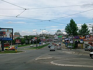
Kaluđerica is an urban neighborhood of Belgrade, Serbia. It is located in the municipality of Grocka.

Avala Mountain in Serbia

Avala is a mountain in Serbia, overlooking Belgrade. It is situated in the south-eastern corner of the city and provides a great panoramic view of Belgrade, Vojvodina and Šumadija, as the surrounding area on all sides is mostly lowlands. It stands at 511 metres (1,677 ft) above sea level, which means that it enters the locally defined mountain category just by 11 m (36 ft).

Voždovac Municipality in Belgrade, Serbia

Voždovac is a municipality of the city of Belgrade. According to the 2011 census results, the municipality has a population of 158,213 inhabitants.

Zvezdara Municipality in Belgrade, Serbia

Zvezdara is a municipality of the city of Belgrade. The municipality is geographically hilly and with many forests. According to the 2011 census results, the municipality has a population of 148,014 inhabitants.

Resnik, Belgrade Urban neighbourhood in Rakovica, Belgrade, Serbia

Resnik is an urban neighborhood of Belgrade, Serbia. It is located in Belgrade's municipality of Rakovica.

Autokomanda Urban neighbourhood in Voždovac, Belgrade, Serbia

Autokomanda is an urban neighborhood of Belgrade, the capital of Serbia. It is located on the tripoint of the Belgrade's municipalities of Voždovac, Savski Venac and Vračar.

Leštane is a suburban settlement of Belgrade, Serbia. It is located in the municipality of Grocka.

Vinča Suburban settlement in Grocka, Belgrade, Serbia

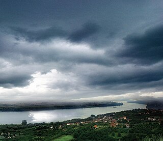
Vinča is a suburban settlement of Belgrade, Serbia. It is part of the municipality of Grocka. Vinča-Belo Brdo, an important archaeological site that gives its name to the Neolithic Vinča culture, is located in the village.

Beli Potok (Belgrade) Town in City of Belgrade, Serbia

Beli Potok is a small town and a suburban settlement of Belgrade, Serbia. It is located in Belgrade's municipality of Voždovac.

Subdivisions of Belgrade Place

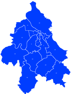
Serbia's capital city of Belgrade is divided into 17 municipalities.

Topčiderka

Topčiderska River, or colloquially Topčiderka, or Topčiderski Creek, is a river in north-central Serbia, a 30 km-long right tributary to the Sava river to which it flows in the urban section of Belgrade. It is one of the 40 rivers, streams and creeks that flow or used to flow through Belgrade.

Kumodraž is an urban neighborhood of Belgrade, Serbia. It is located in Belgrade's municipality of Voždovac.

Marinkova Bara Urban neighbourhood in Voždovac, Belgrade, Serbia

Marinkova Bara is an urban neighborhood of Belgrade, the capital of Serbia. It is located in the municipality of Voždovac.

Stepin Lug

Stepin Lug or Gaj is a park-forest and, for the most part, non-residential suburban settlement of Belgrade, the capital of Serbia. It is located in Belgrade's municipalities of Voždovac and Zvezdara. It is part of the forest complex Stepin Lug-Baba Velka-Torlak-Jajinci, which is the largest wooden area in Belgrade.

Zuce Suburban settlement in Serbia

Zuce is a suburban settlement of Belgrade, Serbia. It is located in Belgrade's municipality of Voždovac.

Bolečica

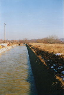
The Bolečica is a short river in north-central Serbia, a 12 km-long right tributary to the Danube. During its entire flow it runs through the suburban section of Belgrade and despite being short it flows through the three Belgrade's municipalities, next to the half dozen of suburbs of Belgrade with a total population of 35,000 and is a route to important roads.

A1 motorway (Serbia)

The A1 motorway is a motorway in Serbia and at 588 kilometers (365 mi) it is the longest motorway in Serbia. It crosses the country from north to south, starting at the Horgoš border crossing with Hungary and ending at the Preševo border crossing with North Macedonia. As a part of the European route E75 and Pan-European corridor X, connecting 4 of 5 largest Serbian cities, it is the most vital part of the Serbian road network.

The Belgrade railway junction is a large-scale reconstruction of the rail network in Belgrade, Serbia. It was launched 1971 with works officially starting 1974 with the construction of the New Railway Bridge. The central part of the scheme is formed by the Belgrade Centre railway station, better known as Prokop after the neighborhood it is located in, which is served via three tunnels beneath the city center.

Yuri Gagarin Street, Belgrade

Yuri Gagarin Street is a major street in New Belgrade, named after Soviet cosmonaut Yuri Gagarin, the first man in space.

Bridges of Belgrade

Belgrade, the capital of Serbia, is located on two major rivers, the Danube and the Sava which are spanned by 11 bridges in total.

References

  1. Slobodan Radovanović (2007). Belgrade and surrounding places. Smederevska Palanka: Magic Map. ISBN   978-86-7802-004-9.
  2. Milorad Kozlovački (1 April 2022). "Omladina Zemuna na radnim akcijama" [Zemun's youth at work actions]. Politika (in Serbian). p. 21.
  3. Aleksandar Ćirić (1999). "Bubanj potok". War-time Vreme, No. 13 (in Serbian).
  4. Dejan Aleksić (19 March 2017). "Majstori dve nedelje ispred roka" (in Serbian). Politika.
  5. Dejan Aleksić (9 August 2017), "Kvalitet robe kao u Švedskoj, cene kao u region", Politika (in Serbian), p. 09
  6. Beta (10 August 2017). "Otvorena prva Ikea u Srbiji" (in Serbian). N1.
  7. Dejan Aleksić (12 April 2017). "Od sutra naplata putarine na rampi Beograd kod Vrčina". Politikallanguage=Serbian.
  8. Dejan Aleksić (7 July 2017), "Završni radovi na "Ikeinom" placu", Politika (in Serbian), p. 16
  9. Dejan Aleksić (27 January 2018). "Radovi na obilaznici kod Voždovca od 1. februara" [Works on the bypass at Voždovac from 1. February]. Politika (in Serbian). p. 15.
  10. Ljubiša Stanojević (24 May 2021). "Opasnosti na auto-putu u Bubanj potoku" [Dangers on highway in Bubanj Potok]. Politika (in Serbian). p. 23.