
The Permian Basin is a large sedimentary basin in the southwestern part of the United States. It is the highest producing oil field in the United States, producing an average of 4.2 million barrels of crude oil per day in 2019. This sedimentary basin is located in western Texas and southeastern New Mexico.

The Glen Rose Formation is a shallow marine to shoreline geological formation from the lower Cretaceous period exposed over a large area from South Central to North Central Texas. The formation is most widely known for the dinosaur footprints and trackways found in the Dinosaur Valley State Park near the town of Glen Rose, Texas, southwest of Fort Worth and at other localities in Central Texas.
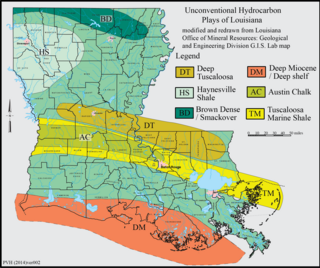
The Haynesville Shale is an informal, popular name for a Jurassic Period rock formation that underlies large parts of southwestern Arkansas, northwest Louisiana, and East Texas. It lies at depths of 10,500 to 13,000 feet below the land’s surface. It is part of a large rock formation which is known by geologists as the Haynesville Formation. The Haynesville Shale underlies an area of about 9,000 square miles and averages about 200 to 300 feet thick. The Haynesville Shale is overlain by sandstone of the Cotton Valley Group and underlain by limestone of the Smackover Formation.

The Muav Limestone is a Cambrian geologic formation within the 5-member Tonto Group. It is a thin-bedded, gray, medium to fine-grained, mottled dolomite; coarse- to medium-grained, grayish-white, sandy dolomite and grayish-white, mottled, fine-grained limestone. It also contains beds of shale and intraformational conglomerate. The beds of the Muav Limestone are either structureless or exhibit horizontally laminations and cross-stratification. The Muav Limestone forms cliffs or small ledges that weather a dark gray or rusty-orange color. These cliffs or small ledges directly overlie the sloping surfaces of the Bright Angel Shale. The thickness of this formation decreases eastward from 250 feet (76 m) in the western Grand Canyon to 45 feet (14 m) in the eastern Grand Canyon. To the west in southern Nevada, its thickness increases to 830 feet (250 m) in the Frenchman Mountain region.
The Trinity Group is a group in the Lower Cretaceous lithostratigraphy of Texas, Arkansas, Mississippi, Louisiana and Oklahoma. It is named for the Trinity River of Texas.
The Bone Spring Formation is a geologic formation found in the Delaware Basin in Texas and New Mexico. It preserves fossils dating back to the Leonardian Age of the Permian Period.

The Capitan Formation is a geologic formation found in western Texas and southeastern New Mexico. It is a fossilized reef dating to the Guadalupian Age of the Permian period.
The Cutoff Formation is a geologic formation in Texas and New Mexico, US. It preserves fossils dating back to the Permian period.
The San Andres Formation is a geologic formation found in New Mexico and Texas. It contains fossils characteristic of the late Leonardian (Kungurian) Age) of the Permian Period.

The El Paso Formation is a geologic formation that is exposed from the Permian Basin of New Mexico and Texas to southeastern Arizona. It preserves fossils dating back to the Ordovician period.
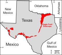
The Eagle Ford Group is a sedimentary rock formation deposited during the Cenomanian and Turonian ages of the Late Cretaceous over much of the modern-day state of Texas. The Eagle Ford is predominantly composed of organic matter-rich fossiliferous marine shales and marls with interbedded thin limestones. It derives its name from outcrops on the banks of the West Fork of the Trinity River near the old community of Eagle Ford, which is now a neighborhood within the city of Dallas. The Eagle Ford outcrop belt trends from the Oklahoma-Texas border southward to San Antonio, westward to the Rio Grande, Big Bend National Park, and the Quitman Mountains of West Texas. It also occurs in the subsurface of East Texas and South Texas, where it is the source rock for oil found in the Woodbine, Austin Chalk, and the Buda Limestone, and is produced unconventionally in South Texas and the "Eaglebine" play of East Texas. The Eagle Ford was one of the most actively drilled targets for unconventional oil and gas in the United States in 2010, but its output had dropped sharply by 2015. By the summer of 2016, Eagle Ford spending had dropped by two-thirds from $30 billion in 2014 to $10 billion, according to an analysis from the research firm Wood Mackenzie. This strike has been the hardest hit of any oil fields in the world. The spending was, however, expected to increase to $11.6 billion in 2017. A full recovery is not expected any time soon.
The Del Norte Formation is a geologic formation in Mexico, New Mexico and Texas near the city of El Paso. It preserves fossils dating back to the early Cretaceous period.

The Finlay Limestone is a geologic formation in western Texas, southern New Mexico, and northern Chihuahua. It preserves fossils dating back to the early Cretaceous period.
The Muleros Formation is a geologic formation in New Mexico, which is particularly well exposed at Cerro de Cristo Rey near El Paso, Texas. It preserves fossils dating back to the early Cretaceous period.
The Rancheria Formation is a geologic formation in the Sacramento and San Andres Mountains of New Mexico, the Franklin Mountains of southern New Mexico and western Texas, and the Hueco Mountains of western Texas. It preserves fossils dating back to the Visean Age of the Mississippian.
The Queen Formation is a geologic formation in southeastern New Mexico and west Texas. It preserves fossils dating back to the late Guadalupian Epoch of the Permian period.
The Castile Formation is a geologic formation in west Texas and southeastern New Mexico, United States. It was deposited in the Ochoan Stage of the Permian period.
The Allamoore Formation is a Precambrian geologic formation found in the vicinity of Van Horn, Texas. The formation is notable for the well-preserved microfossils found in chert beds within the formation. These may include early eukaryotes. Possible fossil burrows were reported in the formation in 1995, which would push the origin of the first animals (Metazoa) back to before 1000 million years ago. However, these have since been explained as diagenetic structures, formed by nonbiological processes as the sediments making up the formation were compacted and lithified.
The Canutillo Formation is a geologic formation that is exposed in the Franklin Mountains near El Paso, Texas. The formation is Middle Devonian in age.
The Goat Seep Formation is a geologic formation found in western Texas and southeastern New Mexico. It is a fossilized reef dating to the Guadalupian Age of the Permian period.


