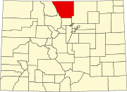
Larimer County is one of the 64 counties in the U.S. state of Colorado. As of the 2010 census, the population was 299,630. The county seat and most populous city is Fort Collins. The county was named for William Larimer, Jr., the founder of Denver.

Jackson County is a county in the state of Colorado. As of the 2010 census, the population was 1,394, and it was the fourth least-densely populated in the state. The county seat and only municipality in the county is Walden.

Grand County is one of the 64 counties in the U.S. state of Colorado. As of the 2010 census, the population was 14,843. The county seat is Hot Sulphur Springs.

Horsetooth Mountain is a mountain summit in the foothills of the Front Range of the Rocky Mountains of North America. The 7,259-foot (2,213 m) peak is located in the Horsetooth Mountain Open Space, 7.0 miles (11.2 km) west of downtown Fort Collins in Larimer County, Colorado, United States.
William Larimer Jr. was a Kansas state senator, American settler, and land developer who is best known as the founder of Denver, Colorado in 1858. Larimer often went by "General Larimer", having acquired the title in the Pennsylvania Militia.

Mummy Mountain is a high mountain summit in the Mummy Range of the Rocky Mountains of North America. The 13,430-foot (4,093 m) thirteener is located in the Rocky Mountain National Park, 8.5 miles (13.7 km) northwest by north of the Town of Estes Park in Larimer County, Colorado, United States.

The Budweiser Events Center is a 7,200-seat multi-purpose arena in Loveland, Colorado, United States. The Arena is located on The Ranch and is owned by Larimer County, Colorado and managed by Global Spectrum, L.P., and tickets are handled by ComcastTIX.

Colorado's 2nd Congressional District is a congressional district in the U.S. state of Colorado. The district is located in the north-central part of the state and encompasses the northwestern suburbs of Denver including Boulder, Northglenn, Thornton, and Westminster. The district also includes the mountain towns of Vail, Grand Lake and Idaho Springs. Redistricting in 2011 has moved Larimer County, including the cities of Fort Collins and Loveland, to the 2nd from the 4th district for the 2012 election.

There are more than 1,500 properties and historic districts in Colorado listed on the National Register of Historic Places. They are distributed over 63 of Colorado's 64 counties; only Broomfield County has none.

Drake is an unincorporated community in Larimer County, Colorado located in the Big Thompson Canyon between Estes Park, Colorado and Loveland, Colorado near Rocky Mountain National Park. A U.S. Post Office is also situated in the county ZIP Code 80515. The 2010 population of Drake was 1,010.

The Twin Sisters Peaks are mountains in Colorado, located in the Front Range in Larimer County, Colorado, straddling Rocky Mountain National Park and Roosevelt National Forest.

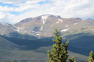
Hagues Peak is the highest summit of the Mummy Range in the Rocky Mountains of North America. The 13,573-foot (4,137 m) thirteener is located in the Rocky Mountain National Park Wilderness, 9.9 miles (15.9 km) northwest of the Town of Estes Park, Colorado, United States. The summit of Hagues Peak is the highest point in Larimer County, Colorado.

Rustic is an unincorporated community in Larimer County, Colorado, United States. Rustic is located on State Highway 14 and the Cache La Poudre River 27.3 miles (43.9 km) west-northwest of Fort Collins. The community borders Glen Echo to the west.
Fairchild Mountain is a high mountain summit in the Mummy Range of the Rocky Mountains of North America. The 13,508-foot (4,117 m) thirteener is located in the Rocky Mountain National Park Wilderness, 9.6 miles (15.5 km) northwest of the Town of Estes Park in Larimer County, Colorado, United States.

Mount Chiquita is a mountain summit in the Mummy Range of the Rocky Mountains of North America. The 13,075-foot (3,985 m) thirteener is located in Rocky Mountain National Park, 9.8 miles (15.7 km) northwest by west of the Town of Estes Park in Larimer County, Colorado, United States.
Greyrock Mountain is a mountain summit in the Laramie Mountains range of the Rocky Mountains of North America. The 7,616-foot (2,321 m) peak is located in Roosevelt National Forest, 1.2 miles (1.9 km) north-northeast of the community Poudre Park in Larimer County, Colorado, United States.
Mount McConnel is a mountain summit in the Mummy Range of the Rocky Mountains of North America. The 8,012-foot (2,442 m) peak is located in the Cache La Poudre Wilderness of Roosevelt National Forest, 22.7 miles (36.5 km) west-northwest of the City of Fort Collins in Larimer County, Colorado, United States. The summit can be reached via the Mount McConnel National Recreation Trail.

Iron Mountain is a mountain summit in the Never Summer Mountains of the Rocky Mountains of North America. The 12,270-foot (3,740 m) peak is located 2.4 miles (3.8 km) east-southeast of the Cameron Pass, Colorado, United States, on the drainage divide separating State Forest State Park and Jackson County from Roosevelt National Forest and Larimer County.

Mount Ida is a mountain summit in the northern Front Range of the Rocky Mountains of North America. The 12,874-foot (3,924 m) peak is located in the Rocky Mountain National Park Wilderness, 13.4 miles (21.6 km) west of the Town of Estes Park, Colorado, United States, on the Continental Divide between Grand and Larimer counties. The mountain was probably named after Mount Ida on Crete.