Bunch, Oklahoma

Last updated

Bunch
Bunch, Oklahoma.jpg
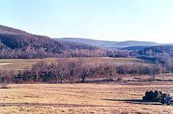
Picture of Bunch almost hidden in the trees from about 1 mile north. There is a Kansas City Southern freight-train just across the road
USA Oklahoma location map.svg
Red pog.svg
Bunch
Location within the state of Oklahoma
Usa edcp location map.svg
Red pog.svg
Bunch
Bunch (the United States)
Coordinates: 35°40′57″N94°45′38″W / 35.68250°N 94.76056°W / 35.68250; -94.76056
Country United States
State Oklahoma
County Adair
Area
[1]
  Total15.39 sq mi (39.85 km2)
  Land15.27 sq mi (39.55 km2)
  Water0.11 sq mi (0.29 km2)
Elevation
781 ft (238 m)
Population
 (2020)
  Total70
  Density4.58/sq mi (1.77/km2)
Time zone UTC-6 (Central (CST))
  Summer (DST) UTC-5 (CDT)
ZIP codes
74931
FIPS code 40-09900
GNIS feature ID1100245 [2]

Bunch is an unincorporated community in southwestern Adair County, Oklahoma, United States. [2] It was named after a Cherokee vice-chief named Rabbit Bunch who lived in the area in the 1880s.[ citation needed ] Nestled in the Sallisaw Creek valley, Bunch is bisected by the Kansas City Southern Railroad, which was built in the 1890s. Bunch is in the Cookson Hills area of eastern Oklahoma which are a part of the western area of the Ozark Mountains. The Cookson Hills Wildlife Management Area is west of the town. [3] The post office's zip code is 74931.[ citation needed ] Two and one-half miles north of town is Cave Springs Public Schools, a K-12 school which serves Bunch and the surrounding area.

Contents

Demographics

Historical population
CensusPop.Note
2020 70
U.S. Decennial Census [4]

Bunch is one of the prominent locales referenced in Elmore Leonard's crime novel "The Hot Kid", which takes place in the 1930s.

Related Research Articles

<span class="mw-page-title-main">Sequoyah County, Oklahoma</span> County in Oklahoma, United States

Sequoyah County is a county located in the U.S. state of Oklahoma. As of the 2020 census, the population was 39,281. The county seat is Sallisaw. Sequoyah County was created in 1907 when Oklahoma became a state. It was named after Sequoyah, who created the Cherokee syllabary and its written language.

<span class="mw-page-title-main">Muskogee County, Oklahoma</span> County in Oklahoma, United States

Muskogee County is a county located in the U.S. state of Oklahoma. As of the 2020 census, the population was 66,339. The county seat is Muskogee. The county and city were named for the Muscogee (Creek) Nation. The official spelling of the name was changed to Muskogee by the post office in 1900.

<span class="mw-page-title-main">Cherokee County, Oklahoma</span> County in Oklahoma, United States

Cherokee County is a county located in the U.S. state of Oklahoma. As of the 2020 census, the population was 47,078. Its county seat is Tahlequah, which is also the capital of the Cherokee Nation.

<span class="mw-page-title-main">Adair County, Oklahoma</span> County in Oklahoma, United States

Adair County is a county located in the U.S. state of Oklahoma. As of the 2020 census, the population was 19,495. Its county seat is Stilwell. Adair County was named after the Adair family of the Cherokee tribe. One source says that the county was specifically named for Watt Adair, one of the first Cherokees to settle in the area. Adair County is part of the Cherokee Nation reservation.

<span class="mw-page-title-main">Stilwell, Oklahoma</span> City in Oklahoma, United States

Stilwell / ᏍᏗᎳᏪᎵ is a city located in the sovereign territory of the Cherokee Nation. It is also the county seat of Adair County, Oklahoma. The population was 3,700 as of the 2020 U.S. census, a decline of 6.7 percent from the 3,949 population recorded in 2010. The Oklahoma governor and legislature proclaimed Stilwell as the "Strawberry Capital of the World” in 1949, but the role of strawberries in the local economy has diminished significantly since then. Today, residents of Stilwell are among the poorest and most impoverished in the United States. Stilwell also serves as a gateway to Lake Tenkiller and Adair Park, formerly called Adair State Park before it was defunded.

<span class="mw-page-title-main">Watts, Oklahoma</span> Town in Oklahoma, United States

Watts is a town in northern Adair County, Oklahoma, United States. It was named for John Watts, also known as Young Tassel, a Chickamauga Cherokee chief, who died in 1802. The population was 324 at the 2010 census, an increase of 2.5 percent over the figure of 316 recorded in 2000.

<span class="mw-page-title-main">Westville, Oklahoma</span> Town in Oklahoma, United States

Westville is a town in Adair County, Oklahoma, located in the foothills of the Ozark Mountains. Westville lies at the junction of U.S. Highways 59 and 62, and approximately 13 miles north of Stilwell, the county seat.

<span class="mw-page-title-main">Park Hill, Oklahoma</span> Census-designated place in Oklahoma, United States

Park Hill is an unincorporated community and census-designated place (CDP) in southwestern Cherokee County, Oklahoma, United States. The population was 3,909 at the 2010 census. It lies near Tahlequah, east of the junction of U.S. Route 62 and State Highway 82.

<span class="mw-page-title-main">Tahlequah, Oklahoma</span> City in Oklahoma, United States

Tahlequah is a city in Cherokee County, Oklahoma located at the foothills of the Ozark Mountains. It is part of the Green Country region of Oklahoma and was established as a capital of the 19th-century Cherokee Nation in 1839, as part of the new settlement in Indian Territory after the Cherokee Native Americans were forced west from the American Southeast on the Trail of Tears.

<span class="mw-page-title-main">Poteau, Oklahoma</span> City in Oklahoma, United States

Poteau is a city in, and county seat of, Le Flore County, Oklahoma, United States. The population was 8,520 as of the 2010 census.

<span class="mw-page-title-main">Thackerville, Oklahoma</span> Town in Oklahoma, United States

Thackerville is a town in Love County, Oklahoma, United States. It is located near the Texas state border. The population was 445 at the 2010 census.

<span class="mw-page-title-main">Adair, Oklahoma</span> Town in Oklahoma, United States

Adair is a town in Mayes County, Oklahoma, United States. The population was 790 at the 2010 census, compared to the figure of 704 recorded in 2000. Named for two prominent Cherokee brothers, the town was established in 1883. It opened a Cherokee school.

<span class="mw-page-title-main">Eufaula, Oklahoma</span> City in Oklahoma, United States

Eufaula is a city and county seat of McIntosh County, Oklahoma, United States. The population was 2,813 at the 2010 census, an increase of 6.6 percent from 2,639 in 2000. Eufaula is in the southern part of the county, 30 miles (48 km) north of McAlester and 32 miles (51 km) south of Muskogee.

<span class="mw-page-title-main">Muldrow, Oklahoma</span> Town in Oklahoma, United States

Muldrow is a town in Sequoyah County, Oklahoma, United States. It is part of the Fort Smith, Arkansas-Oklahoma Metropolitan Statistical Area. The population was 3,466 at the 2010 census, an increase of 11.7 percent over the figure of 3,104 recorded in 2000.

<span class="mw-page-title-main">Sallisaw, Oklahoma</span> City in Oklahoma, United States

Sallisaw is a city and county seat in Sequoyah County, Oklahoma, United States. As of the 2010 Census, it had a population of 8,880, an 11.2 percent increase over the figure of 7,891 recorded in 2000. Sallisaw is part of the Fort Smith, Arkansas–Oklahoma Metropolitan Statistical Area.

<span class="mw-page-title-main">Boston Mountains</span> Highland ecoregion in Arkansas and Oklahoma, United States

The Boston Mountains is a Level III ecoregion designated by the Environmental Protection Agency (EPA) in the U.S. states of Arkansas and Oklahoma. Part of the Ozarks, the Boston Mountains are a deeply dissected plateau. The ecoregion is steeper than the adjacent Springfield Plateau to the north, and bordered on the south by the Arkansas Valley. The Oklahoma portion of the range is locally referred to as the Cookson Hills. There are several theories of how the mountains were named, though apparently none are related to the Massachusetts city.

<span class="mw-page-title-main">Green Country</span>

Green Country, sometimes referred to as Northeast Oklahoma, is the northeastern portion of the U.S. state of Oklahoma, which lies west of the northern half of Arkansas, the southwestern corner the way of Missouri, and south of Kansas.

Cookson is a community in the Cookson Hills of Cherokee County, Oklahoma, United States. The post office opened April 11, 1895. The ZIP Code is 74427. It is said to have been named for the first postmaster, John H. Cookson.

<span class="mw-page-title-main">Cherokee Immersion School</span> Cherokee language immersion school in Tahlequah, Oklahoma, United States

The Cherokee Immersion School is a Cherokee language immersion school in Park Hill, Oklahoma, with a Tahlequah post office address. It is for children during pre-school to grade 8.

Cave Spring is a census-designated place (CDP) in Adair County, Oklahoma, United States. Part of the Cherokee Nation, it was first listed as a CDP prior to the 2020 census.

References

  1. "ArcGIS REST Services Directory". United States Census Bureau. Retrieved September 20, 2022.
  2. 1 2 "Bunch". Geographic Names Information System . United States Geological Survey, United States Department of the Interior.
  3. Adair County, Oklahoma General Highway Map (PDF) (Map). Oklahoma Department of Transportation. 1992. Retrieved October 16, 2011.
  4. "Census of Population and Housing". Census.gov. Retrieved June 4, 2016.