
Cherry Tree is a census-designated place (CDP) in Adair County, Oklahoma, United States. The population was 883 at the 2010 census, a decline of 26.5 percent from the figure of 1,202 recorded in 2000.

Christie is a census-designated place (CDP) in Adair County, Oklahoma, United States. The population was 218 at the 2010 census, a 31.3 percent increase over the figure of 166 recorded in 2000.
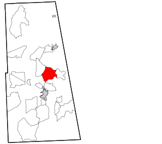
Peavine is a census-designated place (CDP) in Adair County, Oklahoma, United States. The population was 423 at the 2010 census.

Rocky Mountain is a census-designated place (CDP) in Adair County, Oklahoma, United States. The population was 420 at the 2010 census.

West Peavine is a census-designated place (CDP) in Adair County, Oklahoma, United States. The population was 218 at the 2010 census.
Rocky Ford is a census-designated place (CDP) in Delaware and Cherokee counties, Oklahoma, United States. The population was 61 at the 2010 census.

Wickliffe is a census-designated place (CDP) in Mayes County, Oklahoma, United States. The population was 99 at the 2000 census, which declined to 75 in 2010, a drop of 25 percent.

Bushyhead is a census-designated place (CDP) in Rogers County, Oklahoma, United States. The population was 1,314 at the 2010 census, a 9.2 percent increase over the figure of 1,203 recorded in 2000. Established on the St. Louis-San Francisco Railway between Claremore and Vinita, the community was named for Dennis W. Bushyhead, Principal Chief of the Cherokee, 1879–1887. The post office existed from April 18, 1898, until November 15, 1955.
Justice is a census-designated place (CDP) in Rogers County, Oklahoma, United States. The population was 1,311 at the 2000 census.
Limestone is a census-designated place (CDP) in Rogers County, Oklahoma, United States, at an elevation of 705 feet. It is located less than 10 miles west of Claremore, Oklahoma on Oklahoma State Highway 20. The population was 753 as of July 2020.

Sequoyah is a census-designated place (CDP) in Rogers County, Oklahoma, United States. The population was 671 at the 2000 census.
Belfonte is a census-designated place (CDP) in Sequoyah County, Oklahoma, United States. It is part of the Fort Smith, Arkansas-Oklahoma Metropolitan Statistical Area. The population was 426 at the 2000 census.
Brent is a census-designated place (CDP) in Sequoyah County, Oklahoma, United States, south of Sallisaw. It is part of the Fort Smith, Arkansas-Oklahoma Metropolitan Statistical Area. The population was 504 at the 2000 census.
Evening Shade is a census-designated place (CDP) in Sequoyah County, Oklahoma, United States. It is part of the Fort Smith, Arkansas-Oklahoma Metropolitan Statistical Area. The population was 359 at the 2010 census.
Marble City Community is a census-designated place (CDP) in Sequoyah County, Oklahoma, United States. It is part of the Fort Smith, Arkansas-Oklahoma Metropolitan Statistical Area. The population was 420 at the 2000 census.

McKey is a census-designated place (CDP) in Sequoyah County, Oklahoma, United States. It is part of the Fort Smith, Arkansas-Oklahoma Metropolitan Statistical Area. The population was 135 at the 2000 census. McKey was established on the Old Osage and Arkansas Valley Railroad near MacKey's Salt Works. The post office existed from March 13, 1891, until July 14, 1928.
Short is a census-designated place (CDP) in Sequoyah County, Oklahoma, United States. It is part of the Fort Smith, Arkansas-Oklahoma Metropolitan Statistical Area. The population was 328 at the 2000 census.
Stony Point is a census-designated place (CDP) in Sequoyah County, Oklahoma, United States. It is part of the Fort Smith, Arkansas-Oklahoma Metropolitan Statistical Area. The population was 177 at the 2000 census.

Troxelville is a census-designated place (CDP) in Snyder County, Pennsylvania, United States. The population was 192 at the 2000 census.

Grantley is a census-designated place (CDP) in York County, Pennsylvania, United States. The population was 3,628 at the 2010 census.

