Salem, Oklahoma

Last updated

Salem, Oklahoma
Adair County Oklahoma incorporated and unincorporated areas Salem highlighted.svg
Location within Adair County and the state of Oklahoma
Coordinates: 35°45′40″N94°34′22″W / 35.76111°N 94.57278°W / 35.76111; -94.57278 [1]
Country United States
State Oklahoma
County Adair
Area
  Total3.3 sq mi (8.6 km2)
  Land3.3 sq mi (8.6 km2)
  Water0.0 sq mi (0.0 km2)
Elevation
[1]
1,096 ft (334 m)
Population
 (2010)
  Total112
  Density34/sq mi (13.0/km2)
Time zone UTC-6 (Central (CST))
  Summer (DST) UTC-5 (CDT)
FIPS code 40-64875 [2]
GNIS feature ID2409236 [1]

Salem is a census-designated place (CDP) in Adair County, Oklahoma, United States. The population was 112 at the 2010 census. [3]

Contents

Geography

According to the United States Census Bureau, the CDP has a total area of 3.3 square miles (8.5 km2), all land.

Demographics

As of the census [2] of 2000, there were 89 people, 40 households, and 26 families residing in the CDP. The population density was 26.8 inhabitants per square mile (10.3/km2). There were 46 housing units at an average density of 13.9/sq mi (5.3/km2). The racial makeup of the CDP was 49.44% White, 42.70% Native American, and 7.87% from two or more races. Hispanic or Latino of any race were 1.12% of the population.

There were 40 households, out of which 30.0% had children under the age of 18 living with them, 52.5% were married couples living together, 7.5% had a female householder with no husband present, and 35.0% were non-families. 32.5% of all households were made up of individuals, and 10.0% had someone living alone who was 65 years of age or older. The average household size was 2.23 and the average family size was 2.81.

In the CDP, the population was spread out, with 21.3% under the age of 18, 9.0% from 18 to 24, 27.0% from 25 to 44, 29.2% from 45 to 64, and 13.5% who were 65 years of age or older. The median age was 40 years. For every 100 females, there were 78.0 males. For every 100 females age 18 and over, there were 84.2 males.

The median income for a household in the CDP was $21,875, and the median income for a family was $20,625. Males had a median income of $10,000 versus $16,250 for females. The per capita income for the CDP was $7,281. There were 35.3% of families and 34.3% of the population living below the poverty line, including 38.5% of under eighteens and 28.6% of those over 64.

Related Research Articles

<span class="mw-page-title-main">Olivet, New Jersey</span> Populated place in Salem County, New Jersey, US

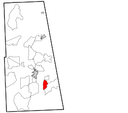
Olivet is an unincorporated community and census-designated place (CDP) located within Pittsgrove Township, in Salem County, in the U.S. state of New Jersey. As of the 2010 United States Census, the CDP's population was 1,408.

<span class="mw-page-title-main">Salem, New Mexico</span> CDP in New Mexico, United States

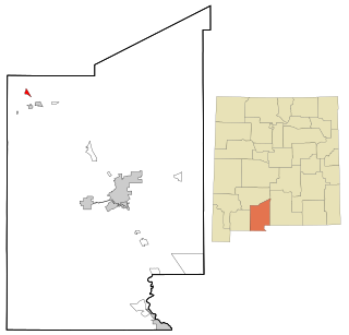
Salem is a census-designated place (CDP) in Doña Ana County, New Mexico, United States. The population was 942 at the 2010 census. It is part of the Las Cruces Metropolitan Statistical Area.

<span class="mw-page-title-main">Lyons Switch, Oklahoma</span> Census-designated place in Oklahoma, United States

Lyons Switch is a census-designated place (CDP) in Adair County, Oklahoma, United States. The population was 288 at the 2010 census.

Watts Community is a former census-designated place (CDP) in Adair County, Oklahoma, United States. The population was 500 at the 2000 census.

<span class="mw-page-title-main">West Peavine, Oklahoma</span> Census-designated place in Oklahoma, United States

West Peavine is a census-designated place (CDP) in Adair County, Oklahoma, United States. The population was 218 at the 2010 census.

<span class="mw-page-title-main">Briggs, Oklahoma</span> Census-designated place in Oklahoma, United States

Briggs is an unincorporated community and census-designated place (CDP) in Cherokee County, Oklahoma, United States. The population was 303 at the 2010 census.

<span class="mw-page-title-main">Dry Creek, Oklahoma</span> Census-designated place in Oklahoma, United States

Dry Creek is an unincorporated community and census-designated place (CDP) in Cherokee County, Oklahoma, United States. The population was 227 at the 2010 census.

Cayuga Springs is an unincorporated community and census-designated place (CDP) in Delaware County, Oklahoma, United States. The population was 140 at the 2010 census, a 33.3 percent increase over the figure of 105 recorded in 2000.

<span class="mw-page-title-main">Dennis, Oklahoma</span> Census-designated place in Oklahoma, United States

Dennis is an unincorporated community and census-designated place (CDP) in Delaware County, Oklahoma, near Grand Lake. The population was 195 at the 2010 census. The Dennis Post Office existed from March 25, 1914, until January 31, 1956. It is said to be named for a local resident, Peter Dennis.

Rocky Ford is a census-designated place (CDP) in Delaware and Cherokee counties, Oklahoma, United States. The population was 61 at the 2010 census.

Iron Post is a census-designated place (CDP) in Mayes County, Oklahoma, United States. The population was 117 at the 2000 census, but had declined to 92 in 2010, a loss of more than 21 percent.

<span class="mw-page-title-main">Mazie, Oklahoma</span> CDP in Oklahoma, United States

Mazie is a census-designated place (CDP) in Mayes County, Oklahoma, United States. The population was 91 at the 2010 census.

Pump Back is a census-designated place (CDP) in Mayes County, Oklahoma, United States. The population was 175 at the 2010 census compared to 155 at the 2000 census, a gain of 13 percent.

Sams Corner is a census-designated place (CDP) in Mayes County, Oklahoma, United States. The population was 137 at the 2010 census, compared to 126 at the 2000 census.

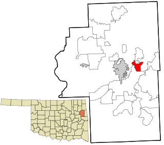
Justice is a census-designated place (CDP) in Rogers County, Oklahoma, United States. The population was 1,311 at the 2000 census.

<span class="mw-page-title-main">Akins, Oklahoma</span> CDP in Oklahoma, United States

Akins is a census-designated place (CDP) in Sequoyah County, Oklahoma, United States. It is part of the Fort Smith, Arkansas-Oklahoma Metropolitan Statistical Area. The population was 493 at the 2010 census, an increase of 9.8 percent over the figure of 449 recorded in 2000.

Belfonte is a census-designated place (CDP) in Sequoyah County, Oklahoma, United States. It is part of the Fort Smith, Arkansas-Oklahoma Metropolitan Statistical Area. The population was 426 at the 2000 census.

Brent is a census-designated place (CDP) in Sequoyah County, Oklahoma, United States, south of Sallisaw. It is part of the Fort Smith, Arkansas-Oklahoma Metropolitan Statistical Area. The population was 504 at the 2000 census.

Flute Springs is a census-designated place (CDP) in Sequoyah County, Oklahoma, United States. It is part of the Fort Smith, Arkansas-Oklahoma Metropolitan Statistical Area. The population was 182 at the 2000 census.

<span class="mw-page-title-main">New Salem-Buffington, Pennsylvania</span> Former CDP in Pennsylvania, United States

New Salem-Buffington was a census-designated place (CDP) in Fayette County, Pennsylvania, United States and part of the Pittsburgh Metro Area. The population was 808 at the 2000 census. For the 2010 census the area was split into two CDPs, New Salem and Buffington. Both communities are located in Menallen Township.

References

  1. 1 2 3 U.S. Geological Survey Geographic Names Information System: Salem, Oklahoma
  2. 1 2 "U.S. Census website". United States Census Bureau . Retrieved January 31, 2008.
  3. "Geographic Identifiers: 2010 Demographic Profile Data (G001): Salem CDP, Oklahoma". U.S. Census Bureau, American Factfinder. Archived from the original on February 12, 2020. Retrieved July 15, 2013.