
Port Wakefield is a town at the mouth of the River Wakefield, at the head of the Gulf St Vincent in South Australia. It was the first government town to be established north of the state capital, Adelaide. Port Wakefield is situated 98.7 kilometres from the Adelaide city centre on the Port Wakefield Highway section of the A1 National Highway.
Kudla is a locality in the northern Adelaide suburbs, 34 km from the city centre, just south of Gawler. It is in the Town of Gawler local government area.

Buccleuch is a place in South Australia situated along the Pinnaroo railway line and Mallee Highway (B12), approximately 140 km east of Adelaide. It is part of the Coorong District Council. There is an active Lutheran Church in Buccleuch.

Wilmington is a town and locality in the Yorke and Mid North region of South Australia.The town is located in the District Council of Mount Remarkable local government area, 305 kilometres (190 mi) north of the state capital, Adelaide.

Callington is a small town on the eastern slopes of the Adelaide Hills, in South Australia. Callington is situated on the Bremer River, and is adjacent to the South Eastern Freeway and the Adelaide-Wolseley railway line, however no trains have stopped at the station for many years. Callington is located within the state electoral district of Kavel and the federal division of Mayo.

Bumbunga is a locality in the Mid North of South Australia 125 kilometres (78 mi) north of Adelaide. It lies 5 kilometres (3.1 mi) east of Lake Bumbunga.
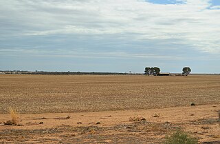
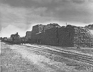
Peebinga is a town and locality in the Australian state of South Australia. Peebinga was the terminus of the Peebinga railway line which was built in 1914 as part of a major state government project to open up the Murray Mallee for grazing and cropping.

Coonamia is a lightly populated rural locality in the Mid North region of South Australia, on the plains between Port Pirie and the Southern Flinders Ranges. About 3 km (2 mi) south-east of the centre of Port Pirie, its area is 3.65 square km.
Solomontown is a suburb of Port Pirie in South Australia. It was historically a separate town. It was named after Emanuel Solomon, who owned the land that the town developed on.

Light Pass is a settlement in the Barossa Valley region of South Australia. It was named by Charles Flaxman in honour of William Light. Light Pass is the site of two Lutheran churches and a public primary school.
Edillilie is a small town on Eyre Peninsula in South Australia. It is on the Tod Highway and Eyre Peninsula Railway north of Port Lincoln.
Elwomple is a locality in The Coorong District Council in the South Australian Murray Mallee, southeast of Tailem Bend. The northwest corner is the junction of the Mallee Highway which forms the northern boundary of Elwomple, and the Dukes Highway which forms the southwestern boundary. The Bend Motorsport Park was developed in Elwomple adjacent to this junction. In September 2017, before the facility opened, the boundary between Tailem Bend and Elwomple was adjusted so that The Bend Motorsport Park was officially in Tailem Bend, not Elwomple.

Ucolta is a locality in the Mid North region of South Australia. It was named for a former railway station on the South Australian Railways' 1067 mm narrow-gauge railway line between Port Pirie and the New South Wales border. After the line was re-engineered and converted to 1435 mm standard gauge in 1970, when the infrastructure was demolished, trains did not stop there.
Stockyard Creek is a locality between Hamley Bridge and Owen, South Australia in the Mid North region of South Australia. It was established on the Hamley Bridge to Balaklava railway at the site of stockyards used by CB Fisher, 51+3⁄4 miles (83.3 km) north of Adelaide railway station.
Kybunga is a locality in the Mid North of South Australia. It was on the Gladstone railway line 87+1⁄2 miles (140.8 km) north of Adelaide on the plains to the west of the Clare Valley. Kybunga school opened in 1881 and closed in 1988. The former Methodist and Uniting church opened in 1886 and is now a private residence. Kybunga was once a stop on the Hamley Bridge-Gladstone railway line from 1876 until 1989.
Ulooloo is a locality in the Mid North of South Australia. It is midway between Burra and Peterborough on the Barrier Highway from Adelaide to Broken Hill, New South Wales.
Hammond is a town and locality in the Australian state of South Australia located in the southern Flinders Ranges.

Oodla Wirra is a small town in the upper Mid North of South Australia. It is on the Barrier Highway approximately halfway from Adelaide to Broken Hill.
Germein Bay is a locality in the Australian state of South Australia about 205 kilometres north of the state capital of Adelaide and about 6 kilometres (3.7 mi) northeast of the city of Port Pirie.
