This article relies largely or entirely on a single source .(May 2021) |

Burwick Holm
Burwick Holm (Shetland)

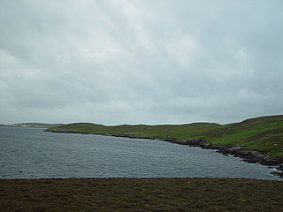
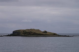
Burwick Holm is a small island off the west coast of Mainland, Shetland. It is located in the Bur Wick inlet, and near Scalloway. [1]
This article relies largely or entirely on a single source .(May 2021) |
Burwick Holm is a small island off the west coast of Mainland, Shetland. It is located in the Bur Wick inlet, and near Scalloway. [1]

Bressay is a populated island in the Shetland archipelago of Scotland.

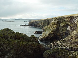
Hildasay, also known as Hildisay, is an uninhabited island off the west coast of the Shetland Mainland.
This is a list of the extreme points of the United Kingdom: the points that are farther north, south, east or west than any other location. Traditionally the extent of the island of Great Britain has stretched "from Land's End to John o' Groats".

Esha Ness, also spelled Eshaness, is a peninsula on the west coast of Northmavine, on the island of Mainland, Shetland, Scotland. Esha Ness Lighthouse is located on the west coast of the peninsula, just south of Calder's Geo. The lighthouse was designed by David Alan Stevenson and commissioned in 1929. The hamlet of Tangwick contains the Tangwick Haa, a former Laird's house that has been a museum since 1987.
West Linga is an uninhabited island located between Mainland and Whalsay in Shetland, Scotland.
Burrastow is a location on the west shore of Vaila Sound near the village of Walls on the Shetland Mainland, Scotland. There are two small piers and the imposing 18th-century Burrastow House. To the east is the bay of Lera Voe and the two small islets of Holm of Breibister and Holm of Burrastow. To the south is Wester Sound, which lies between the mainland and Vaila. The rocky coast contains numerous caves, geos and skerries. Otters and seals are commonly seen offshore.
Burwick is a small peninsula north of Scalloway in the Shetland Islands, Scotland. The Hill of Burwick rises to 107 metres (351 ft), the Ness of Burwick is a headland that guards the bay of Bur Wick, and Burwick Holm is a small island with an elevation of about 10 metres (33 ft), just off shore in the Scalloway Islands.
Brough Holm is a small island off Unst, in the North Isles of Shetland. It is off Westing, which as the name implies is on the west coast of Unst.
Lady's Holm is an island off southern Mainland in the Shetland Islands. It is not to be confused with the Maiden Stack, which is also known as "Frau Stack"
Law Ting Holm is a small promontory at the north end of the freshwater Loch of Tingwall, Mainland Shetland, Scotland. It was once an islet entirely surrounded by water, joined to the shore by a stone causeway 1.7 metres (6 ft) wide and 42.7 metres (140 ft) long. In the 1850s the levels of the loch were lowered and the holm evolved to its present form. The Loch of Tingwall is west of the town of Lerwick and has one additional island - Holm of Setter.

Holm of Grimbister is an inhabited tidal islet in the Orkney archipelago of Scotland. Located in the Bay of Firth near Finstown it is connected to Mainland Orkney by a causeway.

Isbister Holm is a small islet in the Shetland islands of Scotland, situated roughly 2 kilometres (1.2 mi) east off the coast of Isbister, Whalsay. The highest point of the islet is about 65 feet (20 m) and it measures roughly 500 metres (1,600 ft) by 250 metres (820 ft). To the north are the islets of Mooa and Nista. On 12 November 1778 Jufron Ingester was shipwrecked, probably on the holm, the precise location not being certain. It was carrying some 260 tons of skins, tallow and coarse hose from Ireland to Copenhagen. One crew member died and the cargo was not salvaged.

Mooa is a small islet of the Shetland Islands of Scotland, situated roughly 2 kilometres (1.2 mi) east off the coast of Whalsay. It lies to the north of Isbister Holm and south of Nista. The highest point of the islet is 63 feet (19 m).
The Inner Holm of Skaw is a small, uninhabited islet off the northern tip of the island of Whalsay, in the Shetland Islands of Scotland, north of the village of Skaw.
The Outer Holm of Skaw is a small, uninhabited islet, a rock outlier off the northeast coast of the island of Whalsay, in the Shetland Islands of Scotland.
The Holm of Skaw is a small islet off the northeast coast of the island of Unst. It is just northeast of the settlement of Skaw. The island is 57 feet (17 m) in height. There is a lighthouse on the island. Tidal currents are slack between Holm of Skaw and Herma Ness at high water, and the passage may be made by small boats. The Skaw Röst, a dangerous tidal race, forms off the shore of the Holm of Skaw and Lamba Ness.

The Skate of Marrister is a flat ledge that extends about 300 yards (270 m) from the western shore of Whalsay, in the Shetland islands of Scotland. It is slightly more than 1 mile (1.6 km) north-north-west from Symbister Ness off the village of Marrister, in Linga Sound. At low tide the ledge rises 5 feet (1.5 m) above the water. There is a risk that the strong tide in Whalsay Sound will carry a boat onto the Skate. There is a minor light on the Skate with a nominal range of four miles, flashing green every six seconds.
Rumble is a skerry in the Shetland islands of Scotland, situated roughly 4 kilometres (2.5 mi) east off the coast of Huxter, southeastern Whalsay. It lies 0.75 miles (1.21 km) to southwest of East Linga. The main island, also known as Rumble Holm, is 27 feet (8.2 m) high. Nearby and to the north are the Flaeshans of Rumble, a series of small islets and stacks and Burlastack of Rumble lies to the east. On the northern side of the main island is an inlet, known as the Voe of Rumble. Lobsters and prawns are said to shelter here. It is also mentioned that a ship named Griften of unknown nationality was shipwrecked either here or on the Holm of Sandwick in 1611.
The Holm of Sandwick is an islet, located roughly 100 metres (330 ft) off Haa Ness and the southwestern side of Whalsay, in the Shetland Islands of Scotland. The small groups of islets to the west are called the Flaeshans of Sandwick. To the southwest is Sava Skerry. It is reported that a ship named Griften of unknown nationality was shipwrecked either here or on Rumble Holm in 1611.
60°09′N1°18′W / 60.150°N 1.300°W
| | This Shetland location article is a stub. You can help Wikipedia by expanding it. |