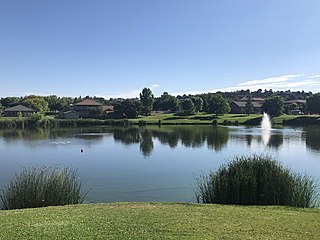
Payson is a town in northern Gila County, Arizona, United States. Due to Payson's location being very near to the geographic center of Arizona, it has been called "The Heart of Arizona". The town is surrounded by the Tonto National Forest, the largest of the six national forests in Arizona and the ninth largest national forest in the United States.[1][2]

U.S. Route 93 (US 93) is a major north–south 1,359-mile (2,187 km) U.S. Numbered Highway in the western United States, that connects U.S. Route 60 (US 60) in Wickenburg, Arizona, with British Columbia Highway 93 at the Canadian border. The highway passes through Kingman, Arizona; Las Vegas, Nevada; Twin Falls, Idaho; and Missoula, Montana.

The Salt River is a river in Gila and Maricopa counties in Arizona, United States, that is the largest tributary of the Gila River. The river is about 200 miles (320 km) long. Its drainage basin covers about 13,700 square miles (35,000 km2). The longest of the Salt River's many tributaries is the 195-mile (314 km) Verde River. The Salt's headwaters tributaries, the Black River and East Fork, increase the river's total length to about 300 miles (480 km). The name Salt River comes from the river's course over large salt deposits shortly after the merging of the White and Black Rivers.

The Tonto National Forest, encompassing 2,873,200 acres, is the largest of the six national forests in Arizona and is the ninth largest national forest in the United States. The forest has diverse scenery, with elevations ranging from 1,400 feet in the Sonoran Desert to 7,400 feet in the ponderosa pine forests of the Mogollon Rim. The Tonto National Forest is also one of the most visited "urban" forests in the United States.

U.S. Route 89 is a north–south United States Numbered Highway with two sections, and one former section. The southern section runs for 848 miles (1,365 km) from Flagstaff, Arizona, to the southern entrance of Yellowstone National Park. The northern section runs for 404 miles (650 km) from the northern entrance of Yellowstone National Park in Montana, ending at the Canadian border. Unnumbered roads through Yellowstone connect the two sections. Before 1992, US 89 was a Canada–Mexico, border-to-border highway that ended at Nogales, Arizona, on its southern end.

State Route 87 is a 272.66-mile (438.80 km) north–south highway that travels from I-10 near Picacho northward to State Route 264 near Second Mesa.

The Apache Trail in Arizona was a stagecoach trail that ran through the Superstition Mountains. It was named the Apache Trail after the Apache Indians who originally used this trail to move through the Superstition Mountains.
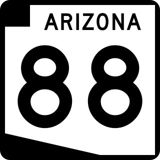
State Route 88 is a long state highway in the U.S. state of Arizona. It runs from U.S. Route 60 in Apache Junction through desert terrain to SR 188 near Roosevelt Dam. Following the Salt River for much of its length, the section east of Tortilla Flat is known as the Apache Trail and is part of the National Forest Scenic Byway system. The Apache Trail was built in the mid-1920s, and the number 88 was assigned in 1927. An eastern extension of State Route 88 to Globe, Arizona was redesignated as State Route 188 on August 20, 1999.

State Route 260, also known as SR 260, is a 217.78-mile (350.48 km) long east–west major state highway in the north-central part of the U.S. state of Arizona. It connects State Route 89A in Cottonwood to U.S. Route 180 and U.S. Route 191 in Eagar. The highway begins in Yavapai County before entering Coconino County and then entering Gila County before reentering Coconino County and then entering Navajo and Apache counties, where the highway ends.

Pennsylvania Route 59 is a 39-mile (63 km) long state highway located in northwest Pennsylvania. The route links Warren to Smethport, terminating at U.S. Route 6 at both ends. PA 59 acts as a northerly bypass to US 6, directly connecting Warren and Smethport while US 6 dips south to serve Kane and Mount Jewett.
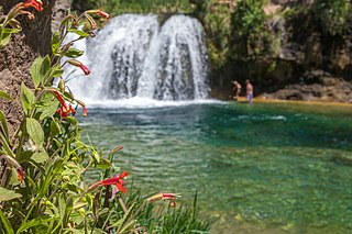
Fossil Creek is a perennial stream accessed by forest roads near the community of Camp Verde in the U.S. state of Arizona. Primary access is from Forest Road 708 off Arizona State Route 260 east of Camp Verde. A tributary of the Verde River, Fossil Creek flows from its headwaters on the Mogollon Rim to meet the larger stream near the former Childs Power Plant.

The East Verde River is a tributary of the Verde River in the U.S. state of Arizona. Beginning on the Mogollon Rim near Washington Park, it flows generally southwest through Gila County and the Tonto National Forest northeast of Phoenix. Near the middle of its course, it passes to within about 5 miles (8 km) of Payson, which is southeast of the river. The East Verde River flows through parts of the Mazatzal Wilderness west of Payson.

Tonto Creek is a 72.5-mile-long (116.7 km) stream located in the Mogollon Rim area of the state of Arizona on the north edge of the Tonto National Forest. The closest town, Payson, is 18 miles (29 km) away. Tonto Creek is a stream that flows year round, starting just below the Mogollon Rim, at the northern edge of Tonto National Forest. The creek continues its descent through the Hellsgate Wilderness area and eventually into a wide valley in the Sonoran Desert. It continues through the desert and into the Salt River within the north end of Theodore Roosevelt Lake. The facilities are maintained by Tonto National Forest division of the USDA Forest Service.

Mount McDowell, more commonly referred to as Red Mountain, is located on the Salt River Pima-Maricopa Indian Reservation, just north of Mesa, Arizona. It is named after General Irvin McDowell, a Union officer in the Civil War. Its elevation is 2,832 feet (863 m). It is not the same landmark as the McDowell Peak, which is 11 miles (18 km) away to the northwest.
Many arterial roads in the Phoenix metropolitan area have the same name in multiple cities or towns. Some roads change names or route numbers across town borders, resulting in occasional confusion. For example, the road known as Apache Boulevard in Tempe continues east as Main Street in neighboring Mesa and then as Apache Trail in Apache Junction. Although Broadway Road maintains the same name through Goodyear, Avondale, Phoenix, Tempe, Mesa, and Apache Junction, each town uses a different reference point for address numbers.

Sunflower is a region of Maricopa County, Arizona, United States adjacent to the Mazatzal Wilderness, west of Tonto National Forest and northwest of Roosevelt Reservoir. Formerly a mercury-mining district, Sunflower is now a destination for hikers, campers and off-road vehicle tours. Sunflower is located near Arizona State Route 87, 22.8 miles (36.7 km) northeast of Fountain Hills. Route 87 near Sunflower is called the Beeline Highway.
Roosevelt is a census-designated place (CDP) in Gila County, Arizona, United States. The population was 28 at the 2010 census.
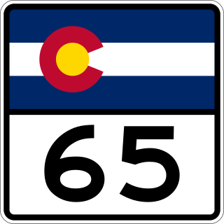
State Highway 65 (SH 65) is a state highway in Colorado that crosses the Grand Mesa. The highway along with a road to Lands End Overlook were designated as the Grand Mesa National Scenic Byway in 1996. SH 65's southern terminus is at SH 92 east of Delta, and its northern terminus is at Interstate 70 (I-70) and U.S. Route 6 (US 6) northeast of Palisade.

State Highway 47 (SH‑47) is a 12.420-mile (19.988 km) state highway in Fremont County, Idaho, United States, that connects U.S. Route 20 (US 20) in Ashton with the Mesa Falls Scenic Byway.
Mesa del Caballo is a census-designated place (CDP) in Gila County, Arizona, United States. The population was 765 at the 2010 census.
