Buttes of the Cross

Last updated
Buttes of the Cross
Buttes of the Cross.jpg
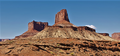
Buttes of the Cross, east aspect
Highest point
Elevation 5,642 ft (1,720 m) [1]
Prominence 1,042 ft (318 m) [1]
Parent peak Point 5820 [2]
Isolation 1.59 mi (2.56 km) [1]
Coordinates 38°21′45″N110°03′13″W / 38.3625870°N 110.0536227°W / 38.3625870; -110.0536227 [3]
Geography
USA Utah relief location map.svg
Red triangle with thick white border.svg
Buttes of the Cross
Location in Utah
Usa edcp relief location map.png
Red triangle with thick white border.svg
Buttes of the Cross
Buttes of the Cross (the United States)
Location Glen Canyon National Recreation Area
Wayne County, Utah, US
Parent range Colorado Plateau
Topo map USGS Cleopatras Chair
Geology
Age of rock Late Triassic
Type of rock Wingate Sandstone
Climbing
Easiest route class 5.x climbing [2]

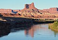
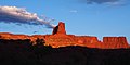
Buttes of the Cross is two sandstone summits located in the northern reach of Glen Canyon National Recreation Area, in Wayne County of Utah, United States. [3] The larger and higher south butte reaches an elevation of 5,642 feet (1,720 meters), whereas the north butte rises to 5,569 feet, with approximately 0.6 miles (0.97 km) separation between them. [2] When viewed from the north-northeast near Labyrinth Canyon, they align to form the shape of a cross, creating the appearance of a single butte. The name "Butte of the Cross" was first applied by John Wesley Powell during the Powell Geographic Expedition of 1869. [3] A few miles further down the Green River, Powell finds that this geographical feature is two buttes when viewed from the east, so it was renamed Buttes of the Cross. [4] Buttes of the Cross towers over 1,400 feet (430 meters) above its surrounding terrain. It is situated 6.8 miles west of Candlestick Tower, and one-half mile outside the boundary of Canyonlands National Park.

Contents

Geology

Buttes of the Cross is composed of hard, fine-grained Wingate Sandstone, which is the remains of wind-borne sand dunes deposited approximately 200 million years ago in the Late Triassic. This Wingate sandstone, capped by Kayenta Formation, forms steep cliffs as it overlays softer layers of the Chinle Formation, which is exposed down to a prominent ledge formed by the Moss Back Member. Slopes below this ledge are Moenkopi Formation, down to the White Rim. [4] Precipitation runoff drains into the nearby Green River, which in turn is part of the Colorado River drainage basin.

Climbing

The first ascent of the North Butte was made May 25, 1987, by Paul Horton and Lynn Watson via West Chimneys. [5] The South Butte was climbed in 1994 by John Rosholt and Keen Butterworth via The Epicurean route, class 5.10c, on the north face. [6]

Climate

Spring and fall are the most favorable seasons to visit Buttes of the Cross. According to the Köppen climate classification system, it is located in a Cold semi-arid climate zone, which is defined by the coldest month having an average mean temperature below 32 °F (0 °C), and at least 50% of the total annual precipitation being received during the spring and summer. This desert climate receives less than 10 inches (250 millimeters) of annual rainfall, and snowfall is generally light during the winter.

See also

Related Research Articles

<span class="mw-page-title-main">Canyonlands National Park</span> National park in Utah, United States

Canyonlands National Park is an American national park located in southeastern Utah near the town of Moab. The park preserves a colorful landscape eroded into numerous canyons, mesas, and buttes by the Colorado River, the Green River, and their respective tributaries. Legislation creating the park was signed into law by President Lyndon B. Johnson on September 12, 1964.

<span class="mw-page-title-main">Geology of the Capitol Reef area</span>

The exposed geology of the Capitol Reef area presents a record of mostly Mesozoic-aged sedimentation in an area of North America in and around Capitol Reef National Park, on the Colorado Plateau in southeastern Utah.

<span class="mw-page-title-main">Angel Arch</span>

Angel Arch is the largest natural arch located within Canyonlands National Park, in San Juan County, Utah. Some consider it the most beautiful and spectacular arch in the park, if not the entire canyon country. It is situated in a side canyon of Salt Creek Canyon, in the Needles District of the park. Precipitation runoff from Angel Arch drains north into the nearby Colorado River via Salt Creek. A 29-mile round-trip hike to Angel Arch leads to a viewpoint, and an additional 0.75-mile trail scrambles up into the arch opening. The arch's descriptive name comes from its resemblance to an angel with wings folded, and standing with its back to the arch opening. Before this feature's name was officially adopted in 1963 by the U.S. Board on Geographic Names, it was called Pegasus Arch. The first ascent was made in June 1993, by John Markel and Kevin Chase.

<span class="mw-page-title-main">Monster Tower</span>

Monster Tower is a 600-foot (180-meter) tall sandstone tower located in the Island in the Sky District of Canyonlands National Park, in San Juan County, Utah, United States.

<span class="mw-page-title-main">Candlestick Tower</span> Rock formation in Utah, United States

Candlestick Tower is a 450-foot-tall (140 m) sandstone butte located in the Island in the Sky District of Canyonlands National Park, in San Juan County, Utah. Its descriptive name comes from its resemblance to a candlestick. Candlestick Tower is composed of Wingate Sandstone, which is the remains of wind-borne sand dunes deposited approximately 200 million years ago in the Late Triassic.

<span class="mw-page-title-main">Washer Woman</span> Sandstone arch and tower in Utah, US

Washer Woman is a 500-foot (150-meter) tall sandstone arch and tower located in the Island in the Sky District of Canyonlands National Park, in San Juan County, Utah. It is situated 300 feet northwest of the slightly higher Monster Tower. Washer Woman is so named because the feature gives the appearance of a washerwoman bent over a washtub. This geographical feature's name was officially adopted in 1986 by the U.S. Board on Geographic Names after previously having similar names such as Washer-Woman Arch and The Washer Woman. Washer Woman and Monster Tower are an eroded fin composed of Wingate Sandstone, which is the remains of wind-borne sand dunes deposited approximately 200 million years ago in the Late Triassic. Airport Tower is set 1.6 mi (2.6 km) to the east, and Mesa Arch is situated 1.5 mi (2.4 km) to the west. A short hike to Mesa Arch provides the easiest view of Washer Woman. Access to this formation is via the four-wheel drive White Rim Road, which is the other option to see it. The top of this geological formation rises 1,300 feet above the road in approximately one mile. Precipitation runoff from Washer Woman drains southeast into the nearby Colorado River via Buck Canyon.

<span class="mw-page-title-main">Owl Rock</span> Landform in Navajo County, Arizona

Owl Rock is a 6,547-foot elevation sandstone summit located south of Monument Valley, in northeast Arizona. It is situated 7 miles (11 km) north of Kayenta on Navajo Nation land, and can be seen from Highway 163 perched on the east edge of Tyende Mesa, where it towers 1,000 feet above the surrounding terrain. Its nearest higher neighbor is Agathla Peak, 1.4 miles (2.3 km) to the east-northeast, on the opposite side of this highway. Precipitation runoff from this feature drains into El Capitan Wash, which is part of the San Juan River drainage basin. The first ascent of Owl Rock was made in April 1966 by Fred Beckey and Harvey Carter by climbing cracks on the west face, and then bolting up a smooth south nose to the summit. They employed 20 pitons and 14 bolts on this route called Warpath. The descriptive name stems from its uncanny resemblance to an owl when viewed from the east. This feature is known as Bee 'Adizí in Navajo language meaning "spindle", and this sacred place is considered to be a spindle left behind by the Holy People. A newer name for it is Tsé Ts'óózí, meaning "Slim Rock".

<span class="mw-page-title-main">Airport Tower (Canyonlands)</span>

Airport Tower is a 700-foot (210-meter) tall sandstone butte located in the Island in the Sky District of Canyonlands National Park, in San Juan County, Utah. It is situated 1.64 mile east of Washer Woman, which is a towering arch similar in height. Each are composed of Wingate Sandstone, which is the remains of wind-borne sand dunes deposited approximately 200 million years ago in the Late Triassic. The nearest higher neighbor is Monster Tower, 1.6 mi (2.6 km) to the west, Tiki Tower is one-half mile northwest, and Mesa Arch is situated 3.2 mi (5.1 km) to the west. A short hike to Mesa Arch provides the easiest view of Airport Tower. Access to this tower is via the four-wheel drive White Rim Road, which is another option to see Airport Tower. The top of this geological formation rises 1,400 feet above the road in less than one mile. Precipitation runoff from Airport Tower drains southeast into the nearby Colorado River via Buck and Lathrop Canyons. This geographical feature's name was officially adopted in 1986 by the U.S. Board on Geographic Names. It was so named because the rock formation resembles the appearance of an airport control tower.

<span class="mw-page-title-main">Zeus and Moses</span> Rock formations in Utah, United States

Zeus and Moses are a pair of 500-foot-tall (150 m) sandstone formations located in the Island in the Sky District of Canyonlands National Park, in San Juan County, Utah, United States. These rock towers' names refer to Zeus, a god in Greek mythology, and Moses, an important prophet in several religious traditions. Zeus and Moses are composed of Wingate Sandstone, which is the remains of wind-borne sand dunes deposited approximately 200 million years ago in the Late Triassic. This formation is situated in Taylor Canyon, 3 mi (4.8 km) north-northeast of Upheaval Dome. Access to the towers is via the four-wheel-drive White Rim Road, and a spur road into Taylor Canyon. The top of this geological formation rises 900 feet above the canyon floor at road's end, approximately one-half mile away. Precipitation runoff from Zeus and Moses drains into the nearby Green River via Taylor Canyon.

<span class="mw-page-title-main">Tower Butte</span>

Tower Butte is a 5,287-foot elevation sandstone summit located south of Lake Powell, in northern Arizona. Tower Butte is a butte composed of Romana and Entrada Sandstones with a Morrison Formation caprock. It is situated 9 miles (14 km) northeast of the town of Page, and 7.5 miles north of LeChee Rock, on Navajo Nation land, towering over 1,000 feet above the surrounding terrain as an iconic landmark of the area. Precipitation runoff from this feature drains into Lake Powell, which is part of the Colorado River drainage basin. The first ascent of Tower Butte was made October 23, 1994, by Jason Keith and David Insley. However, they were not the first to visit the summit as they reported finding litter from prior helicopter landings. An outfit operating out of Page flies helicopter sightseeing flights which land on the flat top of the butte where tourists have panoramic views of the Glen Canyon National Recreation Area, Lake Powell, and Navajo Mountain.

<span class="mw-page-title-main">Aztec Butte</span> Rock formation in Utah, United States

Aztec Butte is a sandstone summit, elevation 6,312 feet, located in the Island in the Sky District of Canyonlands National Park, in San Juan County, Utah. Aztec Butte is composed of white cross-bedded Navajo Sandstone, which is the remains of wind-borne sand dunes deposited approximately 170 million years ago during the Jurassic Period. It resembles the Pyramid of the Sun in Mexico, which was built by the Aztecs.

<span class="mw-page-title-main">Junction Butte</span>

Junction Butte is a 6,400-foot-elevation (2,000-meter) summit located in the Island in the Sky District of Canyonlands National Park, in San Juan County, Utah. It is set about one mile south of the southern tip of Island in the Sky. A short hike to Grand View Point provides a view of Junction Butte. Access to this butte is via the four-wheel drive White Rim Road, which is another option to view Junction Butte. Topographic relief is significant as the top of this geological formation rises 1,400 feet above the road in less than one mile. Precipitation runoff from Junction Butte drains east into the nearby Colorado River, and west into nearby Green River. Junction Butte is situated north of the junction of these two major rivers.

<span class="mw-page-title-main">Ekker Butte</span> Butte in Glen Canyon National Recreation Area in Wayne Canyon, Utah, United States

Ekker Butte is a 6,260-foot (1,910-meter) elevation summit located in the northern reach of Glen Canyon National Recreation Area, in Wayne County of Utah, United States. It is situated seven miles southeast of Buttes of the Cross, six miles northeast of Elaterite Butte, and less than two miles outside the boundary of Canyonlands National Park, where it towers over 1,400 feet above the surrounding terrain. Distant views of this remote butte can be seen from the Grand View Point and Green River Overlooks at Island in the Sky of Canyonlands National Park. This geological landmark is named for the pioneering Art Ekker family which operated the nearby Robbers Roost Ranch and grazed cattle on land adjacent to the nearby Maze. Arthur Benjamin Ekker (1911–1978) took Robert Redford on a tour of nearby Robbers Roost, the hideout of outlaw Butch Cassidy and the Wild Bunch.

<span class="mw-page-title-main">Elaterite Butte</span>

Elaterite Butte is a 6,552-foot (1,997-meter) elevation summit located in The Maze District of Canyonlands National Park, in Wayne County, Utah. Elaterite Butte is situated 6 mi (9.7 km) southwest of Ekker Butte, and the Maze Overlook is situated 2.5 mi (4.0 km) to the northeast. Elaterite Butte is composed of hard, fine-grained Wingate Sandstone, which is the remains of wind-borne sand dunes deposited approximately 200 million years ago in the Late Triassic. This Wingate sandstone overlays a 432-foot thick layer of the softer Chinle Formation. The top of this geological formation rises over 1,400 feet above Elaterite Basin. The butte and basin are named for elaterite, which is a dark brown, tar-like, elastic mineral resin that seeps from parts of the nearby White Rim Sandstone. Access to the remote butte is via a four-wheel drive road in Elaterite Basin. Precipitation runoff from Elaterite Butte drains into the nearby Green River, which in turn is within the Colorado River drainage basin.

<span class="mw-page-title-main">Chip and Dale Towers</span> Sandstone towers in Canyonlands National Park, Utah, USA

Chip and Dale Towers are two 300-foot (91-meter) tall sandstone towers located in the Island in the Sky District of Canyonlands National Park, in San Juan County, Utah. Dale Tower rises to an elevation of 5,620 feet, whereas the lower Chip Tower is 5,420-feet. Airport Tower is set 2.5 mi (4.0 km) to the southwest, and Dead Horse Point State Park overlook is situated 4.5 mi (7.2 km) to the north-northeast. Chip and Dale Towers are an eroded fin composed of hard, fine-grained Wingate Sandstone, which is the remains of wind-borne sand dunes deposited approximately 200 million years ago in the Late Triassic. This Wingate Sandstone overlays a softer layer of the Chinle Formation. Access to the towers is via the four-wheel drive White Rim Road, and a scramble to reach the base. The top of the towers rise over 1,000 feet above the road in approximately one-half mile. Precipitation runoff from Chip and Dale Towers drains east to the nearby Colorado River.

<span class="mw-page-title-main">Sixshooter Peaks</span>

The Sixshooter Peaks are two iconic sandstone summits located in Bears Ears National Monument in San Juan County, Utah, United States. The larger and higher North Sixshooter Peak rises to an elevation of 6,379 feet, whereas South Sixshooter Peak rises to 6,154 feet, with approximately 1.5 miles (2.4 km) separation between the two. These buttes tower nearly 1,400 feet above the surrounding terrain, and are historic landmarks visible from State Route 211 between Newspaper Rock and the Needles District of Canyonlands National Park. They are situated 1.5 mile outside the boundary of the park, and four miles northwest of Bridger Jack Butte. Variant names for the peaks include "North Six-Shooter Peak", "South Six-shooter Peak", "Six Shooter Peaks", and "Six-shooter Peak". They are so named because of their resemblance to a pair of revolvers pointing skyward.

<span class="mw-page-title-main">Bridger Jack Butte</span> Rock formation in Utah, United States

Bridger Jack Butte is a sandstone butte located in Bears Ears National Monument, in San Juan County, Utah, United States. Set at the northern tip of Bridger Jack Mesa and above the confluence of Indian and Lavender Creeks, the summit rises to an elevation of 5,890 feet, and towers over 700 feet above the surrounding terrain and floor of Lavender Canyon to its west. This landmark is situated four miles southeast of the Sixshooter Peaks, and is visible from State Route 211 between Newspaper Rock and the Needles District of Canyonlands National Park. "Bridger Jack" was a Paiute medicine man.

<span class="mw-page-title-main">Dominguez Butte</span> Butte in San Juan County, Utah, United States

Dominguez Butte is a 4,476-foot elevation sandstone summit located south of Lake Powell, in San Juan County of southern Utah. It is situated on Navajo Nation land, 13 miles (21 km) northeast of the town of Page, and towers over 700 feet above the surrounding terrain as a landmark of the area. Dominguez Butte has a brief appearance in the 1968 film Planet of the Apes, when a spaceship crash lands in Lake Powell.

<span class="mw-page-title-main">Angels Gate</span> Landform in the Grand Canyon, Arizona

Angels Gate is a 6,761-foot (2,061 m)-elevation summit located in the Grand Canyon, in Coconino County of Arizona, United States. It is situated seven miles (11 km) due north of the Grandview Point overlook on the canyon's South Rim, three miles (4.8 km) west of Vishnu Temple, and three point five miles (5.6 km) southeast of Zoroaster Temple. Topographic relief is significant as it rises over 4,200 feet (1,300 m) above the Colorado River in three miles. Angels Gate is the place in Paiute mythology where the gods would return to Earth by descending from the shadow world above.

<span class="mw-page-title-main">Sentinel Spire</span>

Sentinel Spire is a 5,500-foot-elevation (1,676-meter) sandstone pillar located in Colorado National Monument, in Mesa County of western Colorado, United States. This 200-foot freestanding tower is situated in Wedding Canyon, one-half mile east of the monument's visitor center, and 9 miles (14 km) west of the community of Grand Junction. It is also immediately south of Window Rock, and north of another climbing destination, Pipe Organ, both of which can be seen from viewpoints along Rim Rock Drive. The first ascent of the summit was made May 3, 1960, by Layton Kor, Harvey Carter, and John Auld via the class 5.10 route, Fast Draw. This was the day before the climbers also made the first ascent of nearby Kissing Couple. The first solo ascent was made by Ron Olevsky in March 1976, and the first free ascent was made by Andy Petefish and John Christenson in 1978. Some climbers refer to Sentinel Spire as Watusi Spear.

References

  1. 1 2 3 "Buttes of the Cross South, Utah". Peakbagger.com. Retrieved 2020-10-31.
  2. 1 2 3 "Buttes of the Cross, North - 5,569' UT". listsofjohn.com. Retrieved 2020-10-31.
  3. 1 2 3 "Buttes of the Cross". Geographic Names Information System . United States Geological Survey, United States Department of the Interior . Retrieved 2020-10-31.
  4. 1 2 S.W. Lohman, The Geologic Story of Canyonlands National Park, US Government Printing Office, 1974, page 92.
  5. "First Ascent Timeline".
  6. American Alpine Journal 1995, page 161.