Lamlash is the largest village by population on the Isle of Arran, in the Firth of Clyde, Scotland. It lies 3 miles (5 km) to the south of ferry port Brodick, in a sheltered bay on the island's east coast, facing the Holy Isle. Lamlash is the seat of Arran's local government offices, and is also the location of the island's only police station, secondary school and hospital. In common with the rest of the island, the village's main industry is tourism, and the public sector is also an important employer. Although the Clyde was once the finest fishery in Europe it is now all but gone. There are strictly speaking no fish left in the Clyde for commercial capture. Lamlash has an RNLI Lifeboat station with a B class Atlantic 75 lifeboat, covering the inshore waters around the coast of Arran, and in summer, there is a regular ferry service from Lamlash harbour to Holy Isle. The village has several buildings of historical interest, including Hamilton Terrace, which consists of two rows of idyllic single storey-and-attic cottages on the Lamlash seafront, arranged in pairs.
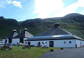
Arran distillery is a whisky distillery in Lochranza, Scotland, the only distillery on the Isle of Arran.

The County of Bute, also known as Buteshire, is a historic county and registration county of Scotland.
Cunninghame is a former comital district of Scotland and also a district of the Strathclyde Region from 1975–1996.

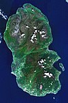
Goat Fell is the highest point on the Isle of Arran. At 874 metres (2,866 ft), it is one of four Corbetts on the island. The mountain, along with nearby Brodick Castle, is now owned by the National Trust for Scotland.

Sanda Island is a small privately owned island in Argyll and Bute, Scotland, off the southern tip of the Kintyre peninsula, near Southend and Dunaverty Castle.
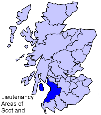
Ayrshire and Arran is a lieutenancy area of Scotland. It consists of the council areas of East Ayrshire, North Ayrshire and South Ayrshire. The area of Ayrshire and Arran is also a brand for tourist attractions.

North Ayrshire and Arran is a constituency of the British House of Commons, located in the south-west of Scotland within the North Ayrshire council area. It elects one Member of Parliament (MP) at least once every five years using the first-past-the-post voting system of voting.
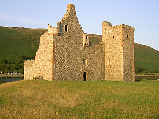
Lochranza Castle is an L-plan tower house situated on a promontory in Lochranza, on the north of the Isle of Arran in Scotland. Most of the castle was built in the 16th century.

Caisteal Abhail is a mountain on the Isle of Arran in Scotland.
The skirmish known as Cleanse the Causeway, or Clear the Causeway, took place in the High Street of Edinburgh, Scotland, on 30 April 1520, between rivals James Hamilton, 1st Earl of Arran, chief of Clan Hamilton, and Archibald Douglas, 6th Earl of Angus, chief of Clan Douglas.
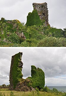
Kildonan Castle stands in the small village of Kildonan on the southern coast of the Isle of Arran in Scotland. The castle's name is derived from the name of a former resident, Saint Donan, who is said to be buried on the island.

Sgorr Ruadh is a mountain situated in the mountainous area between Strath Carron and Glen Torridon in Wester Ross in the Highland Region of Scotland. It is located in Coire Lair near Achnashellach along with two other fine mountains, Beinn Liath Mhòr and Fuar Tholl, and is often climbed in conjunction with one or both of these other mountains.

Beinn Tarsuinn is a mountain on the Isle of Arran, Scotland. It is the southernmost of the four Corbetts on the island, lying between Glen Rosa to the east and Glen Iorsa to the west.
The Sleeping Warrior is the profile of the north Arran hills in Scotland as seen from the Ayrshire coast. It is a well-known site that takes its name from a resemblance to a resting human figure. Various interpretations of the profile exist although the view of the Witches Step and Caisteal Abhail from North Ayrshire and Bute is arguably the most convincing.
Dippen is a settlement on the Isle of Arran in the Firth of Clyde, Scotland, where there is an interesting chambered cairn.
Eas Bàn is a waterfall on the island of Arran, Scotland. It lies on the Garbh Allt, a tributary of the Machrie Water.
Eas Mor is a waterfall on the island of Arran, Scotland. It is located on the Allt Mor north of Auchenhew Bridge near the village of Kildonan.

The Arran Coastal Way is a 107 kilometre long-distance trail that goes around the coastline of Arran in Scotland. As the route is circular, following the coastline of the island, it can be started and finished at any location, however in recognition of the fact that most visitors to the island arrive and depart via the Caledonian MacBrayne ferry a start/finish monument is located on the seafront near Brodick ferry terminal. The route is fully waymarked, using marker posts featuring a gannet.