
The John A. Roebling Suspension Bridge is a suspension bridge that spans the Ohio River between Cincinnati, Ohio, and Covington, Kentucky. When opened on December 1, 1866, it was the longest suspension bridge in the world at 1,057 feet (322 m) main span, which was later overtaken by John A. Roebling's most famous design of the 1883 Brooklyn Bridge at 1,595.5 feet (486.3 m). Pedestrians use the bridge to get between the hotels, bars, restaurants, and parking lots in Northern Kentucky. The bar and restaurant district at the foot of the bridge on the Kentucky side is known as Roebling Point.
Chessie System, Inc. was a holding company that owned the Chesapeake and Ohio Railway (C&O), the Baltimore and Ohio Railroad (B&O), the Western Maryland Railway (WM), and Baltimore and Ohio Chicago Terminal Railroad (B&OCT). Trains operated under the Chessie name from 1973 to 1987.

The Chesapeake and Ohio Railway was a Class I railroad formed in 1869 in Virginia from several smaller Virginia railroads begun in the 19th century. Led by industrialist Collis P. Huntington, it reached from Virginia's capital city of Richmond to the Ohio River by 1873, where the railroad town of Huntington, West Virginia, was named for him.

The Virginia Central Railroad was an early railroad in the U.S. state of Virginia that operated between 1850 and 1868 from Richmond westward for 206 miles (332 km) to Covington. Chartered in 1836 as the Louisa Railroad by the Virginia General Assembly, the railroad began near the Richmond, Fredericksburg and Potomac Railroad's line and expanded westward to Orange County, reaching Gordonsville by 1840. In 1849, the Blue Ridge Railroad was chartered to construct a line over the Blue Ridge Mountains for the Louisa Railroad which reached the base of the Blue Ridge in 1852. After a decision from the U.S. Supreme Court, the Louisa Railroad was allowed to expand eastward from a point near Doswell to Richmond.
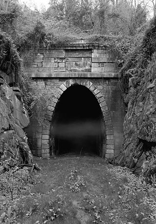
The Blue Ridge Tunnel is a historic railroad tunnel built during the construction of the Blue Ridge Railroad in the 1850s. The tunnel was the westernmost and longest of four tunnels engineered by Claudius Crozet to cross the Blue Ridge Mountains at Rockfish Gap in central Virginia.

The James River and Kanawha Canal was a partially built canal in Virginia intended to facilitate shipments of passengers and freight by water between the western counties of Virginia and the coast. Ultimately its towpath became the roadbed for a rail line following the same course.
The Western Maryland Railway was an American Class I railroad (1852–1983) that operated in Maryland, West Virginia, and Pennsylvania. It was primarily a coal hauling and freight railroad, with a small passenger train operation.
Buckingham Branch Railroad is a Class III short-line railroad operating over 275 miles (443 km) of historic and strategic trackage in Central Virginia. Sharing overhead traffic with CSX and Amtrak, the company's headquarters are in Dillwyn, Virginia in the former Chesapeake and Ohio Railway (C&O) station, itself a historic landmark in the community.

Covington and Ohio Railroad was part of a planned railroad link between Eastern Virginia and the Ohio River in the 1850s. The mountainous region of the Allegheny Front of the Appalachian Plateau between an existing canal, railroads and navigable rivers represented a formidable obstacle.

The Sciotoville Bridge is a steel continuous truss bridge carrying CSX Transportation railroad tracks across the Ohio River between Siloam - a junction located north of Limeville, Kentucky and east of South Shore, Kentucky - and Sciotoville, Ohio in the United States. Designed by Gustav Lindenthal, the bridge was constructed in 1916 by Chesapeake and Ohio Railway subsidiary Chesapeake and Ohio Northern Railway as part of a new route between Ashland, Kentucky and Columbus, Ohio.

The CSX Susquehanna River Bridge is a railroad bridge that carries CSX's Philadelphia Subdivision across the Susquehanna River between Havre de Grace and Perryville, Maryland, via Garrett Island. It was built in 1907–1910 by the Baltimore and Ohio Railroad (B&O) on the same alignment as an 1886 B&O bridge. Like its predecessor, it was the longest continuous bridge on the B&O system.

The Clay Wade Bailey Bridge is a cantilever bridge carrying U.S. Route 42 and U.S. Route 127 across the Ohio River, connecting Cincinnati, Ohio and Covington, Kentucky. It also carries U.S. Route 25, the northern terminus of which is the Ohio state line, at the historic low-water mark of the Ohio River. The bridge's main span is 675 feet (206 m). It is a 3-lane bridge; Two lanes are dedicated to travel each way and the middle lane is a reversible lane, meaning the direction of travel of the middle lane changes according to the time of day.

The Big Four Bridge is a six-span truss bridge that crosses the Ohio River, connecting Louisville, Kentucky, and Jeffersonville, Indiana. It was completed in 1895, updated in 1929, taken out of rail service in 1968, and converted to bicycle and pedestrian use in 2013. The largest single span is 547 feet (167 m); the entire bridge spans 2,525 feet (770 m). It took its name from the defunct Cleveland, Cincinnati, Chicago and St. Louis Railway, which was nicknamed the "Big Four Railroad".

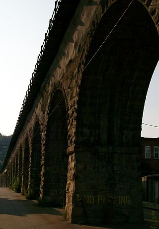
The Thomas Viaduct is a viaduct that spans the Patapsco River and Patapsco Valley between Relay, Maryland and Elkridge, Maryland, USA. It was commissioned by the Baltimore and Ohio Railroad (B&O); built between July 4, 1833, and July 4, 1835; and named for Philip E. Thomas, the company's first president. Some claim it to be the world's oldest multiple arched stone railroad bridge. However, the Sankey Viaduct on the Liverpool and Manchester Railway was opened in 1830 and finally completed in 1833.

The Ohio Connecting Railroad Bridge is a steel bridge which crosses the Ohio River at Brunot's Island at the west end of Pittsburgh, Pennsylvania, United States. It consists of two major through truss spans over the main and back channels of the river, of 508 feet (155 m) and 406 feet (124 m) respectively, with deck truss approaches.

The Triple Crossing in Richmond, Virginia is one of two places in North America where three railroad lines cross at different levels at the same spot, the other being the BNSF operated Santa Fe Junction in Kansas City. Santa Fe Junction became a triple crossing after the Argentine Connection was completed in 2004.

The Parkersburg Bridge crosses the Ohio River between Parkersburg, West Virginia, and Belpre, Ohio. Designed by Jacob Linville, the bridge has 46 spans: 25 deck plate girder, 14 deck truss, 6 through truss, and 1 through plate girder. 50,000 cubic yards (38,000 m3) of stone were used for the 53 piers. The bridge was constructed from May 1869 to January 1871 by the Baltimore and Ohio Railroad. At the time of its completion, the bridge was reportedly the longest in the world at 7,140 feet (2,180 m).
B & O Railroad Viaduct is a historic structure in Bellaire, Ohio, listed in the National Register of Historic Places on June 22, 1976.

The B & O Railroad Potomac River Crossing is a 15-acre (6.1 ha) historic site where a set of railroad bridges, originally built by the Baltimore and Ohio Railroad, span the Potomac River between Sandy Hook, Maryland and Harpers Ferry, West Virginia. The site was added to the National Register of Historic Places on February 14, 1978, for its significance in commerce, engineering, industry, invention, and transportation.

Transportation in Cincinnati includes sidewalks, roads, public transit, bicycle paths, and regional and international airports. Most trips are made by car, with transit and bicycles having a relatively low share of total trips; in a region of just over 2 million people, less than 80,000 trips are made with transit on an average day. The city is sliced by three major interstate highways, I-71, I-74 and I-75, and circled by a beltway several miles out from the city limits. The region is served by two separate transit systems, one on each side of the river. SORTA, on the Ohio side is about six times larger than TANK on the Kentucky side.

