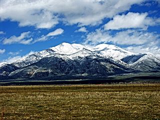
Taos County is a county in the U.S. state of New Mexico. As of the 2010 census, the population was 32,937. Its county seat is Taos. The county was formed in 1852 as one of the original nine counties in New Mexico Territory.

Santa Fe County is a county in the U.S. state of New Mexico. As of the 2010 census, the population was 144,170, making it New Mexico's third-most populous county, after Bernalillo County and Doña Ana County. Its county seat is Santa Fe, the state capital.

Rio Arriba County is a county in the U.S. state of New Mexico. As of the 2010 census, the population was 40,246. Its county seat is Tierra Amarilla. Its northern border is the Colorado state line.

Mora County is a county in the US state of New Mexico. As of the 2010 census, the population was 4,881. Its county seat is the census-designated place (CDP) Mora. The county has another CDP, Watrous, a village, Wagon Mound, New Mexico, and 12 smaller unincorporated settlements. Mora became a formal county in the US, in what was then the New Mexico Territory, on February 1, 1860. Ecclesiastically, the county is within the Roman Catholic Archdiocese of Santa Fe. County population peaked at about 14,000 around 1920, declining to about 4,000 to 5,000 since the 1970s; the 2016 estimate was 4,500.

The Mexican Cession is the region in the modern-day southwestern United States that Mexico ceded to the U.S. in the Treaty of Guadalupe Hidalgo in 1848 after the Mexican–American War. This region had not been part of the areas east of the Rio Grande which had been claimed by the Republic of Texas, though the Texas annexation resolution two years earlier had not specified the southern and western boundary of the new State of Texas. The Mexican Cession was the third largest acquisition of territory in US history. The largest was the Louisiana Purchase, with some 827,000 sq. miles, followed by the acquisition of Alaska.
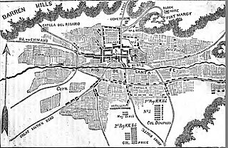
The Capture of Santa Fe, also known as the Battle of Santa Fe or the Battle of Cañoncito, took place near Santa Fe, New Mexico, the capital of the Mexican Province of New Mexico, during the Mexican–American War on 8 August through 14 August 1846. No shots were fired during the capturing of Santa Fe.

The Mexico–United States border is an international border separating Mexico and the United States, extending from the Pacific Ocean in the west to the Gulf of Mexico in the east. The border traverses a variety of terrains, ranging from urban areas to deserts. The Mexico–US border is the most frequently crossed border in the world, with approximately 350 million documented crossings annually.

Tohajiilee, Cañoncito Band of Navajos is a non-contiguous section of the Navajo Nation lying in parts of western Bernalillo, eastern Cibola, and southwestern Sandoval counties in the U.S. state of New Mexico, west of the city of Albuquerque. It is a Navajo phrase roughly translated in English as "Dipping Water".

Joseph Horace Eaton was an American artist and a career officer in the United States Army. He served as a major during the American Civil War. In recognition of his service, in 1866 he was nominated and in 1867 he was confirmed for appointment to the grade of brevet brigadier general in the regular army to rank from March 13, 1865.

The Mexican–American War, also known in the United States as the Mexican War and in Mexico as the American intervention in Mexico, was an armed conflict between the United States of America and the United Mexican States (Mexico) from 1846 to 1848. It followed in the wake of the 1845 American annexation of the independent Republic of Texas. The unstable Mexican caudillo leadership of President/General Antonio López de Santa Anna still considered Texas to be a northeastern province and never recognized the Republic of Texas, which had seceded a decade earlier. In 1845, newly elected U.S. President James K. Polk sent troops to the disputed area and a diplomatic mission to Mexico. After Mexican forces attacked American forces, Polk cited this in his request that Congress declare war.

The Ortiz Mountains are a mountain range in north central New Mexico, United States, in Santa Fe County, northeast of the Sandia Mountains and due north of the San Pedro Mountains. The Ortiz include Placer Peak, the highest peak in the range at 8,858 feet, Lone Mountain at 7,310 feet, Cedar Mountain at 7,041 feet, Cerro Chato at 6,965 feet, and the foothills known as the Los Lomas de la Bolsa.

Nuestra Senora de Luz Church and Cemetery is a historic church building 13 miles southeast of Santa Fe, north of Interstate 25 frontage road in Canoncito, New Mexico.
Cañoncito or Canoncito may refer to the following places in the U.S. state of New Mexico:

Cañoncito is an unincorporated community in Rio Arriba County, New Mexico, United States. Cañoncito is located on Embudo Creek 3.4 miles (5.5 km) east-southeast of Dixon.
Cañoncito is an unincorporated community in Taos County, New Mexico, United States. Cañoncito is 10 miles (16 km) north-northwest of Taos.
Cañoncito is an unincorporated community in Santa Fe County, New Mexico, United States. Cañoncito is located on Interstate 25, 11.5 miles (18.5 km) southeast of Santa Fe. Nuestra Señora de Luz Church and Cemetery, which is listed on the National Register of Historic Places, is located in Cañoncito.
Canoncito is an unincorporated community in Mora County, New Mexico, United States. Canoncito is located along New Mexico State Road 518 25 miles (40 km) north of Las Vegas.
Canoncito is an unincorporated community in San Miguel County, New Mexico, United States. Canoncito is 15.2 miles (24.5 km) north-northwest of Las Vegas.