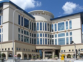
Bernalillo County is the most populous county in the U.S. state of New Mexico. As of the 2020 census, the population was 676,444. The county seat, Albuquerque, is the most populous city in New Mexico.

Carnuel is a census-designated place (CDP) in Bernalillo County, New Mexico, United States. The population was 1,232 at the 2010 Census. It is part of the Albuquerque Metropolitan Statistical Area. Robert Julyan theorizes that name of the community, which has been spelled both Carnuel and Carnué, derives from the Tiwa word for "badger place."

Cedar Crest is a census-designated place (CDP) in Bernalillo County, New Mexico, United States. The population was 958 at the 2010 census. It is part of the Albuquerque Metropolitan Statistical Area.

Chilili is a census-designated place in Bernalillo County, New Mexico, United States. The population was 137 at the 2010 census. It is part of the Albuquerque Metropolitan Statistical Area.

Isleta Village Proper is a census-designated place (CDP) in Bernalillo County, New Mexico, United States. The population was 491 at the 2010 census. It is part of the Albuquerque Metropolitan Statistical Area.

South Valley is a census-designated place (CDP) and town in Bernalillo County, New Mexico, United States. The population was 40,976 at the 2010 Census. It is part of the Albuquerque Metropolitan Statistical Area. The U.S. Postal Service uses "Albuquerque" for all South Valley addresses.

Algodones is a census-designated place (CDP) in Sandoval County, New Mexico, United States. The population was 814 at the 2010 census. It is part of the Albuquerque Metropolitan Statistical Area.
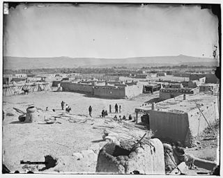
Cochiti is a census-designated place (CDP) in Sandoval County, New Mexico, United States. A historic pueblo of the Cochiti people, one of the Keresan Nations, it is part of the Albuquerque Metropolitan Statistical Area. The population was 528 at the 2010 census. Located 22 miles (35 km) southwest of Santa Fe, the community is listed as a historic district on the National Register of Historic Places.

San Felipe Pueblo is a census-designated place (CDP) in Sandoval County, New Mexico, United States, and is located 10 miles (16 km) north of Bernalillo. As of the 2000 census, the CDP population was 2,080. It is part of the Albuquerque Metropolitan Statistical Area.

Santa Ana Pueblo is a census-designated place (CDP) in Sandoval County, New Mexico, United States. As of the 2000 census, the CDP had a total population of 479. It is part of the Albuquerque Metropolitan Statistical Area. The Pueblo, named Tamaya in Keres, administers a total reservation land of 73,000 acres (295 km2) in the Rio Grande valley and is composed of Native Americans who speak an eastern dialect of the Keresan languages.

Cedro is a census-designated place (CDP) in Bernalillo County, New Mexico, United States. The population was 430 at the 2010 census. It is part of the Albuquerque Metropolitan Statistical Area.
Edith Enclave is a census-designated place (CDP) in Bernalillo County, New Mexico, United States. The population was 211 at the 2010 census. It is part of the Albuquerque Metropolitan Statistical Area.
Manzano Springs is a census-designated place (CDP) in Torrance and Bernalillo counties, New Mexico, United States. The population was 137 at the 2010 census. It is part of the Albuquerque Metropolitan Statistical Area.
Paradise Hills is a census-designated place (CDP) in Bernalillo County, New Mexico, United States. The population was 4,256 at the 2010 census. It is part of the Albuquerque Metropolitan Statistical Area.
Ponderosa Pine is a census-designated place (CDP) in Bernalillo County, New Mexico, United States. The population was 1,195 at the 2010 census. It is part of the Albuquerque Metropolitan Statistical Area.
Sandia Heights is a census-designated place (CDP) in Bernalillo County, New Mexico, United States. The population was 10,293 at the 2010 census. It is part of the Albuquerque Metropolitan Statistical Area.
Sandia Knolls is a census-designated place (CDP) in Bernalillo County, New Mexico, United States. The population was 1,208 at the 2010 census. It is part of the Albuquerque Metropolitan Statistical Area.
Barton is a census-designated place (CDP) in Bernalillo and Santa Fe counties, New Mexico, United States. It was first listed as a CDP prior to the 2020 census.
Paa-Ko is a census-designated place (CDP) in Bernalillo County, New Mexico, United States, built around the Paa-Ko Ridge Golf Club. It was first listed as a CDP prior to the 2020 census.
Rio Rancho Estates is an unincorporated community and census-designated place (CDP) in Sandoval County, New Mexico, United States. It was first listed as a CDP prior to the 2020 census.

