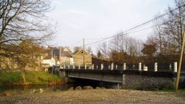
Cahan, Orne

Last updated

Cahan
Cahan pont.JPG
The bridge in Cahan
Location of Cahan
Cahan, Orne
France location map-Regions and departements-2016.svg
Red pog.svg
Cahan
Normandie region location map.svg
Red pog.svg
Cahan
Coordinates: 48°51′35″N0°26′31″W / 48.8597°N 0.4419°W / 48.8597; -0.4419
Country France
Region Normandy
Department Orne
Arrondissement Argentan
Canton Athis-Val de Rouvre
Intercommunality CA Flers Agglo
Government
  Mayor (20202026) Xavier De Saint Pol [1]
Area
1
5.87 km2 (2.27 sq mi)
Population
 (2021) [2]
163
  Density28/km2 (72/sq mi)
Time zone UTC+01:00 (CET)
  Summer (DST) UTC+02:00 (CEST)
INSEE/Postal code
61069 /61430
Elevation50–242 m (164–794 ft)
(avg. 140 m or 460 ft)
1 French Land Register data, which excludes lakes, ponds, glaciers > 1 km2 (0.386 sq mi or 247 acres) and river estuaries.

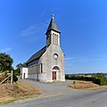
Cahan is a commune in the Orne department in north-western France.

Contents

Geography

The commune is part of the area known as Suisse Normande. [3]

The commune is made up of the following collection of villages and hamlets, Fourneaux,La Bijude, Le Haut Vardon, Le Bas Vardon and Cahan. [4]

The Commune with another 20 communes shares part of a 2,115 hectare, Natura 2000 conservation area, called the Vallée de l'Orne et ses affluents. [5]

The commune has 2 watercourses running through it the river Noireau and 1 stream the Mare des Bois.

Population

Historical population
YearPop.±% p.a.
1968 250    
1975 205−2.80%
1982 223+1.21%
1990 211−0.69%
1999 187−1.33%
2007 203+1.03%
2012 155−5.25%
2017 181+3.15%
Source: INSEE [6]

See also

Related Research Articles

<span class="mw-page-title-main">Le Bô</span> Commune in Normandy, France

Le Bô is a commune in the Calvados department in the Normandy region in northwestern France.

<span class="mw-page-title-main">Cossesseville</span> Commune in Normandy, France

Cossesseville is a commune in the Calvados department in the Normandy region in northwestern France.

<span class="mw-page-title-main">Les Isles-Bardel</span> Commune in Normandy, France

Les Isles-Bardel is a commune in the Calvados department in the Normandy region in northwestern France. The commune is where the Baize joins the river Orne.

<span class="mw-page-title-main">Le Mesnil-Villement</span> Commune in Normandy, France

Le Mesnil-Villement is a commune in the Calvados department in the Normandy region in northwestern France.

<span class="mw-page-title-main">Pierrefitte-en-Cinglais</span> Commune in Normandy, France

Pierrefitte-en-Cinglais is a commune in the Calvados department in the Normandy region in northwestern France.

<span class="mw-page-title-main">Pont-d'Ouilly</span> Commune in Normandy, France

Pont-d'Ouilly is a commune in the Calvados department in the Normandy region in northwestern France.

<span class="mw-page-title-main">Rapilly</span> Commune in Normandy, France

Rapilly is a commune in the Calvados department in the Normandy région in northwestern France. The commune is where the Baize joins the river Orne.

<span class="mw-page-title-main">Saint-Rémy, Calvados</span> Commune in Normandy, France

Saint Rémy is a commune in the Calvados department in the Normandy region in northwestern France. Until 1968 an iron mine was exploited in the village.

<span class="mw-page-title-main">Le Vey</span> Commune in Normandy, France

Le Vey is a commune in the Calvados department in the Normandy region in northwestern France.

<span class="mw-page-title-main">Ménil-Hermei</span> Commune in Normandy, France

Ménil-Hermei is a commune in the Orne department in the Normandy region of north-western France.

<span class="mw-page-title-main">Ménil-Hubert-sur-Orne</span> Commune in Normandy, France

Ménil-Hubert-sur-Orne is a commune in the Orne department in north-western France.

<span class="mw-page-title-main">Saint-Hilaire-de-Briouze</span> Commune in Normandy, France

Saint-Hilaire-de-Briouze is a commune in the Orne department in north-western France.

<span class="mw-page-title-main">Saint-Philbert-sur-Orne</span> Commune in Normandy, France

Saint-Philbert-sur-Orne is a commune in the Orne department in north-western France.

<span class="mw-page-title-main">Giel-Courteilles</span> Commune in Normandy, France

Giel-Courteilles is a commune in the Orne department in north-western France. The current commune was formed in 1965 when the two communes of Giel and Courteilles merged.

<span class="mw-page-title-main">Les Yveteaux</span> Commune in Normandy, France

Les Yveteaux is a commune in the Orne department in north-western France.

<span class="mw-page-title-main">Berjou</span> Commune in Normandy, France

Berjou is a commune in the Orne department in northwestern France.

<span class="mw-page-title-main">Athis-Val de Rouvre</span> Commune in Normandy, France

Athis-Val de Rouvre is a commune in the department of Orne, northwestern France, the municipality was established on 1 January 2016 by merger of the former communes of Athis-de-l'Orne, Bréel, La Carneille, Notre-Dame-du-Rocher, Ronfeugerai, Ségrie-Fontaine, Taillebois and Les Tourailles.

<span class="mw-page-title-main">Écouché-les-Vallées</span> Commune in Normandy, France

Écouché-les-Vallées is a commune in the department of Orne, northwestern France. The municipality was established on 1 January 2016 by merger of the former communes of Batilly, La Courbe, Écouché, Loucé, Saint-Ouen-sur-Maire and Serans. On 1 January 2018, the former commune of Fontenai-sur-Orne was merged into Écouché-les-Vallées. It's seat, Écouché, is classed as a Petites Cités de Caractère.

<span class="mw-page-title-main">Putanges-le-Lac</span> Commune in Normandy, France

Putanges-le-Lac is a commune in the department of Orne, northwestern France. The municipality was established on 1 January 2016 by merger of the former communes of Chênedouit, La Forêt-Auvray, La Fresnaye-au-Sauvage, Ménil-Jean, Putanges-Pont-Écrepin, Rabodanges, Les Rotours, Saint-Aubert-sur-Orne and Sainte-Croix-sur-Orne.

<span class="mw-page-title-main">Monts-sur-Orne</span> Commune in Normandy, France

Monts-sur-Orne is a commune in the department of Orne, northwestern France. The municipality was established on 1 January 2018 by merger of the former communes of Goulet, Montgaroult and Sentilly.

References

  1. "Répertoire national des élus: les maires". data.gouv.fr, Plateforme ouverte des données publiques françaises (in French). 9 August 2021.
  2. "Populations légales 2021" (in French). The National Institute of Statistics and Economic Studies. 28 December 2023.
  3. "Map of Suisse Normande" (PDF).
  4. 1 2 "Google Maps". Google Maps.
  5. "INPN - FSD Natura 2000 - FR2500091 - Vallée de l'Orne et ses affluents - Description".
  6. Population en historique depuis 1968, INSEE