
Charleston is the largest city in the U.S. state of South Carolina, the county seat of Charleston County, and the principal city in the Charleston–North Charleston metropolitan area. The city lies just south of the geographical midpoint of South Carolina's coastline on Charleston Harbor, an inlet of the Atlantic Ocean formed by the confluence of the Ashley, Cooper, and Wando rivers. Charleston had a population of 150,277 as of the 2020 U.S. Census. The 2020 population of the Charleston metropolitan area, comprising Berkeley, Charleston, and Dorchester counties, was 799,636 residents, the third-largest in the state and the 74th-largest metropolitan statistical area in the United States.

Morganton is a city in and the county seat of Burke County, North Carolina, United States. The population was 16,918 at the 2010 census. Morganton is approximately 240 miles (390 km) northeast of Atlanta, Georgia.

Wakefield is a village in the town of South Kingstown, Rhode Island, United States, and the commercial center of South Kingstown. Together with the village of Peace Dale, it is treated by the U.S. Census as a component of the census-designated place identified as Wakefield-Peacedale, Rhode Island. West Kingston, another South Kingstown village, was the traditional county seat of Washington County. Since 1991, the Washington County Courthouse has been in Wakefield. The Sheriff's Office which handles corrections is also in Wakefield.
The Cherokee Path was the primary route of English and Scots traders from Charleston to Columbia, South Carolina in Colonial America. It was the way they reached Cherokee towns and territories along the upper Keowee River and its tributaries. In its lower section it was known as the Savannah River. They referred to these towns along the Keowee and Tugaloo rivers as the Lower Towns, in contrast to the Middle Towns in Western North Carolina and the Overhill Towns in present-day southeastern Tennessee west of the Appalachian Mountains.
Daniel Island, South Carolina is a 4,000-acre (16 km2) island located in the city of Charleston, South Carolina, United States. Named after its former inhabitant, the colonial governor of the Carolinas, Robert Daniell, the island is located in Berkeley County and situated between the Cooper and Wando Rivers. As of July 2012 it is being developed as a master-planned community complete with residential neighborhoods, parks, trails, recreational amenities and a downtown that is home to shops, restaurants, schools, churches and offices for businesses.
The following is a list of Registered Historic Places in Iron County, Michigan. The list includes 79 structures and historic districts that are significant for their architectural, historical, or industrial/economic importance.
The South Carolina civil disturbances of 1876 were a series of race riots and civil unrest related to the Democratic Party's political campaign to take back control from Republicans of the state legislature and governor's office through their paramilitary Red Shirts division. Part of their plan was to disrupt Republican political activity and suppress black voting, particularly in counties where populations of whites and blacks were close to equal. Former Confederate general Martin W. Gary's "Plan of the Campaign of 1876" gives the details of planned actions to accomplish this.

Galivants Ferry is an unincorporated community in Horry County, South Carolina, United States. It lies on the Little Pee Dee River west of Aynor on U.S. Route 501.

Huger is an unincorporated community in Berkeley County, South Carolina, United States. It is part of the Charleston–North Charleston–Summerville Metropolitan Statistical Area.
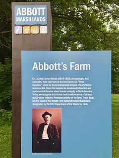
The Abbott Farm Historic District is a National Historic Landmark archaeological site in New Jersey. It is the largest known Middle Woodland village of its type on the East Coast of the United States. Significant evidence suggests that the Delaware River floodplain was occupied by Paleoindian people for a long period. It was inhabited between 500 BC and 500 AD. It has been a source of controversy and debate around early development.

Beaufort Historic District is a historic district in Beaufort, South Carolina. It was listed on the National Register of Historic Places in 1969, and was declared a National Historic Landmark in 1973.

The Charleston Historic District, alternatively known as Charleston Old and Historic District, is a National Historic Landmark District in Charleston, South Carolina. The district, which covers most of the historic peninsular heart of the city, contains an unparalleled collection of 18th and 19th-century architecture, including many distinctive Charleston "single houses". It was declared a National Historic Landmark in 1960.

Middleburg Plantation is a historic colonial-era plantation on the Cooper River near Huger, South Carolina. The plantation house, built in 1697 by the French Huguenot Benjamin Simons, is probably the oldest standing wood-frame building in South Carolina, and is consequently an architecturally important example of period construction. It was declared a National Historic Landmark in 1970.

This is a list of the National Register of Historic Places listings in Charleston County, South Carolina.

Strawberry Chapel is a parochial chapel of ease in the lower part of St. John's, Berkeley Parish in Berkeley County, South Carolina that was built in 1725. It is on Strawberry Chapel Road between South Carolina State Highway 8-44 and the West Branch of the Cooper River. Bordering Strawberry's property is the South Carolina State owned historic site of the “Town of Childsbury.” It was a planned community that was settled in 1707. The town no longer exists. They were named to the National Register of Historic Places on April 26, 1972.

White Church, also known as The Brick Church, and formally as St. Thomas Episcopal Church and St. Thomas and St. Dennis Parish Church, is a historic church north of Cainhoy in Berkeley County, South Carolina.
Pinopolis Historic District North is a national historic district located at Pinopolis, Berkeley County, South Carolina. It encompasses six contributing buildings on four of the 19th century retreats that helped to engender Pinopolis. The vernacular houses are uniformly of frame construction and abstain from the stylistic pretensions of the permanent planters' seats of the period in accord with their status as houses of retreat. The buildings in the district date from about 1834 to about 1883 and retain in large measure their original forms and features. The district's landscape is unified by the absence of contemporary buildings, heavy foliage, the absence of paved roads, and the cohesiveness of the four residences which are weatherboarded with large porches, reflecting the Queen Anne style.
Pinopolis Historic District South is a national historic district located at Pinopolis, Berkeley County, South Carolina. It encompasses 12 contributing buildings and consists of the historic core of the planters retreat community of Pinopolis. The district contains numerous early to middle-19th century summer houses, the Gothic Revival influenced Pinopolis Methodist Church, and other later 19th century buildings including some in the Queen Anne style. The buildings of the Pinopolis Historic District South are representative of the development of vernacular building forms and construction technology of the 19th century. The absence of stylistic pretensions in most of the buildings is typical of pineland village architecture.

Pineville Historic District is a national historic district located at Pineville, Berkeley County, South Carolina. It encompasses seven contributing buildings and illustrates Pineville's original role as a 19th-century pineland village, and its gradual transformation to agricultural land and to a year-round community in the late-19th and early-20th centuries. The Pineville Historic District consists of four principal buildings, three residential buildings and one Episcopal church, ranging in date from about 1810 through 1925. The architectural styles represented include Federal, Greek Revival, and Bungalow. In the mid to late-19th century, Pineville was a densely settled village that included as many as one hundred buildings, including an academy, racetrack, library, churches, and residences. Much of the town was burned by Union troops at the close of the American Civil War in April 1865. In the years following the war, much of the land that made up the village was converted for use as farmland. Since that time, Pineville has remained a small community of less than 20 structures surrounded by open farm and hunting lands.
Cooper River Historic District is a national historic district located along the East and West Branches of the Cooper River near Moncks Corner, Berkeley County, South Carolina. It encompasses 32 contributing buildings, 77 contributing sites, 8 contributing structures, and 4 contributing objects and is a remarkably intact historic and cultural landscape. The district includes many historic buildings, structures, and objects from the 18th, 19th, and 20th centuries and archaeological remains of settlements, machines, barns, and other structures that supported agricultural activity. In addition, there are landscape features dating to the 18th and 19th centuries such as rice fields, banks, canals, dams, reservoirs or reserves, causeways, roads, avenues, upland fields, fence lines, and cemeteries.


