Chaparral is a shrubland or heathland plant community found primarily in the U.S. state of California and in the northern portion of the Baja California Peninsula, Mexico. It is shaped by a Mediterranean climate and wildfire, featuring summer-drought-tolerant plants with hard sclerophyllous evergreen leaves, as contrasted with the associated soft-leaved, drought-deciduous, scrub community of coastal sage scrub, found below the chaparral biome. Chaparral covers 5% of the state of California, and associated Mediterranean shrubland an additional 3.5%. The name comes from the Spanish word for scrub oak, chaparro.
The California chaparral and woodlands is a terrestrial ecoregion of lower northern, central, and southern California and northwestern Baja California (Mexico), located on the west coast of North America. It is an ecoregion of the Mediterranean forests, woodlands, and scrub biome, and part of the Nearctic realm.

The ecology of California can be understood by dividing the state into a number of ecoregions, which contain distinct ecological communities of plants and animals in a contiguous region. The ecoregions of California can be grouped into four major groups: desert ecoregions, Mediterranean ecoregions, forested mountains, and coastal forests.

Mount Tamalpais is a peak in Marin County, California, United States, often considered symbolic of Marin County. Much of Mount Tamalpais is protected within public lands such as Mount Tamalpais State Park, the Marin Municipal Water District watershed, and National Park Service land, such as Muir Woods.

The Northern California coastal forests are a temperate coniferous forests ecoregion of coastal Northern California, USA.

The Shasta–Trinity National Forests are federally designated forests in northern California, United States. Combined, they are the largest National Forest in California and are managed by the U.S. Forest Service. The 2,210,485 acre combined-forest encompasses five wilderness areas, hundreds of mountain lakes and 6,278 miles (10,103 km) of streams and rivers. Major features include Shasta Lake, the largest man-made lake in California and Mount Shasta, elevation 14,179 feet (4,322 m).

The Golden Gate Biosphere is a biosphere reserve in Northern California. It was created by UNESCO in 1988 and encompasses 13 protected areas in the San Francisco Bay Area. It extends through the central California coastal region from the Bodega Marine Reserve in the north to Jasper Ridge in the south and includes the Farallon Islands, Angel Island, and Alcatraz within the San Francisco Bay. The biosphere reserve is situated on both sides of the San Andreas Fault. Each side has a completely different type of bedrock, and the western side of the rift is moving northward. It encompasses a diverse range of marine, coastal, and upland habitats of the California chaparral and woodlands and Northern California coastal forests ecoregions, including mixed evergreen forests, Coast Redwood forests, Douglas-fir forests, Bishop pine forests, oak forests, woodlands and savannas, northern coastal scrub, chaparral, coastal dune, coastal strand, tidepools, kelp forests, coastal grasslands, and marshes. The associated fauna is also rich with cougars, Tule elk, California sea lions, elephant seals, and many shorebirds.

California mixed evergreen forest is an plant community found in the mountain ranges of California and southwestern Oregon.

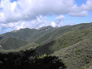
The Coast Ranges of California span 400 miles (644 km) from Del Norte or Humboldt County, California, south to Santa Barbara County. The other three coastal California mountain ranges are the Transverse Ranges, Peninsular Ranges and the Klamath Mountains.

The California Floristic Province (CFP) is a floristic province with a Mediterranean-type climate located on the Pacific Coast of North America with a distinctive flora similar to other regions with a winter rainfall and summer drought climate like the Mediterranean Basin. This biodiversity hotspot is known for being the home of the Sierran giant sequoia tree and its close relative the coast redwood. In 1996, the Province was designated as a biodiversity hotspot allowing it to join ranks among 33 other areas in the world with many endemic species. To be named a biodiversity hotspot, an area has to contain species and plant life that cannot be found anywhere else in the world. The California Floristic Province is home to over 3,000 species of vascular plants, 60% of which are endemic to the province.

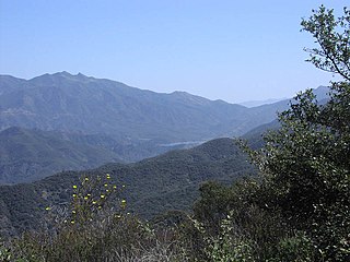
The Big Sur River is a 15.7-mile-long (25.3 km) river on the Central Coast of California. The river drains a portion of the Big Sur area, a thinly settled region of the Central California coast where the Santa Lucia Mountains rise abruptly from the Pacific Ocean. The upper river and watershed lies within the Ventana Wilderness and encompasses the headwaters downstream to the area known as the Gorge. The lower river runs through Pfeiffer Big Sur State Park, the Big Sur village, several private camp grounds and Andrew Molera State Park where it flows through a lagoon to the Monterey Bay National Marine Sanctuary in the Pacific Ocean. It flows roughly northwest and empties into the ocean, where there is a natural sandbar that has created a lagoon. Major Tributaries of the river include, in order: Redwood Creek, Lion Creek, Logwood Creek, Terrace Creek, Ventana Creek, Post Creek, Pfeiffer-Redwood Creek, Juan Higuera Creek, and Pheneger Creek.

California oak woodland is a plant community found throughout the California chaparral and woodlands ecoregion of California in the United States and northwestern Baja California in Mexico. Oak woodland is widespread at lower elevations in coastal California; in interior valleys of the Coast Ranges, Transverse Ranges and Peninsular Ranges; and in a ring around the California Central Valley grasslands. The dominant trees are oaks, interspersed with other broadleaf and coniferous trees, with an understory of grasses, herbs, geophytes, and California native plants.
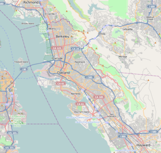
Huckleberry Botanic Regional Preserve is a 241 acres (0.98 km2) regional park and nature reserve in the Oakland Hills, in the eastern East Bay region of the San Francisco Bay Area of California. It is within Alameda and Contra Costa Counties. It is a park within the East Bay Regional Parks District system. The Preserve is named after the California Huckleberry which grows abundantly within its habitat.

The Landels-Hill Big Creek Reserve is a constituent of the University of California Natural Reserve System. It is located off State Route 1 in the Big Sur area on California's central coast, fifty miles south of Monterey and adjacent to the Big Creek State Marine Reserve and Big Creek State Marine Conservation Area.

The Klamath Mountains ecoregion of Oregon and California lies inland and north of the Coast Range ecoregion, extending from the Umpqua River in the north to the Sacramento Valley in the south. It encompasses the highly dissected ridges, foothills, and valleys of the Klamath and Siskiyou Mountains. It corresponds to the Level III ecoregion designated by the Environmental Protection Agency and to the Klamath-Siskiyou forests ecoregion designated by the World Wide Fund for Nature.

The California coastal sage and chaparral, a sub-ecoregion of the California chaparral and woodlands ecoregion, is found in southwestern California and northwestern Baja California in Mexico.

The California montane chaparral and woodlands is an ecoregion defined by the World Wildlife Fund, spanning 7,900 square miles (20,000 km2) of mountains in the Transverse Ranges, Peninsular Ranges, and Coast Ranges of southern and central California. The ecoregion is part of the larger California chaparral and woodlands ecoregion, and belongs to the Mediterranean forests, woodlands, and scrub biome.
The California interior chaparral and woodlands ecoregion covers 24,900 square miles (64,000 km2) in an elliptical ring around the California Central Valley. It occurs on hills and mountains ranging from 300 feet (91 m) to 3,000 feet (910 m). It is part of the Mediterranean forests, woodlands, and scrub biome, with cool, wet winters and hot, dry summers. Many plant and animal species in this ecoregion are adapted to periodic fire.
The Angelo Coast Range Reserve is located in the Northern Outer California Coast Ranges, in Mendocino County, Northern California. The 7,660-acre reserve includes a section of the Eel River.

The San Dimas Biosphere Reserve and Experimental Forest is an experimental forest located in the front range of the San Gabriel Mountains of southern California. San Dimas constitutes a protected field laboratory jointly managed by the Angeles National Forest and the Pacific Southwest Research Station of the United States Forest Service under the designation San Dimas Experimental Forest. It was designated as a UNESCO Biosphere Reserve in 1976 and withdrawn from the programme in July 2018.
