Calke Abbey is a Grade I listed country house near Ticknall, Derbyshire, England, in the care of the charitable National Trust.

Breedon on the Hill is a village and civil parish about 5 miles (8 km) north of Ashby-de-la-Zouch in North West Leicestershire, England. The parish adjoins the Derbyshire county boundary and the village is only about 2 miles (3 km) south of the Derbyshire town of Melbourne. The 2001 Census recorded a parish population of 958 people in 404 households. The parish includes the hamlets of Tonge 1 mile (1.6 km) east of the village and Wilson 1.3 miles (2 km) north of the village on the county boundary. The population at the 2011 census was 1,029 in 450 households.
Moira is a former mining village about 2.5 miles (4 km) south-west of Ashby-de-la-Zouch in North West Leicestershire, England. The village is about 3 miles (5 km) south of Swadlincote and is close to the boundary with Derbyshire. The population is included in the civil parish of Ashby Woulds.

The Ashby-de-la-Zouch Canal is a 31-mile (50 km) long canal in England which connected the mining district around Moira, just outside the town of Ashby-de-la-Zouch in Leicestershire, with the Coventry Canal at Bedworth in Warwickshire. It was opened in 1804, and a number of tramways were constructed at its northern end, to service collieries. The canal was taken over by the Midland Railway in 1846, but remained profitable until the 1890s, after which it steadily declined. Around 9 miles (14 km) passed through the Leicestershire coal field, and was heavily affected by subsidence, with the result that this section from Moira, southwards to Snarestone, was progressively closed in 1944, 1957 and 1966, leaving 22 miles (35 km) of navigable canal.

The National Forest is an environmental project in central England run by The National Forest Company. From the 1990s, 200 square miles (520 km2) of north Leicestershire, south Derbyshire and southeast Staffordshire have been planted in an attempt to blend ancient woodland with newly planted areas to create a new national forest. It stretches from the western outskirts of Leicester in the east to Burton upon Trent in the west, and is planned to link the ancient forests of Needwood and Charnwood.

Donisthorpe is a village in the North West Leicestershire district of Leicestershire, England, historically an exclave of Derbyshire.

North West Leicestershire is a local government district in Leicestershire, England. The towns in the district include of Ashby-de-la-Zouch, Castle Donington, Coalville and Ibstock. Notable villages in the district include Donington le Heath, Ellistown, Hugglescote, Kegworth, Measham, Shackerstone, Thringstone and Whitwick.

Wycomb is a small hamlet in the district of Melton, which is approximately 4 miles (6.4 km) northeast of Melton Mowbray in Leicestershire, and is part of the civil parish of Scalford, which also includes the neighbouring village of Chadwell. Until 1 April 1936 it was in the parish of Wycomb and Chadwell.

Measham is a large village in the North West Leicestershire district in Leicestershire, England, near the Derbyshire, Staffordshire and Warwickshire boundaries. It lies off the A42, 4+1⁄2 miles (7.2 km) south of Ashby de la Zouch, in the National Forest. Historically it was in an exclave of Derbyshire absorbed into Leicestershire in 1897. The name is thought to mean "homestead on the River Mease". The village was once part of Derbyshire before being transferred to Leicestershire.

Willesley is a village and former civil parish, now in the parish of Ashby-de-la-Zouch, in the North West Leicestershire district, in the county of Leicestershire, England. It was originally in Derbyshire. Willesley Hall was the home of the Abney and later the Abney-Hastings family. In 1931 the parish had a population of 80.

The A511 road is a 21-mile (34 km) stretch of mainly single-carriageway road which runs northwest from Markfield in Leicestershire, England to Foston in South Derbyshire.

Knaptoft is a deserted medieval village and civil parish in the Harborough district of Leicestershire and lies approximately 9.7 miles (15.6 km) south of the city of Leicester, England. According to the University of Nottingham English Place-names project, the settlement name Knaptoft could mean "cnafa" for 'a boy, a young man, a servant, a menial, or a personal name' and 'toft', the plot of ground in which a dwelling stands. The population of the civil parish at the 2011 census was 47.

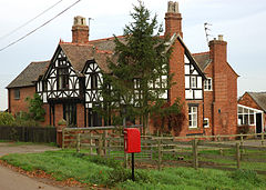
Ticknall is a small village and civil parish in South Derbyshire, England. The population of the civil parish at the 2011 Census was 642. Situated on the A514 road, close to Melbourne, it has three pubs, several small businesses, and a primary school. Two hundred years ago it was considerably larger and noisier with lime quarries, tramways and potteries. Coal was also dug close to the village. Close to the village is Calke Abbey, now a National Trust property.

Smisby is an ancient manor, civil parish and small village in South Derbyshire, England. It is 4 miles (6.4 km) from Melbourne and near the Leicestershire border and the town of Ashby-de-la-Zouch. The village including the outlying farms and houses has a population just over 200 that occupies some 110 properties. The population at the 2011 Census had increased to 260.
Scalford is a village and civil parish in the Melton borough of Leicestershire, England. It lies 4 miles (6.4 km) to the north of Melton Mowbray at the southern end of the Vale of Belvoir. In the 2011 census the parish had a population of 608.
North West Leicestershire District Council elections are held every four years. North West Leicestershire District Council is the local authority for the non-metropolitan district of North West Leicestershire in Leicestershire, England. Since the last boundary changes in 2015, 38 councillors are elected from 38 wards.

Little Stretton is a small village and civil parish in the Harborough district of Leicestershire that lies approximately 5.53 miles (8.90 km) southeast of the city of Leicester. The parish includes the deserted medieval village of Great Stretton (or Stretton Magna, a Scheduled Ancient Monument that is located 0.7 miles to the west of the village. The Gartree Road, a Roman Road, runs through the parish, adjacent to both Little and Great Stretton, and is the reason for those settlements' names. According to the University of Nottingham English Place-names project, the settlement name Stretton means "strēt" for a Roman road; and "tūn" for a settlement or an estate. The population of the civil parish at the 2011 census was 92, with approximately 36 households.

Shangton is a parish and village 1 mile (2 km) north of Tur Langton in Leicestershire, England. The parish is part of the Harborough district. According to the University of Nottingham English Place-names project, the settlement name Shangton could mean 'shank farm/settlement', a long, narrow bent piece of ground; a narrow ridge or 'shank' projecting from high ground beside the village. The population of the civil parish at the 2011 census was approximately 125.

Foston is a deserted medieval village and former civil parish, now in the parish of Kilby, in the Blaby district of Leicestershire and lies approximately 6.1 miles (9.8 km) south of the city of Leicester, England. The settlement name Foston means "Fotr's farm/settlement": "Fotr" is an Old Norse personal name, and "tūn" in Old English means an enclosure, farmstead, village or estate. In 1931 the parish of Foston had a population of 36. On 1 April 1935 the parish was abolished and merged with Kilby.

The Ticknall Tramway was a 12.8 mi (20.6 km) long 4 ft 2 in gauge horse-drawn plateway terminating at Ticknall, Derbyshire, England. It operated from 1802 to 1913.