Calvander, North Carolina

Last updated
Calvander, North Carolina
Calvandersign.JPG
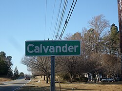
Entering from the south via Old NC 86
USA North Carolina location map.svg
Red pog.svg
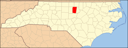
Location of Calvander in North Carolina
Usa edcp location map.svg
Red pog.svg
Calvander, North Carolina (the United States)
Coordinates: 35°56′35″N79°06′35″W / 35.94306°N 79.10972°W / 35.94306; -79.10972 Coordinates: 35°56′35″N79°06′35″W / 35.94306°N 79.10972°W / 35.94306; -79.10972
Country United States
State North Carolina
County Orange
Elevation
[1]
548 ft (167 m)
Time zone UTC-5 (Eastern (EST))
  Summer (DST) UTC-4 (EDT)
ZIP code
27516
Area code 919
GNIS feature ID982437 [1]

Calvander is a rural unincorporated community in southeastern Orange County, North Carolina, United States, located north-northwest of Carrboro. It lies at the intersection of Old Highway 86 and Homestead/Dairyland Road.

Calvander was named as a contraction of the name of Calvin Andrews, who founded the Andrews Academy, a 19th-century schoolhouse lying near the site of the current intersection. A map dated to 1891 identifies the community as including a saw mill, post office, and store. The crossroads currently houses a 76 gas station. [2]

Related Research Articles

<span class="mw-page-title-main">Alamance County, North Carolina</span> County in North Carolina, United States

Alamance County is a county in North Carolina. As of the 2020 census, the population was 171,415. Its county seat is Graham. Formed in 1849 from Orange County to the east, Alamance County has been the site of significant historical events, textile manufacturing, and agriculture.

<span class="mw-page-title-main">Seneca, South Carolina</span> City in South Carolina, United States

Seneca is a city in Oconee County, South Carolina, United States. The population was 8,102 at the 2010 census. It is the principal city of the Seneca Micropolitan Statistical Area, an (MSA) that includes all of Oconee County, and that is included within the greater Greenville-Spartanburg-Anderson, South Carolina Combined Statistical Area. Seneca was named for the nearby Cherokee town of Isunigu, which English colonists knew as "Seneca Town".

<span class="mw-page-title-main">Inman, South Carolina</span> City in South Carolina, United States

Inman is a city in Spartanburg County, South Carolina, United States. The population was 3,665 at the 2020 census, and 2,321 at the 2010 census.

<span class="mw-page-title-main">Mills River, North Carolina</span> Town in North Carolina, United States

Mills River is a town in Henderson County, North Carolina, United States. The population was 6,802 at the 2010 census, and was estimated to be 7,406 in 2019. The town took its name from the nearby confluence of the Mills River and French Broad River. It is part of the Asheville Metropolitan Statistical Area. It was incorporated into a town in June 2003. Sierra Nevada opened a brewery in Mills River in 2014.

Little Richmond is an unincorporated community located in the Marsh Township of Surry County, North Carolina.

Terrell is a community in Catawba County, North Carolina, United States. For the 2010 census, it was included within the Lake Norman of Catawba CDP.

Union Cross is an unincorporated community in the Dobson Township of central Surry County, North Carolina, United States. The community is roughly centered on the intersection of Dobbins Mill Road and Twin Oaks Road. Prominent landmarks include Union Cross Baptist Church, Union Cross Baptist Church cemetery, the Dockery Family Cemetery, and a local Ruritan club. The land for the Union Cross Ruritan Club was donated to the community for this purpose by Mrs. Minnie Shinault Dockery, widow of T. Alvin Dockery, a prominent local farmer and owner of the local general store. This Community is served by the Jot-Um-Down Volunteer Fire Department, which was founded in 1980. The Current Fire Chief is Ricky Holsclaw.

Oak Grove is an unincorporated community in northern Surry County, North Carolina, United States, located near Bottom.

<span class="mw-page-title-main">North Carolina Highway 157</span> State highway in North Carolina, US

North Carolina Highway 157 (NC 157) is a 29.3-mile-long (47.2 km) primary state highway in the U.S. state of North Carolina. The highway runs in a north–south direction from Interstate 85 (I-85), U.S. Route 15 (US 15), US 70, and US 501 in Durham, to US 158, US 501, and NC 57 in Roxboro. The highway serves the cities of Durham and Roxboro, along with the communities of Caldwell and Hurdle Mills. NC 157 is named Guess Road between its southern terminus and Hurdle Mills, and Hurdle Mills Road between Hurdle Mills and the Roxboro city limits. NC 157 does not directly parallel US 501, however, the two highways generally follow a similar alignment between Durham and Roxboro. NC 157 serves the counties of Durham, Orange, and Person.

Powhatan is an unincorporated community in Johnston County, North Carolina, United States, centered on the intersection of Powhatan Road and U.S. Route 70 Business, equidistant from the towns of Clayton and Wilson's Mills. It lies at an elevation of 302 feet.

Cleveland is an unincorporated community in suburban northwestern Johnston County, North Carolina, United States. It lies at an elevation of 243 feet (74 m). The settlement is also known as Cleveland Crossings, Cleveland Community, Cleveland School or 40/42, so named for the intersection of I-40 and NC 42 at the northeastern edge of the community, which serves as the primary commercial hub of the area. NC 50 skirts the western edge of the community. The community's population is concentrated along Cleveland Road in Johnston County. While officially unincorporated, postal addresses for the community generally lie in Garner, Clayton and Benson. The community is named for the Cleveland School, a former K-12 school lying on Cleveland Road, the grounds of which currently house a community center, senior adult housing, a gymnasium and numerous athletic fields managed by the Greater Cleveland Athletic Association (GCAA), and a branch of the Johnston Community College. Nearby unincorporated communities include McGee's Crossroads to the south along NC 50 and Willow Spring to the west along NC 42.

<span class="mw-page-title-main">Falls, North Carolina</span> Unincorporated community in North Carolina, United States

Falls, is an unincorporated community in Wake County, North Carolina, United States, situated on Old Falls of Neuse Road, between Raleigh and Wake Forest, near the Wakefield Plantation development. Falls Dam, on the Neuse River, is within the community.

Forestville is a formerly unincorporated community in Wake County, North Carolina, United States, east of Falls at an elevation of 390 feet or 119 m. It currently lies within the town of Wake Forest, south of the intersection of NC 98 and US 1 Alternate.

McCullers Crossroads is an unincorporated community in southern Wake County, North Carolina, United States, located midway between Raleigh and Fuquay Varina. It lies at the intersection of US 401 and SR 1010. Wake Technical Community College has its main campus nearby.

<span class="mw-page-title-main">Marble, North Carolina</span> Census-designated place in North Carolina, United States

Marble is an unincorporated community and census-designated place (CDP) in Cherokee County, North Carolina, United States. As of the 2010 census it had a population of 321.

<span class="mw-page-title-main">Hesters Store, North Carolina</span> Unincorporated community in North Carolina, United States

Hesters Store is an unincorporated community in Person County, North Carolina, United States. It lies at the intersection of Gordonton Road(State Road 1102) with Hesters Store Road and Wilson Road. The community derives its name from a country store that stood near the intersection for more than a century. In 1994, the most recent country store structure was converted into a fire station, the Hesters Store station of the Hurdle Mills Volunteer Fire Department.

Holly Springs is an unincorporated community located in the Mount Airy Township of Surry County, North Carolina, United States. The community is generally centered on the intersection of Holly Springs Road and Reeves Mill Road, southeast of Bannertown. The Mount Airy/Surry County Airport is located in Holly Springs. Other prominent landmarks include Holly Springs Baptist Church and a Bannertown Volunteer Fire Department substation.

Cornatzer is an unincorporated community in Davie County, North Carolina, United States. It is located at the intersection Cornatzer Road (SR 1606/SR 1616) and Milling Road (SR 1600). The community is named after the Cornatzer family who resided in what was then Advance, NC and sold their farm to R.J. Reynolds Tobacco Company.

Longwood is an unincorporated community in Brunswick County, North Carolina, United States. The community is located on North Carolina Highway 904, 8.6 miles (13.8 km) north of Sunset Beach. Longwood has a post office with ZIP code 28452.

Devore is an unincorporated community in the southwest portion of Taylor Township, Owen County, in the U.S. state of Indiana. It lies just south of the intersection of County Road 1000 North and County Road 100 East, which is a community about ten miles north of the city of Spencer, the county seat of Owen County. Its elevation is 755 feet, and it is located at 39°25′47″N86°45′10″W. This community is also known as Mill Grove.

References

  1. 1 2 "Calvander, North Carolina". Geographic Names Information System . United States Geological Survey, United States Department of the Interior.. Retrieved on 2008-03-31.
  2. "Pickard Mill" (PDF). Trading Path Association. Retrieved December 24, 2022.