Canadensis, Pennsylvania

Last updated

Canadensis, Pennsylvania
Canadensis Pennsylvania from West.jpg
Canadensis, Pennsylvania
USA Pennsylvania location map.svg
Red pog.svg
Canadensis
Usa edcp location map.svg
Red pog.svg
Canadensis
Coordinates: 41°11′31″N75°15′05″W / 41.19194°N 75.25139°W / 41.19194; -75.25139
Country United States
State Pennsylvania
County Monroe
Township Barrett
Government
  Township SupervisorRalph Megliola
Elevation
994 ft (303 m)
Population
 (2000)
  Total2,164
  Density44/sq mi (17/km2)
Time zone UTC-5 (Eastern (EST))
  Summer (DST) UTC-4 (EDT)
ZIP Code
18325
Area code 570
GNIS feature ID1192235 [1]
Website Barrett Township

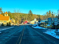
Canadensis is an unincorporated community in Barrett Township, Monroe County, Pennsylvania. Canadensis is home to a few small shops, restaurants and churches. The "crossroads", which is the intersection of Pennsylvania Routes 447 and 390, is the center of the community.

Contents

Pronunciation

Canadensis is pronounced Can-ah-DEN-sis.

Tourism

Business in Canadensis Candensis PA.jpg
Business in Canadensis

Canadensis is the "heart" of the Poconos; it is home to a number of bed and breakfasts. It is home to Spruce Lake Retreat. Spruce Lake hosts groups and also has an overnight camp and day-camp for kids. The area is more for the outdoor enthusiasts, mostly during the summer. In the summer Canadensis serves as a home to many sleepaway campers from the tri-state area at Camp Canadensis. [2] There are no actual tourism sites within Canadensis. Canadensis has a few restaurants and small businesses which function to serve the local economy rather than attract tourists.

Transportation

Canadensis has two state roads, Pennsylvania Route 447 and Pennsylvania Route 390, which intersect at the center of town. Its airport is the Flying Dollar Airport.

Bordering towns

Schools

Pocono Mountain School District (Bordering East Stroudsburg Area School District)

Bais Menachem YDP (Youth Development Program), a branch of the central Tomchei Tmimim Lubavitch moved to Canadensis in the Summer of 2018. Bais Menachem YDP is an all-male, ultra-orthodox, Chassidic, school for high school and college aged boys. Its core philosophies include Jewish and Chassidich principles, and ensuring that its students learn to become happy, healthy, respectful, and productive members of society at large. Bais Menachem YDP is an educational institution that besides for its standard educational pursuits does not stay bound to the rigid frameworks of some schools but encourages its students in their positive and healthy growth through music, art, self expression, and other creative forms. [3]

Government

Canadensis has no formal government; it is under the jurisdiction of the Barrett Township Supervisors.

Related Research Articles

<span class="mw-page-title-main">Pike County, Pennsylvania</span> County in Pennsylvania, United States

Pike County is a county in the Commonwealth of Pennsylvania. It is part of Northeastern Pennsylvania. As of the 2020 census, the population was 58,535. Its county seat is Milford.

<span class="mw-page-title-main">Monroe County, Pennsylvania</span> County in Pennsylvania, United States

Monroe County is a county in the Commonwealth of Pennsylvania. It is located in Northeastern Pennsylvania. As of the 2020 census, the population was 168,327. Its county seat is Stroudsburg. The county was formed from sections of Northampton and Pike counties on April 1, 1836.

<span class="mw-page-title-main">Barrett Township, Pennsylvania</span> Place in Pennsylvania, United States

Barrett Township is a township in Monroe County, Pennsylvania, United States. The population was 4,053 at the 2020 census. Two Poconos resort communities, Buck Hill Falls and Skytop, are located within the township. It is located 38 miles from Scranton and 48 miles from Wilkes-Barre. There is one privately owned, public-use airport in Barrett Township, called the Flying Dollar Airport.

<span class="mw-page-title-main">East Stroudsburg, Pennsylvania</span> Borough in Pennsylvania, United States

East Stroudsburg is a borough in Monroe County, Pennsylvania, and part of the Pocono Mountains region of the state. Originally known as Dansbury, East Stroudsburg was renamed for geographic reasons when the Delaware, Lackawanna, and Western Railroad opened a station in East Stroudsburg. Despite its name being derivative of its bordering borough, Stroudsburg, it has almost twice the population. East Stroudsburg is the largest municipality in Monroe County and in the East Stroudsburg, Pennsylvania, Metropolitan Statistical Area as designated by the Office of Management and Budget based on data from the 2010 US Census.

<span class="mw-page-title-main">Mount Pocono, Pennsylvania</span> Place in Pennsylvania, United States

Mount Pocono is a borough in Monroe County, Pennsylvania. It is located nearly centered in the southernmost county of five in the northeastern corner that are part of the Pocono Mountains. The borough serves as a local highway nexus, and sees a lot of tourist traffic making use of resources in the region. As of the 2020 census, the borough population was 3,083 residents.

<span class="mw-page-title-main">Tobyhanna Township, Pennsylvania</span> Place in Pennsylvania, United States

Tobyhanna Township is a township in Monroe County, Pennsylvania, United States. The population was 8,290 at the 2020 census. Tobyhanna Township has Tobyhanna Elementary Center and Locust Lake Village.

<span class="mw-page-title-main">Pocono Mountains</span> Geographic highland and cultural region in Pennsylvania, United States

The Pocono Mountains, commonly referred to as the Poconos, are a geographical, geological, and cultural region in Northeastern Pennsylvania. They overlook the Delaware River and Delaware Water Gap to the east, Lake Wallenpaupack to the north, Wyoming Valley and the Coal Region to the west, and the Lehigh Valley to the south. The name Pocono is derived from the Munsee word Pokawachne, which means "Creek Between Two Hills".

Skytop is an unincorporated community in Barrett Township, Monroe County, Pennsylvania, United States. Located north of Mountainhome, it is accessible by local roads off Route 390. Its elevation is 1,562 feet (476 m), and it is located at 41°13′40″N75°14′18″W. Although Skytop is unincorporated, it has a post office, with the ZIP code of 18357; the ZCTA for ZIP Code 18357 had a population of 87 at the 2000 census.

<span class="mw-page-title-main">Pennsylvania Route 940</span> State highway in Pennsylvania, US

Pennsylvania Route 940 is a 43.2-mile-long (69.5 km) Pennsylvania highway located in the Pocono Mountains. It runs from PA 309 in Hazleton east to PA 191 in Paradise Valley. Large segments of PA 940 are located in densely forested areas. The route heads northeast through Luzerne County from Hazleton, passing through Freeland and coming to an interchange with Interstate 80 (I-80) in White Haven. From here, PA 940 turns east and runs a short distance north of I-80, coming to an interchange with both I-80 and I-476 in northern Carbon County. The route continues through Monroe County and passes through Pocono Pines before it has an interchange with I-380. PA 940 passes through Mount Pocono prior to continuing to its eastern terminus.

<span class="mw-page-title-main">Pennsylvania Route 191</span> State highway in Pennsylvania, US

Pennsylvania Route 191 is a 111.54 mi (179.51 km)-long state highway in the U.S. state of Pennsylvania. The route, a major non-freeway corridor connecting the Lehigh Valley to the Pocono Mountains in eastern Pennsylvania, is designated from U.S. Route 22 in Brodhead near Bethlehem to the New York state line over the Delaware River at Hancock, New York.

<span class="mw-page-title-main">Pennsylvania Route 447</span> State highway in Pennsylvania, US

Pennsylvania Route 447 (PA 447) is a 26.66-mile-long (42.91 km) north–south state route located in northeast Pennsylvania in the Pocono Mountains. The southern terminus of the route is at U.S. Route 209 (US 209) near an interchange with Interstate 80 (I-80) in Smithfield Township. The northern terminus is at PA 191 and PA 507 in Dreher Township. The route heads northwest from US 209 in Monroe County and forms a brief concurrency with US 209 Business in the northern part of East Stroudsburg. PA 447 continues and forms a concurrency with PA 191 in Analomink before winding north through rural areas. The route bends northwest and crosses PA 390 in Canadensis. PA 447 passes through a section of Pike County before entering Wayne County and reaching its northern terminus.

Cresco is a village in Barrett Township, Monroe County in Northeastern Pennsylvania. Cresco is located in the Pocono Mountains. The ZIP Code is 18326. Area Code 570, Exchange: 595.

<span class="mw-page-title-main">Buck Hill Falls, Pennsylvania</span> Community in Pennsylvania, US

Buck Hill Falls is a private resort community in the Pocono Mountains of Northeastern Pennsylvania.

<span class="mw-page-title-main">Pennsylvania Route 196</span> State highway in Pennsylvania, US

Pennsylvania Route 196 is a state highway in the Pocono Mountains of Pennsylvania with a length of 25.7 miles (41.4 km). It runs from PA 611 and PA 940 in Mount Pocono in Monroe County north to PA 296 in Varden in Wayne County. The route is a two-lane undivided road that runs through rural areas. PA 196 intersects PA 423 near Tobyhanna State Park before entering Wayne County, where it crosses PA 507 in Angels and passes through Sterling. The route forms a concurrency with PA 191 and has a junction with PA 590 in Hamlin. Upon splitting from PA 191, PA 196 continues north to its end at PA 296.

<span class="mw-page-title-main">Pennsylvania Route 390</span> State highway in Monroe and Pike counties in Pennsylvania, United States

Pennsylvania Route 390 is a 25.3-mile-long (40.7 km) state highway located in Monroe and Pike counties in Pennsylvania. The southern terminus is at PA 940 in Paradise Township. The northern terminus is at PA 507 in Tafton View. The route is a two-lane undivided road that runs through forested areas in the Pocono Mountains. PA 390 begins at PA 940 west of Paradise Valley and heads northeast. The route runs concurrent with PA 191 between Cresco and Mountainhome before it splits and intersects PA 447 in Canadensis. PA 390 passes through Skytop before it crosses the county line and runs through Promised Land State Park. The route has an interchange with Interstate 84 (I-84) before passing through Tafton and ending at PA 507 near Lake Wallenpaupack.

<span class="mw-page-title-main">Pennsylvania Route 507</span> State highway in Pennsylvania, US

Pennsylvania Route 507 is a 27.2-mile-long (43.8 km) state highway located in Monroe, Wayne, and Pike counties in Pennsylvania. The southern terminus is at PA 435 and at an interchange with Interstate 380 (I-380) near Gouldsboro. The northern terminus is at U.S. Route 6 in Palmyra Township. PA 507 runs southwest-northeast as a two-lane undivided through forests in the upper reaches of the Pocono Mountains, with the northern section nearly parallel to Lake Wallenpaupack. The route passes through Gouldsboro before it crosses PA 196 in Angels. In Newfoundland, PA 507 and PA 191 run concurrent for about 2 miles (3.2 km) and intersect the north end of PA 447. After splitting from PA 191, the route has an interchange with I-84 and a junction with the northern terminus of PA 390 before ending at US 6. PA 507 was designated between US 611 west of Gouldsboro and US 6 in Tafton in 1928. The route was fully paved by the 1930s and has remained on the same alignment since.

Tafton is an unincorporated community in Pike County, Pennsylvania, United States. The major routes in Tafton are PA 507 and PA 390. Tafton borders Lake Wallenpaupack to the west and Blooming Grove to the east. There is a lake that hugs PA 390 called Fairview Lake, which is located in Tafton. Fairview Lake is home to an all-girls summer camp called Camp Oneka. The now-closed Tanglewood Ski Area and Winter Park is also located in Tafton.

<span class="mw-page-title-main">Camp Canadensis</span> Jewish camp, USA

Camp Canadensis is a seven-week, co-ed, overnight Jewish camp located in the Pocono Mountains region of Monroe County, Pennsylvania, US. Camp Canadensis is made up of campers primarily from New York, New Jersey, and Pennsylvania; however, there are campers coming from other nearby states. Facilities include a 75-acre (300,000 m2) private lake, indoor and outdoor hockey rinks, a 2,500-square-foot (230 m2) gymnastics room, indoor, and outdoor basketball courts, two heated pools, a 9,000-square-foot (840 m2) art center, a high ropes adventure course, a low ropes team building circuit, a 40-foot (12 m) high rock wall, horse stables, a golf range, an all-weather outdoor amphitheater, and 16 tennis courts, 12 of which are lit for night use.

<span class="mw-page-title-main">Pocono Summit, Pennsylvania</span> Census-designated place in Pennsylvania, United States

Pocono Summit is an unincorporated community and census-designated place that is located in Monroe County, Pennsylvania. Parts of Pocono Summit are located in the municipalities of Coolbaugh and Tobyhanna townships.

<span class="mw-page-title-main">Flying Dollar Airport</span> Airport in Monroe County

Flying Dollar Airport is a privately owned, public-use airport located two nautical miles north of the central business district of Canadensis in Barrett Township, Monroe County, Pennsylvania, United States.

References

  1. "Canadensis". Geographic Names Information System . United States Geological Survey, United States Department of the Interior.
  2. "Home". canadensis.com.
  3. BaisMenachem.com