Canley Vale High School

Last updated

Canley Vale High School
Canley Vale High School Logo.jpg
School Gates.jpg
The school's main entrance (2015)
Location
Canley Vale High School

Australia
Coordinates 33°53′6″S150°57′5″E / 33.88500°S 150.95139°E / -33.88500; 150.95139
Information
Type Government-funded co-educational comprehensive secondary day school
MottoWe Care
Established1965;59 years ago (1965)
Educational authority New South Wales Department of Education
PrincipalEffie Niarchos [1]
Years 712
Enrolment~1,400 [2]  (2012)
Campus type Suburban
Colour(s)Navy Blue and White   
Website canleyvale-h.schools.nsw.gov.au
CVHS Front Gate Sign.jpg
School signs at the main gate of the campus, c.2016
Canley Vale High School

Canley Vale High School (abbreviated as CVHS) is a government-funded co-educational comprehensive secondary day school, located in Canley Vale, a south-western suburb of Sydney, New South Wales, Australia.

Contents

Established in 1965 in an area that once comprised orchards, the school now caters for approximately 1,500 students from Year 7 to Year 12. The school is operated by the New South Wales Department of Education.

Campus

The school is situated in Canley Vale, a suburb in south-western Sydney (adjacent to Cabramatta).

The campus is built around the main quadrangle, next to the Historic bell tower. As of 2015, the school's foundation bell (originally housed in an actual tower) was restored and positioned on a metal frame over the base remnants of the bell tower, below where it would've been positioned had the tower remained.

The bell was restored in time for school's 50th Anniversary, but for some bizarre reason was then stolen a few weeks later. [3] Fortunately enough the bell was eventually recovered by police a few weeks after the incident, having been left discarded by presumably thieves in a creek.

Other facilities includes a renovated multi-purpose school hall on the western end of the school, a double-storey library, an administrative facility, a canteen, computer labs, a lecture theatre (a single hall amphitheatre) at the school's eastern end, a Timber Trades Centre (TTC), a newly built 'Learning Hub' centre, and a school gym (located in the place of the school's table tennis complex) near the quadrangle at the heart of the school. To the front and south of the school's 'Bell Tower' Quadrangle is the school's assembly area which is approx. the size of 2 basketball courts. Opposite to this and north of the quadrangle is a sail-covered turf area for students with 3 basketball courts located in its north-eastern direction.

Orphan School Creek which flows behind the school, and Ada Street Reserve (a federally protected nature reserve to the school's northeast) marks the school's natural boundaries. The school runs relatively adjacent Prospect Road, Canley Vale, with its Eastern boundaries marked by Ada Street. Further north of Ada Street Reserve is Sherwin Park, which is utilised by the school during school hours (in addition to the nearby Parkes Reserve) for sports.

The school is located about 10–15 minutes away from both Canley Vale railway station and Carramar railway station.

Student life

Canley Vale High attracts many students from outside the local area and overseas due to its multicultural environment and student welfare program. [4] A high proportion of the school's student population comes from a non-English speaking background, which includes predominately those of Cambodian, Chinese and Vietnamese heritage as well as students with Polynesian backgrounds.[ citation needed ]

Academic results

Canley Vale High School has close ties with the local community and has a reputation for high academic achievement and expectations of student excellence; [5] and is one of the best academically non-selective co-educational public high schools in the Liverpool–Fairfield area. [6] [ failed verification ] In 2016, the school was the highest ranked in Higher School Certificate results for New South Wales schools with the lowest levels of socio-educational advantage. [7]

Houses

As with most Australian schools, CVHS utilises a house system. Students are allocated to a house when they enter the school according to the first letter of their surname. The four school houses are further represented through their individual 'house banners' which (in addition to the school banner) is kept in permanent overhanging display in the school's hall. There are four different houses under which students compete for the swimming, athletics and cross country carnivals:

House nameColourNamingNotes
Bonham  RedHard to pinpoint as the origins aren't definite. A likely contender is Bonham Street, Canley Vale, which is located East of the school, branching off Ada St and allows direct access to Parkes Reserve.
Horsley  Yellow The Horsley Drive, itself drawn from the Horsley complex in Surrey, England [8]
Lennox  Green David Lennox, [9] a convict-era architect who designed and oversaw the construction of the nearby Lansdowne Bridge. Lennox also designed and oversaw the creation of the Lennox Bridge, Glenbrook and Lennox Bridge, Parramatta.
Parkes  BlueParkes Reserve, located near the school; likely to be drawn from Henry Parkes (Australia's 'Father of Federation' & named the suburb of Canley Vale after his birthplace of Canley, UK)

Notable alumni

Campus Photos

See also

Related Research Articles

<span class="mw-page-title-main">Pewsey</span> Village and civil parish in Wiltshire, England

Pewsey is a large village and civil parish at the centre of the Vale of Pewsey in Wiltshire, about 6 miles (10 km) south of Marlborough and 71 miles (114 km) west of London. It is within reach of the M4 motorway and the A303 and is served by Pewsey railway station on the Reading to Taunton line.
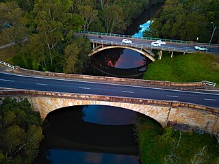
<span class="mw-page-title-main">Victoria Park, Sydney</span> Historic site

Victoria Park is a 9-hectare (22-acre) urban park situated on the corner of Parramatta Road and City Road, Camperdown, in the City of Sydney, New South Wales, Australia. The park is located adjacent to The University of Sydney and the Broadway Shopping Centre.

<span class="mw-page-title-main">James Ruse Agricultural High School</span> School in Australia

James Ruse Agricultural High School is a government-funded co-educational academically selective and specialist secondary day school, located in the Sydney suburb of Carlingford, New South Wales, Australia, long known for being the highest academically ranked high school in Australia. The school is also one of four New South Wales Government agricultural high schools.

<span class="mw-page-title-main">St John's College (Johannesburg)</span> Private & boarding school in Johannesburg, Gauteng, South Africa

St John's College is a private Anglican day and boarding school situated in Houghton Estate in the city of Johannesburg in the Gauteng province of South Africa. It was founded in 1898 and comprises five schools: College, Preparatory, Pre-Preparatory and The Bridge Nursery, as well as a co-educational Sixth Form. St John's College is a member of the ISASA.

<span class="mw-page-title-main">Mittagong</span> Town in New South Wales, Australia

Mittagong is a town located in the Southern Highlands of New South Wales, Australia, in Wingecarribee Shire. The town acts as the gateway to the Southern Highlands when coming from Sydney. Mittagong is situated at an elevation of 635 metres (2,083 ft). The town is close to Bowral, Berrima, Moss Vale and the Northern Villages such as Yerrinbool and Colo Vale. Moreover, Mittagong is home to many wineries of the Southern Highlands which has been a recent growing wine and cellar door region.

<span class="mw-page-title-main">Baulkham Hills High School</span> School in Australia

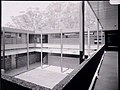
Baulkham Hills High School is a government-funded academically selective co-educational secondary day school. It is located in Baulkham Hills in the Hills District of Sydney, New South Wales, Australia.

<span class="mw-page-title-main">Canley Vale, New South Wales</span> Suburb of Sydney, New South Wales, Australia

Canley Vale is a suburb of Sydney, in the state of New South Wales, Australia. Canley Vale is located 30 kilometres west of the Sydney central business district, in the local government area of the City of Fairfield and is part of the South Western Sydney region.

Canley Heights is a suburb of Sydney, in the state of New South Wales, Australia 31 kilometres west of the Sydney central business district, in the local government area of the City of Fairfield and is part of the South-western Sydney region.

Fairfield West is a suburb of Sydney, in the state of New South Wales, Australia. Fairfield West is located 27 kilometres west of the Sydney central business district in the local government area of the City of Fairfield. Fairfield West is part of the Greater Western Sydney region.

<span class="mw-page-title-main">Bayview, New South Wales</span> Suburb of Sydney, New South Wales, Australia

Bayview is a suburb in Sydney's Northern Beaches region, in the state of New South Wales, Australia 31 kilometres north of the Sydney central business district, in the local government area of Northern Beaches Council.

<span class="mw-page-title-main">Penrith Selective High School</span> School in Australia

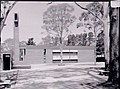
Penrith Selective High School (PSHS) is a public co-educational academically selective secondary day school, located in Penrith, in Western Sydney, New South Wales, Australia. Established in 1950 and operated by the NSW Department of Education, the school caters for approximately 925 students from Year 7 to Year 12.

<span class="mw-page-title-main">Fairvale High School</span> School in Australia

Fairvale High School is a government-funded co-educational comprehensive secondary day school, located in Fairfield West, a south-western suburb of Sydney, New South Wales, Australia.

CVHS may refer to:

<span class="mw-page-title-main">Barry Dock Offices</span> Council building in Barry, Vale of Glamorgan, Wales, United Kingdom

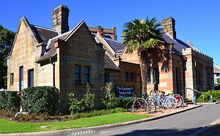
Barry Docks Offices is a council building in Barry, Vale of Glamorgan in south-east Wales. It is prominently sited, overlooking the docks to the south, below the town and on a level site near Castleland Point, a promontory within Dock View Road. Barry Docks railway station is adjacent to the building and to its rear.

<span class="mw-page-title-main">University of Otago Clocktower complex</span>

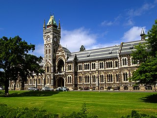
The University of Otago Clocktower complex is a group of architecturally and historically significant buildings in the centre of the University of Otago campus. Founded in Dunedin, New Zealand, in 1869, the University of Otago was the expression of the province's Scottish founders' commitment to higher education. They were also the inheritors of a strong architectural tradition and gritty determination. Defending the decision to build inexpensive materials in an elaborate historicizing manner the Chancellor, Dr. D.M. Stuart, said "the Council had some old-world notions and liked to have a university with some architectural style". This attitude persisted for over fifty years and resulted in an impressive group of buildings.

<span class="mw-page-title-main">Kingsgrove North High School</span> School in Kingsgrove, New South Wales, Australia

Kingsgrove North High School is a co-educational public high school located in Kingsgrove, New South Wales, Australia and founded in 1959. The school is part of the St. George Region of high schools and is administered by the New South Wales Department of Education.

Kotara High School is a government-funded co-educational comprehensive secondary day school, located in Adamstown Heights, a suburb of Newcastle, New South Wales, Australia.

<span class="mw-page-title-main">Jacaranda, University of Sydney</span> Historic tree at the University of Sydney

The jacaranda was a historically significant specimen of Jacaranda mimosifolia tree that stood in the south-eastern corner of the University of Sydney main quadrangle, and now describes its clone replanted in the same location.

<span class="mw-page-title-main">St Francis Xavier's Roman Catholic Church, Berrima</span> Church in New South Wales, Australia

St Francis Xavier's Roman Catholic Church is a heritage-listed Catholic church at Hume Highway, Berrima, Wingecarribee Shire, New South Wales, Australia. It was designed by Augustus Pugin and built from 1849 to 1851 by William Munro. Originally known as St. Scholastica's Church, it is used by the Parish of St. Paul, administered by the Pauline Fathers, and located in the Diocese of Wollongong. It was added to the New South Wales State Heritage Register on 25 January 2008.

<span class="mw-page-title-main">Lennox River</span> River in New South Wales, Australia

The Lennox River is the proposed name for a waterway located in Sydney's South-Western Suburbs. The existing waterway is the tidal reach of Prospect Creek, a tributary of the Georges River. A proposal has been made to upgrade and reclassify the waterway as a 'river'. The proposed river would be 6.5 kilometres (4 mi) long, starting at the confluence of Orphan School Creek and Prospect Creek at Fairfield and flowing to the Georges River emptying into Dhurawal Bay at Garrison Point.

References

  1. "Our Staff". Canley Vale High School. Retrieved 30 January 2023.
  2. "Canley Vale High School". Archived from the original on 5 January 2017. Retrieved 4 January 2017.
  3. "Bring back our old bell: Canley Vale High School School plea". 8 September 2015.
  4. "Department of Education-School Profile". Archived from the original on 5 January 2017. Retrieved 4 January 2017.
  5. "DET - CVHS Overview". Archived from the original on 5 January 2017. Retrieved 4 January 2017.
  6. "Canley Vale HS Achievements" . Retrieved 5 March 2011.
  7. Munro, Kelsey; Ting, Inga (16 December 2016). "HSC results 2016: The schools punching above their weight". The Sydney Morning Herald . Retrieved 4 July 2019.
  8. The Heritage of Australia, Macmillan Company, 1981, p.2/24
  9. Antill, J. M. "Lennox, David (1788–1873)". Australian Dictionary of Biography . National Centre of Biography, Australian National University. ISSN   1833-7538 . Retrieved 10 October 2017.
  10. "Maria Tran". IMDb. Retrieved 18 April 2016.