Capranica Prenestina | ||
---|---|---|
Comune | ||
Comune di Capranica Prenestina | ||
| ||
Coordinates: 41°52′N12°57′E / 41.867°N 12.950°E | ||
Country | Italy | |
Region | Lazio | |
Metropolitan city | Rome (RM) | |
Frazioni | Guadagnolo | |
Government | ||
• Mayor | Francesco Colagrossi | |
Area | ||
• Total | 20.36 km2 (7.86 sq mi) | |
Elevation | 915 m (3,002 ft) | |
Population (31 May 2017) [1] | ||
• Total | 343 | |
• Density | 17/km2 (44/sq mi) | |
Demonym(s) | Capranicensi | |
Time zone | UTC+1 (CET) | |
• Summer (DST) | UTC+2 (CEST) | |
Postal code | 00030 | |
Dialing code | 06 | |
Patron saint | St. Roch | |
Saint day | August 16 | |
Website | Official website |
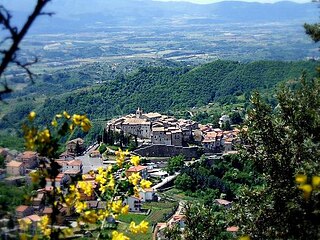
Capranica Prenestina is a comune (municipality) in the Metropolitan City of Rome in the Italian region Lazio, located about 40 kilometres (25 mi) east of Rome.
The comune is a basic administrative division in Italy, roughly equivalent to a township or municipality.
Italy, officially the Italian Republic, is a country in Southern and Western Europe. Located in the middle of the Mediterranean Sea, Italy shares open land borders with France, Switzerland, Austria, Slovenia and the enclaved microstates San Marino and Vatican City. Italy covers an area of 301,340 km2 (116,350 sq mi) and has a largely temperate seasonal and Mediterranean climate. With around 61 million inhabitants, it is the fourth-most populous EU member state and the most populous country in Southern Europe.
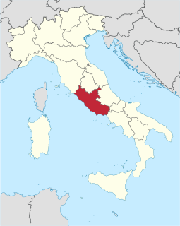
Lazio is one of the 20 administrative regions of Italy. Situated in the central peninsular section of the country, it has almost 5.9 million inhabitants – making it the second most populated region of Italy – and its GDP of more than 170 billion euros per annum means that it has the nation's second largest regional economy. The capital of Lazio is Rome, which is also Italy's capital and the country's largest city.
It is located in the Monti Prenestini area.
Canterano is a comune (municipality) in the Metropolitan City of Rome in the Italian region Latium, located about 45 kilometres (28 mi) east of Rome.
Carpineto Romano is a comune (municipality) in the Metropolitan City of Rome in the Italian region Lazio, located about 60 kilometres southeast of Rome.
Castelnuovo di Porto is a comune (municipality) in the Metropolitan City of Rome in the Italian region Latium, located about 25 kilometres (16 mi) north of Rome.
Castel San Pietro Romano is a comune (municipality) in the Metropolitan City of Rome in the Italian region Latium, located about 35 kilometres (22 mi) east of Rome.
Cerreto Laziale is a comune (municipality) in the Metropolitan City of Rome in the Italian region Latium, located about 40 kilometres (25 mi) east of Rome.
Civitella San Paolo is a comune (municipality) in the Metropolitan City of Rome in the Italian region of Lazio, located about 35 kilometres (22 mi) north of Rome.
Filacciano is a comune (municipality) in the Metropolitan City of Rome in the Italian region Latium, located about 40 kilometres (25 mi) north of Rome.
Gerano is a comune (municipality) in the Metropolitan City of Rome in the Italian region Latium, located about 40 kilometres east of Rome.
Marano Equo is a comune (municipality) in the Metropolitan City of Rome in the Italian region Latium, located about 45 kilometres (28 mi) east of Rome. It stands on a steep slope descending to the Aniene valley with the Monti Simbruini located nearby.
Marcellina is a comune (municipality) in the Metropolitan City of Rome in the Italian region Latium, located about 30 kilometres (19 mi) northeast of Rome.
Morlupo is a comune (municipality) in the Metropolitan City of Rome in the Italian region Latium, located about 30 kilometres (19 mi) north of Rome.
Nazzano is a comune (municipality) in the Metropolitan City of Rome in the Italian region Lazio, located about 40 kilometres (25 mi) north of Rome.
Percile is a comune (municipality) in the Metropolitan City of Rome in the Italian region Latium, located about 40 kilometres (25 mi) northeast of Rome.
Pisoniano is a comune (municipality) in the Metropolitan City of Rome in the Italian region Lazio, located about 40 kilometres (25 mi) east of Rome.
Riano is a comune (municipality) in the Metropolitan City of Rome in the Italian region Latium. It is located about 20 kilometres (12 mi) north of Rome, in the Tiber River valley, not far from Veio.
Roccagiovine is a comune (municipality) in the Metropolitan City of Rome in the Italian region Latium, located about 35 kilometres (22 mi) northeast of Rome. It is included in the Natural Park of the Monti Lucretili.
Roiate is a comune (municipality) in the Metropolitan City of Rome in the Italian region Latium, located on the slope of Monte Scalambra on the hills between the Sacco and Aniene Rivers, about 45 kilometres (28 mi) east of Rome.
Sambuci is a comune (municipality) in the Metropolitan City of Rome in the Italian region Latium, located about 35 kilometres (22 mi) east of Rome.
Vallinfreda is a comune (municipality) in the Metropolitan City of Rome in the Italian region Lazio, located approximately 45 kilometres (28 mi) northeast of Rome.
Fonte Nuova is a comune (municipality) in the Metropolitan City of Rome in the Italian region Lazio, located about 15 kilometres (9 mi) northeast of Rome.
This Lazio location article is a stub. You can help Wikipedia by expanding it. |