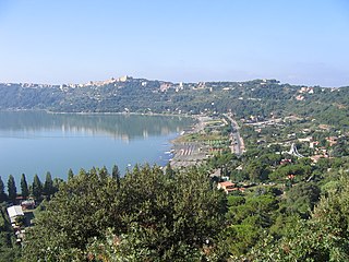
Castel Gandolfo, colloquially known as Castello in the Castelli Romani dialects, is a town located 25 km (16 mi) southeast of Rome, in the Italian region of Lazio. Situated on a hilltop in the Alban Hills with panoramic views of Lake Albano, Castel Gandolfo is home to approximately 8,900 residents and is renowned as one of Italy's most scenic towns. It is one of I Borghi più belli d'Italia.

Cocullo is a comune and town in the Province of L'Aquila, located in the Abruzzo region of Italy. As of 2013 its population was of 246.

Castel Viscardo is a comune (municipality) in the Province of Terni in the Italian region Umbria,
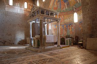
Castel Sant'Elia is a comune (municipality) in the Province of Viterbo, Latium, central Italy, located about 40 kilometres (25 mi) north of Rome and about 30 kilometres (19 mi) southeast of Viterbo.

Faleria is a comune (municipality) in the Province of Viterbo in the Italian region of Latium, located about 35 kilometres (22 mi) north of Rome and about 35 kilometres (22 mi) southeast of Viterbo.
Onano is a comune (municipality) in the Province of Viterbo in the Italian region Lazio, located about 100 kilometres (62 mi) northwest of Rome and about 40 kilometres (25 mi) northwest of Viterbo.

Ascrea is a comune (municipality) in the Province of Rieti in the Italian region of Latium, located about 50 kilometres (31 mi) northeast of Rome and about 25 kilometres (16 mi) southeast of Rieti.

Borgo Velino is a comune (municipality) in the Province of Rieti in the region of Latium, Italy. It is located about 70 kilometres (43 mi) northeast of Rome and about 15 kilometres (9 mi) east of the town Rieti. It has an area of 17.3 square kilometres (6.7 sq mi), and as of 31 December 2010 it had a population of 1,004. Until 1927 Borgo Velino was part of the province of L'Aquila in Abruzzo. It is located near the site of a pre- or early-Roman Sabine village named Viario. Rare ruins of this ancient village, now occupied by a cultivated field, were found near a standing medieval tower. Borgo Velino is the birthplace of Giulio Pezzola, a notorious outlaw of the 17th century.

Castel di Tora is a comune (municipality) in the Province of Rieti in the Italian region of Lazio, located about 50 kilometres (31 mi) northeast of Rome and about 20 kilometres (12 mi) southeast of Rieti.

Castel Sant'Angelo is a comune (municipality) in the Province of Rieti in the Italian region of Lazio, located about 70 kilometres (43 mi) northeast of Rome and about 12 kilometres (7 mi) east of Rieti.

Colle di Tora is a comune (municipality) in the Province of Rieti in the Italian region of Latium, located about 50 kilometres (31 mi) northeast of Rome and about 20 kilometres (12 mi) southeast of Rieti. It is located on the shores of Lake Turano.

Micigliano is a comune (municipality) in the Province of Rieti found in the Italian region of Latium. It is located in about 80 kilometres (50 mi) northeast of Rome and about 15 kilometres (9 mi) northeast of Rieti. As of 31 December 2004, it had a population of 146 people and an area of 37.8 square kilometres (14.6 sq mi).

Poggio Mirteto is a comune (municipality) is situated in the Tiber Valley area of the region of Latium, Italy. Administratively Poggio Mirteto is in the province of Rieti and geographically this municipality is about 45 kilometres (28 mi) northeast of Rome and about 20 kilometres (12 mi) southwest of Rieti.

Varco Sabino is a comune (municipality) in the Province of Rieti in the Italian region of Latium, located about 60 kilometres northeast of Rome and about 20 kilometres (12 mi) southeast of Rieti.

Castel San Pietro Romano is a comune (municipality) in the Metropolitan City of Rome in the Italian region of Latium, located about 35 kilometres (22 mi) east of Rome. In 2017, it had a population of 883.
Ciciliano is a comune (municipality) in the Metropolitan City of Rome in the Italian region of Latium, located about 35 kilometres (22 mi) east of Rome.

Mazzano Romano is a comune (municipality) in the Metropolitan City of Rome in the Italian region of Latium, located about 35 kilometres (22 mi) north of Rome.

San Gregorio da Sassola is a comune (municipality) in the Metropolitan City of Rome in the Italian region of Latium, located about 30 kilometres (19 mi) east of Rome.
La Roda de Andalucía is a municipality of the Province of Seville, Andalusia, Spain. In 2005 it had a population of 4,322 inhabitants and an area of 320 square kilometres (124 sq mi). The density is 56.1 ihhab/km2. It is located at an altitude of 405 metres (1,329 ft) and is 123 kilometres from Seville (city).
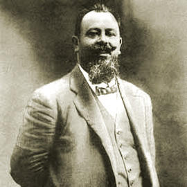
Giovanni Montemartini was an Italian economist and politician.