Related Research Articles

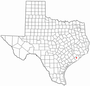
Brazoria County is a county in the U.S. state of Texas. As of the 2020 census, the population of the county was 372,031. The county seat is Angleton.

Matagorda County is a county located in the U.S. state of Texas. As of the 2020 census, its population was 36,255. Its county seat is Bay City, not to be confused with the larger Baytown in Harris and Chambers Counties. Matagorda County is named for the canebrakes that once grew along the coast.

Mayes County is a county located in the U.S. state of Oklahoma. As of the 2020 census, the population was 39,046. Its county seat is Pryor Creek. Named for Samuel Houston Mayes, Principal Chief of the Cherokee Nation from 1895 to 1899, it was originally created at the Sequoyah Convention in August 1905.

Damon is a census-designated place (CDP) in Brazoria County, Texas, United States. The population was 436 at the 2020 census. The town is located about 20 miles (32 km) south of Rosenberg on Texas State Highway 36. Damon sits partly atop a salt dome which was exploited for petroleum, sulphur, and limestone.

Freeport is a city in Brazoria County, Texas, United States, located on the Gulf of Mexico. According to the 2020 census, the city population was 10,696, down from 12,049 in 2010.
Holiday Lakes is a town in Brazoria County, Texas, United States. The population was 991 at the 2020 census.

Jones Creek is a village in Brazoria County, Texas, United States. The population was 1,975 at the 2020 census. It is the first location in Texas where Stephen F. Austin settled.

Manvel is a city in Brazoria County, Texas, United States. As of July 2022, the population was 14,803, up from 9,908 at the 2020 census.

For the river in Fort Bend and Brazoria Counties, Texas see: Oyster Creek (Texas).

Richwood is a city in Brazoria County, Texas, United States. The population was 4,781 at the 2020 census.

The Caloosahatchee River is a river on the southwest Gulf Coast of Florida in the United States, approximately 67 miles (108 km) long. It drains rural areas on the northern edge of the Everglades, east of Fort Myers. An important link in the Okeechobee Waterway, a manmade inland waterway system of southern Florida, the river forms a tidal estuary along most of its course and has become the subject of efforts to restore and preserve the Everglades.

The San Bernard River is a river in Texas.

Area code 979 is a telephone area code in the North American Numbering Plan (NANP) for the U.S. state of Texas. The numbering plan area comprises the region generally following the Brazos River found between the Austin and Houston metro areas and its surrounding communities, stretching from just south of Waco to the Gulf Coast. It was created on February 13, 2000, in a split from area code 409.

The San Bernard National Wildlife Refuge is a 45,730-acre (185.1 km2) wildlife conservation area along the coast of Texas (USA), south of the towns of Sweeny and Brazoria, Texas. It encloses a bay behind a barrier island at the Gulf of Mexico. The refuge is located in southern Brazoria and eastern Matagorda counties.
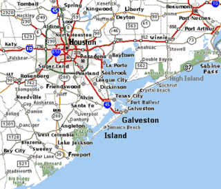
The Brazoria National Wildlife Refuge is a 44,414-acre (179.74 km2) wildlife conservation area along the coast of Texas (USA), east of the towns of Angleton and Lake Jackson, Texas. It borders Christmas Bay and the Intracoastal Waterway, separated from the Gulf of Mexico by Follet's Island.

Caney Creek (Matagorda Bay) is a river in Texas that begins northwest of Wharton, flows generally southeast, and empties into the Gulf of Mexico near Sargent. The major waterway to the west is the Colorado River while the next major waterway to the east is the San Bernard River.

For the community in Brazoria County, Texas see: Oyster Creek, Texas.

Clear Creek is a small river in Southeast Texas in the United States, which channels much of the run-off in southeast Harris County into Clear Lake and Galveston Bay. Much of the length of the stream forms the boundary between Harris County and Galveston County and all of the boundary with Brazoria County. It originates in the Blue Ridge Oilfield in Fort Bend County.

The U.S. state of Texas has a series of estuaries along its coast on the Gulf of Mexico, most of them bounded by the Texas barrier islands. Estuaries are coastal bodies of water in which freshwater from rivers mixes with saltwater from the sea. Twenty-one drainage basins terminate along the Texas coastline, forming a chain of seven major and five minor estuaries: listed from southwest to northeast, these are the Rio Grande Estuary, Laguna Madre, the Nueces Estuary, the Mission–Aransas Estuary, the Guadalupe Estuary, the Colorado–Lavaca Estuary, East Matagorda Bay, the San Bernard River and Cedar Lakes Estuary, the Brazos River Estuary, Christmas Bay, the Trinity–San Jacinto Estuary, and the Sabine–Neches Estuary. Each estuary is named for its one or two chief contributing rivers, excepting Laguna Madre, East Matagorda Bay, and Christmas Bay, which have no major river sources. The estuaries are also sometimes referred to by the names of their respective primary or central water bodies, though each also includes smaller secondary bays, inlets, or other marginal water bodies.
References
- ↑ "Cedar Lake". Geographic Names Information System . United States Geological Survey, United States Department of the Interior . Retrieved December 4, 2024.
- ↑ "San Bernard River and Cedar Lakes Estuary | Minor Estuaries | Texas Water Development Board". www.twdb.texas.gov. Retrieved 2024-09-01.
- ↑ "Cedar Lake Creek at the San Bernard National Wildlife Refuge". Brazosport. Retrieved 2024-09-01.
- ↑ "Cedar Lake (Brazoria County)". Texas State Historical Association. Retrieved 2024-09-01.

29°11′33″N95°04′59″W / 29.19250°N 95.08306°W
 | This article about a location in Brazoria County, Texas is a stub. You can help Wikipedia by expanding it. |