
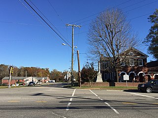
Saluda is a town in Saluda County, South Carolina, United States, along the Little Saluda River. The population was 3,565 at the 2010 census. It is the county seat of Saluda County.

Saluda is a city in Polk and Henderson counties in the U.S. state of North Carolina. The population was 713 at the 2010 census. Saluda is famous for sitting at the top of the Norfolk Southern Railway's Saluda Grade, which was the steepest main line standard-gauge railway line in the United States until Norfolk Southern ceased operations on the line in 2001. Saluda is close to the South Carolina state line, between Asheville, North Carolina, and Spartanburg, South Carolina.

Piedmont is a census-designated place (CDP) along the Saluda River in Anderson and Greenville counties in the U.S. state of South Carolina. The population was 5,103 at the 2010 census.
Saluda is a census-designated place (CDP) in and the county seat of Middlesex County, Virginia, United States. The population as of the 2010 Census was 769.

Celestia is a 3D astronomy program created by Chris Laurel. The program is based on the Hipparcos Catalogue (HIP) and allows users to virtually travel through an extensive universe, modeled after reality, at any speed, in any direction, and at any time in history. Celestia displays and interacts with objects ranging in scale from small spacecraft to entire galaxies in three dimensions using OpenGL, from perspectives which would not be possible from a classic planetarium or other ground-based display.

The Nation of Celestial Space is a micronation created by Evergreen Park, Illinois, resident James Thomas Mangan. Celestia comprised the entirety of "outer space", which Mangan laid claim to on behalf of humanity to ensure that no one country might establish a political hegemony there. As "Founder and First Representative", he registered this acquisition with the Recorder of Deeds and Titles of Cook County on January 1, 1949. At its foundation Celestia claimed to have 19 members, among them Mangan's daughter Ruth; a decade later a booklet published by the group claimed that membership had grown to 19,057.
Lake Murray Country is a large area of South Carolina, United States; the region includes the counties of Newberry, Saluda, Lexington, and Richland.

Lake Murray is a reservoir in the U.S. state of South Carolina. It is approximately 50,000 acres (200 km2) in size, and has roughly 500 miles (800 km) of shoreline. It was impounded in the late 1920s to provide hydroelectric power to the state of South Carolina. Lake Murray is fed by the Saluda River, which flows from upstate South Carolina near the North Carolina state line. The Saluda Dam was an engineering feat at the time of its construction. The dam, using the native red clay soil and bedrock, was the largest earthen dam in the world when it was completed in 1930. Lake Murray itself is named after the project's chief engineer, William S. Murray. The Saluda Dam is approximately 1.5 miles (2.4 km) long and 220 feet (67 m) high. Lake Murray is 41 miles (66 km) long, and 14 miles (23 km) wide at its widest point. At the time when the lake was finished, it was the world's largest man-made reservoir.

The Saluda River is a principal tributary of the Congaree River, about 200 mi (320 km) long, in northern and western South Carolina in the United States. Via the Congaree River, it is part of the watershed of the Santee River, which flows to the Atlantic Ocean.
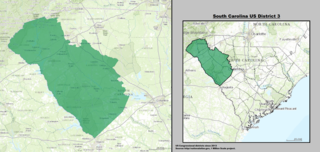
The 3rd Congressional District of South Carolina is a congressional district in western South Carolina bordering both Georgia and North Carolina. It includes all of Abbeville, Anderson, Edgefield, Greenwood, Laurens, McCormick, Oconee, Pickens and Saluda counties and portions of Greenville and Newberry counties. The district is mostly rural, but much of the economy revolves around the manufacturing centers of Anderson and Greenwood.
James Butler Hare, was elected to the U.S. House of Representatives for South Carolina's 3rd congressional district. He served for one term from 1949 to 1951.

Saluda Township is one of ten townships in Jefferson County, Indiana, United States. As of the 2010 census, its population was 1,370 and it contained 619 housing units. It was created by the Jefferson County Court of Common Pleas on Feb. 13, 1817. Saluda is derived from a Native American name meaning "river of corn".

Saluda is an unincorporated community in Saluda Township, Jefferson County, Indiana.

This is a list of the National Register of Historic Places listings in Saluda County, South Carolina.

The Saluda Mountains are a mountain range that straddles along the North Carolina and South Carolina border, in the southeastern United States. They are part of the Blue Ridge Province of the Southern Appalachian Mountains.

The 1980 United States presidential election in South Carolina took place on November 4, 1980. All fifty states and The District of Columbia were part of the 1980 United States presidential election. South Carolina voters chose eight electors to the Electoral College, who voted for president and vice president.

Saluda is an unincorporated community located in Knox County, Illinois.


