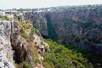
Cennet and Cehennem (English: heaven and hell) are the names of two large sinkholes in the Taurus Mountains, in Mersin Province, Turkey. The sinkholes are among the tourist attractions of the province.
Cennet and Cehennem are situated next to each other. Cennet is situated at 36°27′09″N34°6′20″E / 36.45250°N 34.10556°E and Cehennem is at 36°27′16″N34°6′21″E / 36.45444°N 34.10583°E . Both of them are in the rural area of the Silifke district which in turn is a part of Mersin Province. They are accessible by a 2 kilometres (1.2 mi) long all season open road from the main highway (D 400). The highway distances are 22 kilometres (14 mi) to Silifke and 67 kilometres (42 mi) to Mersin. They are close to the coastal town of Narlıkuyu.
The opening of Cennet is 250 x 110 m2 (820 x 360 ft2) and its average depth is 70 metres (230 ft). It is possible to reach the bottom of Cennet by a primitive staircase composed of 300 steps. In 2020 also an elevator was established. At the bottom toward the south, there is a smaller and 150 step deeper cave. In this cave are the ruins of a monastery built in the 5th century by a certain Paulus and dedicated to Virgin Mary. In this monastery one can hear the sound of a small underground stream which flows from the monastery to the gulf of Narlıkuyu. [1]
Cehennem is a deeper sinkhole with a depth of 128 metres (420 ft). But its top opening is smaller with dimensions 70 x 50 m2 ( 210 x 150 ft2 ). As the upper edge of the opening is concave there is no access to the bottom of Cehennem.
In mythology, Zeus kept Typhon temporarily in Cehennem before imprisoning him under Mount Etna.(see Corycian Cave)
Silifke is a town and district in south-central Mersin Province, Turkey, 80 km (50 mi) west of the city of Mersin, on the west end of Çukurova.
Mersin Province, formerly İçel Province, is a province in southern Turkey, on the Mediterranean coast between Antalya and Adana. The provincial capital and the biggest city in the province is Mersin, which is composed of Akdeniz, Mezitli, Toroslar and Yenişehir metropolitan municipalities, followed by Tarsus, the birthplace of Paul the Apostle. The province is considered to be a part of the geographical, economical and cultural region of Çukurova, which covers the provinces of Mersin, Adana, Osmaniye and Hatay.
Narlıkuyu is a small coastal town in Mersin Province, Turkey.
Kanlıdivane is an ancient city situated around a big sinkhole in Mersin Province, Turkey.
Adamkayalar is a location in Mersin Province, Turkey famous for rock carved figures.
Tokmar Castle is a castle ruin in Mersin Province, Turkey
Ulugöz is a village in Silifke district of Mersin Province, Turkey. It is situated on Turkish state highway D.400 which runs from west to east in south Turkey at 36°21′N33°56′E. Distance to Silifke is 4 kilometres (2.5 mi) and to Mersin is 89 kilometres (55 mi). The population of Ulugöz is 830 as of 2011. Major economic activity of the village is farming. Green house vegetables and strawberries are the main crops.
Mancınık Castle is a Hellenistic castle ruin in Mersin Province, Turkey.
Karakabaklı is an archaeological site in Mersin Province, Turkey.
Cambazlı is an archaeological site in Mersin Province, Turkey
Akhayat is a sinkhole in Mersin Province, Turkey.
Kisecik Canyon, a.k.a. Saklı Cennet, is a canyon in Mersin Province, Turkey.
Narlıkuyu Mosaic Museum is a small museum in Narlıkuyu, Turkey that encompasses a Roman bath with a mosaic tile floor. The mosaic depicts the three Graces.
Eğribük is a small Mediterranean bay with ruins in the beach, in south Turkey.
Sinekkale is the archaeological remains of a big villa rustica in Turkey. The original name is unknown.
Işıkkale is an ancient settlement in Turkey.
Çukurpınar Cave is a cave in Mersin Province, Turkey.
Hasanaliler Church is a church ruin in Mersin Province, Turkey.
Tekkadın ruins are a group of ruins in Mersin Province, Turkey. The name of the ruins is a local name meaning "single woman". The original name is not known. The ruins are in the rural area of Silifke ilçe (district) of Mersin Province at 36°29′19″N34°00′27″E. The visitors follow Turkish state highway D.400 and turn north in Atakent town. The ruins are about 11 kilometres (6.8 mi) to Atakent. Distance to Silifke is 27 kilometres (17 mi) and to Mersin is 77 kilometres (48 mi).
Wikimedia Commons has media related to Cennet ve Cehennem . |
Wikivoyage has a travel guide for Cennet and Cehennem . |