
In ecology, a marsh is a wetland that is dominated by herbaceous plants rather than by woody plants. More in general, the word can be used for any low-lying and seasonally waterlogged terrain. In Europe and in agricultural literature low-lying meadows that require draining and embanked polderlands are also referred to as marshes or marshland.

The stone pine, botanical name Pinus pinea, also known as the Italian stone pine, Mediterranean stone pine, umbrella pine and parasol pine, is a tree from the pine family (Pinaceae). The tree is native to the Mediterranean region, occurring in Southern Europe and the Levant. The species was introduced into North Africa millennia ago, and is also naturalized in the Canary Islands, South Africa and New South Wales.
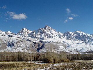
The Taurus Mountains are a mountain complex in southern Turkey, separating the Mediterranean coastal region from the central Anatolian Plateau. The system extends along a curve from Lake Eğirdir in the west to the upper reaches of the Euphrates and Tigris rivers in the east. It is a part of the Alpide belt in Eurasia.

Mersin Province, formerly İçel Province, is a province and metropolitan municipality in southern Turkey, on the Mediterranean coast between Antalya and Adana. Its area is 16,010 km2, and its population is 1,916,432 (2022). The provincial capital and the biggest city in the province is Mersin, which is composed of four municipalities and district governorates: Akdeniz, Mezitli, Toroslar and Yenişehir. Next largest is Tarsus, the birthplace of Paul the Apostle. The province is considered to be a part of the geographical, economical and cultural region of Çukurova, which covers the provinces of Mersin, Adana, Osmaniye and Hatay.

The Berdan, the ancient Cydnus, is a river in Mersin Province, south Turkey. The historical city of Tarsus is on the river and it is therefore sometimes called the Tarsus River. Originally the watercourse passed directly through the city, but the section in Tarsus was changed to its present course in the 6th century. The river is also the location of Tarsus Waterfall.
Gulf of Mersin is one of the widest gulfs in Turkey. It is in the northeast of the Mediterranean Sea between the gulfs of İskenderun and Antalya.

The forestry sector of Pakistan is a main source of lumber, paper, fuelwood, latex, medicine as well as food and provide ecotourism and wildlife conservation purposes. 5% of Pakistan's land is covered in forest (2024). The Shangla district is the only district of Pakistan that composed of more than 80% of forest land.

The Middle Atlantic coastal forests are a temperate coniferous forest mixed with patches of evergreen broadleaved forests along the coast of the southeastern United States.
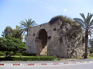
Cleopatra's Gate is a city gate of Tarsus, in Mersin Province, Turkey, named after the Egyptian (Ptolemaic) queen Cleopatra VII.
Huzurkent is a former municipality in Mersin Province, Turkey. In 2008 the municipality was abolished and absorbed into the municipality Akdeniz within the new district Akdeniz, which was created from part of the former central district of Mersin.
Halitağa is a neighbourhood in the municipality and district of Tarsus, Mersin Province, Turkey. Its population is 211 (2022). It is situated in Çukurova to the southeast of Tarsus and east of Karabucak Forest. Its distance to Tarsus is 10 kilometres (6.2 mi) and its distance to Mersin is 36 kilometres (22 mi).

The Southeastern conifer forests are a temperate coniferous forest ecoregion of the southeastern United States. It is the largest conifer forest ecoregion east of the Mississippi River. It is also the southernmost instance of temperate coniferous forest within the Nearctic realm.
Ahmet Turan Emeksiz was a Turkish university student who was killed in 1960 street demonstrations.
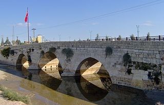
Baç Bridge is a bridge in Tarsus in Mersin Province, Turkey

Kadıncık 1 hydroelectric plant, is a privately owned hydroelectric power station located in Mersin Province, Turkey.

100th Anniversary (Gümüşkum) Nature Park is a coastal nature park in Mersin, Turkey.
Pullu I Nature Park is a coastal nature park in Anamur ilçe (district) of Mersin Province, Turkey. The index "I" is to distinguish the park from a neighboring park with the same name.
Erdemli Pine Groove is a nature park in Turkey. It is also called "Talat Göktepe Groove" to commemorate Talat Göktepe a former director of Forestry in Çanakkale who died while fighting against forest fire in 1994. It is located at 36°35′28″N34°17′10″E to the west of Erdemli ilçe (district) of Mersin Province. It lies between the Turkish state highway D.400 and the Mediterranean Sea coast.
Kuyuluk Nature Park is a nature park in Turkey.

Aydıncık Nature Park is a nature park in Turkey. It is at 36°08′52″N33°21′38″E and situated to the east of Aydıncık ilçe (district) of Mersin Province. Its distance to Aydıncık centrum is about 2 kilometres (1.2 mi) and to Mersin is about 170 kilometres (110 mi). Gilindire Cave is to the east of the nature park. It was declared a picnic area in 1988 and a nature park in 2011.