
Bayezid II was the sultan of the Ottoman Empire from 1481 to 1512. During his reign, Bayezid consolidated the Ottoman Empire, thwarted a pro-Safavid rebellion and finally abdicated his throne to his son, Selim I. Bayezid evacuated Sephardi Jews from Spain following the fall of the Nasrid Kingdom of Granada and the proclamation of the Alhambra Decree and resettled them throughout Ottoman lands, especially in Salonica.
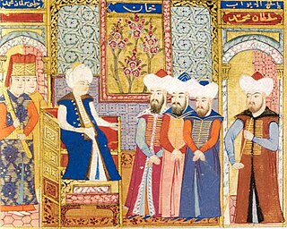
Mehmed I, also known as Mehmed Çelebi or Kirişçi, was the sultan of the Ottoman Empire from 1413 to 1421. Son of Sultan Bayezid I and his concubine Devlet Hatun, he fought with his brothers over control of the Ottoman realm in the Ottoman Interregnum (1402–1413). Starting from the province of Rûm he managed to bring first Anatolia and then the European territories (Rumelia) under his control, reuniting the Ottoman state by 1413, and ruling it until his death in 1421. Called "The Restorer," he reestablished central authority in Anatolia, and he expanded the Ottoman presence in Europe by the conquest of Wallachia in 1415. Venice destroyed his fleet off Gallipoli in 1416 as the Ottomans lost a naval war.

The Karamanids, also known as the Emirate of Karaman and Beylik of Karaman, was an Anatolian beylik of Salur tribe origin, centered in South-Central Anatolia around the present-day Karaman Province. From the mid 14th century until its fall in 1487, the Karamanid dynasty was one of the most powerful beyliks in Anatolia.

Karaman is a city in south central Turkey, located in Central Anatolia, north of the Taurus Mountains, about 100 km (62 mi) south of Konya. It is the seat of Karaman Province and Karaman District. Its population is 175,390 (2022). The town lies at an average elevation of 1,039 m (3,409 ft). The Karaman Museum is one of the major sights.

Anatolian beyliks were Turkish principalities in Anatolia governed by beys, the first of which were founded at the end of the 11th century. A second and more extensive period of establishment took place as a result of the decline of the Seljuq Sultanate of Rûm in the latter half of the 13th century.

Mersin Province, formerly İçel Province, is a province and metropolitan municipality in southern Turkey, on the Mediterranean coast between Antalya and Adana. Its area is 16,010 km2, and its population is 1,916,432 (2022). The provincial capital and the biggest city in the province is Mersin, which is composed of four municipalities and district governorates: Akdeniz, Mezitli, Toroslar and Yenişehir. Next largest is Tarsus, the birthplace of Paul the Apostle. The province is considered to be a part of the geographical, economical and cultural region of Çukurova, which covers the provinces of Mersin, Adana, Osmaniye and Hatay.

Alaiye (علائیه) is the medieval Seljuq name for Alanya. It refers to the city-state in a specific period and the beylik which developed around there, at times under the Karamanid dynasty. After the 1242 Battle of Köse Dağ, the Seljuqs lost control of the city, and it became semi-autonomous.
Ibrahim II (1400-1464) was a bey of Karaman.

Nasiraeddin Mehmed II of Karaman, also Mehmed Beg, Mehmed Beg II or Nasir al-Din Mehmed Beg was the Bey ruler of Karaman. His mother was Nefise Hatun, a daughter of Ottoman Sultan Murad I.
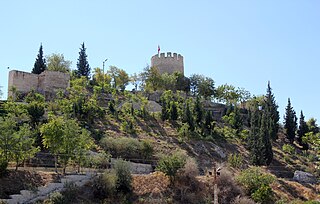
Mut Castle is a castle in Mut, Mersin Province, Turkey.
Yakub II, also known as Yakub Chelebi, was Bey of Germiyan in western Anatolia from 1387 to 1390, 1402 to 1411, and 1414 until his death. Yakub was the patron of several literary and architectural works produced during his reign.
Nûre Sûfi Bey was the founder of Karamanid dynasty, a Turkic dynasty which ruled part of Anatolia in the 14th and 15th centuries as a rival of the Ottoman Empire. He was the son of Hodja Sad al-Din who had come from Arran, staying for some years near Sivas.
Karim al-Dīn Ḳarāmān Beg was a Turkoman chieftain who ruled the Karamanids in the 13th century. Ḳarāmān Beg's emergence coincides with the defeat of the Sultanate of Rum by the Mongolian Empire in 1256 and the tension between Kaykaus I and his rival brother Kilij Arslan IV, which allowed local lords living along the boundaries of the state to exercise some autonomy.

Şah Sultan was an Ottoman princess, daughter of Sultan Selim I and one of his concubines. She was the half-sister of Sultan Suleiman the Magnificent.
In the 18th and 19th centuries, Karamania was an exonym used by Europeans for the southern (Mediterranean) coast of Anatolia, then part of the Ottoman Empire. It can also refer to the general south central Anatolian region, whose name is reflected on the modern town of Karaman. It is also the namesake of the larger Karaman Province of Turkey, the historical Karaman Eyalet of the Ottoman Empire, the medieval Turkish Karamanids dynasty and state from the region, and the Karamanlides, a Turkish-speaking Orthodox Christian group originally from the area.
Nefise Melek Sultan Hatun was an Ottoman princess, daughter of Sultan Murad I. She was the wife of Alaeddin Ali Bey of Karaman and mother of Mehmed II of Karaman and Alaeddin Ali II of Karaman. She is known as the first politically active Ottoman princess.
Suleiman Shah, also known as Shah Chelebi, was Bey of Germiyan in western Anatolia from 1361 until his death. His reign was initially peaceful, but he was eventually involved in a conflict with the Karamanids, which forced him to seek an alliance with the Ottoman state. He arranged the marriage of his daughter Devletşah Hatun and Murad I's son and future successor, Bayezid. Although he secured an alliance with the Ottomans, Germiyan lost considerable land as Suleiman left numerous towns and smaller settlements for them to seize, including the capital Kütahya, as part of the dowry payment. Suleiman relocated to Kula and died there in 1387.

Kubat Pasha Madrasa is a historic madrasa building in Tarsus district of Mersin Province, southern Turkey.
Balabolu is a hill and an archaeological site on the hill in Mersin Province, Turkey.
Taşhan is a historical caravanserai in Mersin Province, Turkey.


