Gezende Dam

Last updated
Gezende Dam

Gezende-Stausee bei Evsin, Blick nach Sudost.jpg

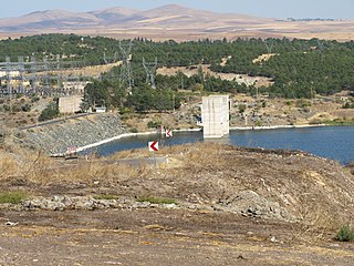
Gezende reservoir near Evsin, view to the southeast
Location Turkey
Construction began 1979
Opening date 1990
Dam and spillways
Type of dam Concrete arch
Impounds Ermenek River
Height 75 m (246 ft)
Reservoir
Total capacity 92,000,000 m3 (74,586 acre⋅ft)
Power Station
Installed capacity 159 MW
Annual generation 528 GWh

Gezende Dam is an arch dam on the Ermenek River in Mersin Province, Turkey. The development was backed by the Turkish State Hydraulic Works.

Arch dam solid dam made of concrete that is curved upstream in plan

An arch dam is a concrete dam that is curved upstream in plan. The arch dam is designed so that the force of the water against it, known as hydrostatic pressure, presses against the arch, compressing and strengthening the structure as it pushes into its foundation or abutments. An arch dam is most suitable for narrow canyons or gorges with steep walls of stable rock to support the structure and stresses. Since they are thinner than any other dam type, they require much less construction material, making them economical and practical in remote areas.

Mersin Province Province of Turkey in Mediterranean

The Mersin Province is a province in southern Turkey, on the Mediterranean coast between Antalya and Adana. The provincial capital is the city of Mersin and the other major town is Tarsus, birthplace of St Paul. The province is part of Çukurova, a geographical, economical and cultural region, that covers the provinces of Mersin, Adana, Osmaniye and Hatay.

Turkey Republic in Western Asia

Turkey, officially the Republic of Turkey, is a transcontinental country located mainly in Western Asia, with a smaller portion on the Balkan Peninsula in Southeast Europe. East Thrace, located in Europe, is separated from Anatolia by the Sea of Marmara, the Bosphorous strait and the Dardanelles. Turkey is bordered by Greece and Bulgaria to its northwest; Georgia to its northeast; Armenia, the Azerbaijani exclave of Nakhchivan and Iran to the east; and Iraq and Syria to the south. Istanbul is the largest city, but more central Ankara is the capital. Approximately 70 to 80 per cent of the country's citizens identify as Turkish. Kurds are the largest minority; the size of the Kurdish population is a subject of dispute with estimates placing the figure at anywhere from 12 to 25 per cent of the population.

Gezende reservoir near Evsin, view to the south. Gezende-Stausee bei Evsin, Blick nach Sud.jpg
Gezende reservoir near Evsin, view to the south.

See also

Related Research Articles

Cindere Dam is a gravity dam on the Büyük Menderes River in Denizli Province, Turkey. The development was backed by the Turkish State Hydraulic Works.

Çakmak Dam is a dam in Samsun Province, Turkey, built between 1985 and 1988. The development was backed by the Turkish State Hydraulic Works.

Çamlıgöze Dam dam

Çamlıgöze Dam is an embankment dam on the Kelkit River in Sivas Province, Turkey. The development was backed by the Turkish State Hydraulic Works.

Çatak Dam is a dam in Kastamonu Province, Turkey, built between 1990 and 1993. The development was backed by the Turkish State Hydraulic Works.

Çayboğazı Dam is a dam in Turkey. The development was backed by the Turkish State Hydraulic Works.

Çine Dam

Çine Dam is a dam in Turkey. The development was backed by the Turkish State Hydraulic Works. It is the first major roller compacted concrete dam in Turkey. At its height of 137 m, Cine Dam is one of the highest dams in the world.

Deliçay Dam is a dam in Turkey. The development was backed by the Turkish State Hydraulic Works.

Demirköprü Dam is an embankment dam on the Gediz River in Manisa Province, Turkey. Constructed between 1954 and 1960, the development was backed by the Turkish State Hydraulic Works. The dams supports a 69 MW power station and provides water for the irrigation of 99,220 hectares.

Gazibey Dam is a dam in Turkey. The development was backed by the Turkish State Hydraulic Works.

Germeçtepe Dam is a dam in Kastamonu Province, Turkey, built between 1977 and 1984. The development was backed by the Turkish State Hydraulic Works.

Gödet Dam is a dam in Turkey. The development was backed by the Turkish State Hydraulic Works.

Gönen Dam dam

Gönen Dam is a dam in Turkey. The development was backed by the Turkish State Hydraulic Works.

Hancağız Dam is a dam in Turkey. The development was backed by the Turkish State Hydraulic Works.

Hasanlar Dam is a dam in Düzce Province, Turkey, built between 1965 and 1972. The development was backed by the Turkish State Hydraulic Works.

Hirfanlı Dam

Hirfanlı Dam is a dam in Turkey. The development was backed by the Turkish State Hydraulic Works. It was built by Wimpey Construction and was completed in 1959.

İvriz Dam is a dam in Turkey. The development was backed by the Turkish State Hydraulic Works.

Kalecik Dam (Osmaniye) is a dam in Osmaniye Province, Turkey. The development was backed by the Turkish State Hydraulic Works.

Köprübaşı Dam is an embankment dam on the Bolu River Zonguldak Province, Turkey. The development was backed by the Turkish State Hydraulic Works.

Kulaksızlar Dam is a dam in Kastamonu Province, Turkey, built between 1993 and 2001. The development was backed by the Turkish State Hydraulic Works.

Küçükler Dam is a dam in Uşak Province, Turkey, built between 1996 and 2001. The development was backed by the Turkish State Hydraulic Works.

References

Coordinates: 36°32′02″N33°11′26″E / 36.534°N 33.1906°E / 36.534; 33.1906

Geographic coordinate system Coordinate system

A geographic coordinate system is a coordinate system that enables every location on Earth to be specified by a set of numbers, letters or symbols. The coordinates are often chosen such that one of the numbers represents a vertical position and two or three of the numbers represent a horizontal position; alternatively, a geographic position may be expressed in a combined three-dimensional Cartesian vector. A common choice of coordinates is latitude, longitude and elevation. To specify a location on a plane requires a map projection.