Mersin Province, formerly İçel Province, is a province and metropolitan municipality in southern Turkey, on the Mediterranean coast between Antalya and Adana. Its area is 16,010 km2, and its population is 1,916,432 (2022). The provincial capital and the biggest city in the province is Mersin, which is composed of four municipalities and district governorates: Akdeniz, Mezitli, Toroslar and Yenişehir. Next largest is Tarsus, the birthplace of Paul the Apostle. The province is considered to be a part of the geographical, economical and cultural region of Çukurova, which covers the provinces of Mersin, Adana, Osmaniye and Hatay.

Dana Island is a small Mediterranean island of Turkey.
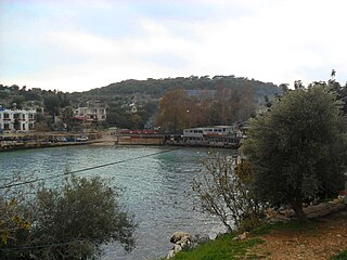
Narlıkuyu is a neighbourhood in the municipality and district of Silifke, Mersin Province, Turkey. Its population is 2,476 (2022). Before the 2013 reorganisation, it was a town (belde).
Adamkayalar is a location in Mersin Province, Turkey famous for rock carved figures.

Tokmar Castle is a castle ruin in Mersin Province, Turkey

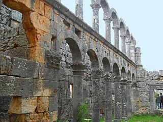
Aphrodisias, sometimes called Aphrodisias of Cilicia to distinguish it from the town of the same name in Caria, was a port city of ancient Cilicia whose ruins now lie near Cape Tisan in Mersin Province, Turkey.

Cape Tisan is a headland on the Mediterranean Sea coast of Mersin Province, Turkey. Τhe name is a distorted form of Ἀφροδισιᾶν.

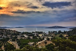
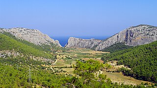
İmamuşağı is a neighbourhood in the municipality and district of Silifke, Mersin Province, Turkey. Its population is 634 (2022). The village is situated in the southern slopes of Toros Mountains. Its distance to Silifke is 20 kilometres (12 mi) and to Mersin is 105 kilometres (65 mi). Main economic activities of the village are farming and animal breeding. Olive and locust are the main crops. İmamuşağı is a mountain village. But it is a dispersed settlement and one of its neighbourhoods named Boğsak is at the sea side. A hamlet, it is a popular seaside resort for Mersin residents. There are also beaches and historical castles around Boğsak.
Cambazlı is an archaeological site in Mersin Province, Turkey

The Boğsak Tunnel is a road tunnel located in Silifke, Mersin Province in southern Turkey as part of the highway D.400.

Meydankale is the archaeological site of a ruined castle in Mersin Province, Turkey.

Narlıkuyu Mosaic Museum is a small museum in Narlıkuyu, Turkey that encompasses a Roman bath with a mosaic tile floor. The mosaic depicts the Three Graces.

Babadıl Islands are two small Mediterranean islands in Turkey. They are named after the former name of the village Sipahili in the mainland facing the islands. According to the British captain Francis Beaufort who was tasked to map the Mediterranean coasts of Turkey in 1811–12, the names of the islands were Papadoulae, in the antiquity. Modern scholarship identifies the island group with Akonesiai, and the northern island with ancient Crambusa or Krambousa (Κράμβουσα).
Güvercin Islet is a Mediterranean islet of Turkey. It is a part of Silifke ilçe (district) of Mersin Province. It is at 36°14′38″N33°48′38″E and situated about 200 metres (660 ft) to main land. The islet is quite small; only 3,000 square metres (32,000 sq ft). There are ruins of late Roman Empire era in this otherwise unnotable island. The ruins are in the north east side of the island. The ruins probably belonged to a mansion. The construction material is rectangular stone. There are tombs, ceramics and a part of a mosaic floor in the island.
Eğribük is a small Mediterranean bay with ruins in the beach, in south Turkey.

Yılanlı Ada is a small Mediterranean island in Turkey.

Saplı Islet is a Mediterranean tombolo of Turkey. The island is at the Yenikaş coast which is located 4 kilometres (2.5 mi) west of Aydıncık ilçe (district) of Mersin Province. At 36°07′48″N33°17′41″E it forms the west wall of the bay named Soğuksu. Its distance to Mersin is about 177 kilometres (110 mi)

Aydıncık Nature Park is a nature park in Turkey. It is at 36°08′52″N33°21′38″E and situated to the east of Aydıncık ilçe (district) of Mersin Province. Its distance to Aydıncık centrum is about 2 kilometres (1.2 mi) and to Mersin is about 170 kilometres (110 mi). Gilindire Cave is to the east of the nature park. It was declared a picnic area in 1988 and a nature park in 2011.

Işıkkale is an ancient settlement in Turkey.
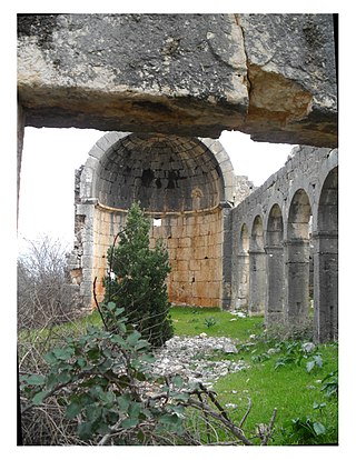
Hasanaliler Church is a church ruin in Mersin Province, Turkey.