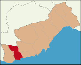
Anamur is a municipality and district of Mersin Province, Turkey. Its area is 1,430 km2, and its population is 66,846 (2022). It is the westernmost district of that province, bordering on Antalya Province. Anamur contains Anatolia's southernmost point, It is a coastal resort known for its bananas and peanuts.

Gazipaşa is a municipality and district of Antalya Province, Turkey. Its area is 1,111 km2, and its population is 53,702 (2022). It is situated on the Mediterranean coast, 180 km east of the city of Antalya. Gazipaşa is a quiet rural district famous for its bananas and oranges. Gazipaşa district is adjacent to Alanya to the northwest, Sarıveliler to the north, Anamur to the east, and the Mediterranean Sea to the west.

Kemer is a seaside resort, municipality and district of Antalya Province, Turkey. Its area is 412 km2, and its population is 49,383 (2022). It is on the Mediterranean coast, 43 km (27 mi) west of the city of Antalya, on the Turkish Riviera.

Mersin Province, formerly İçel Province, is a province in southern Turkey, on the Mediterranean coast between Antalya and Adana. The provincial capital and the biggest city in the province is Mersin, which is composed of four municipalities and district governorates: Akdeniz, Mezitli, Toroslar and Yenişehir. Next largest is Tarsus, the birthplace of Paul the Apostle. The province is considered to be a part of the geographical, economical and cultural region of Çukurova, which covers the provinces of Mersin, Adana, Osmaniye and Hatay.

Koçarlı is a municipality and district of Aydın Province, Turkey. Its area is 455 km2, and its population is 21,832 (2022). It is 24 km (15 mi) from the city of Aydın.
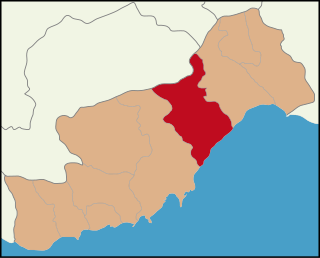
Erdemli is a municipality and district of Mersin Province, Turkey. Its area is 2,279 km2, and its population is 151,928 (2022). It is 35 km (22 mi) west of the city of Mersin.

Finike, the ancient Phoenix or Phoinix, also formerly Phineka, is a municipality and district of Antalya Province, Turkey. Its area is 768 km2, and its population is 49,720 (2022). It lies on the Mediterranean coast of Antalya Province in Turkey, to the west of the city of Antalya, along the Turkish Riviera. It is located on the southern shore of the Teke peninsula, and the coast here is a popular tourist destination. However, Finike is best known for its oranges, the symbol of the town.

Gündoğmuş is a municipality and district of Antalya Province, Turkey. Its area is 1,175 km2, and its population is 7,188 (2022). It is 182 km from the city of Antalya, off the road from Akseki to Manavgat.

Karaisalı is a municipality and district of Adana Province, Turkey. Its area is 1,165 km2, and its population is 22,042 (2022).

Pozantı is a municipality and district of Adana Province, Turkey. Its area is 899 km2, and its population is 19,852 (2022). The town is in the highlands of Çukurova, and is a major gateway to the Mediterranean coasts. Pozantı stands in the foothills, at the bottom of one of the few passes through the mountains. The mayor is Mustafa Çay (MHP).

Demre is a municipality and district of Antalya Province, Turkey. Its area is 329 km2, and its population is 27,691 (2022). It was named after the river Demre.

Yenişehir is a municipality and district of Mersin Province, Turkey. Its area is 139 km2, and its population is 278,961 (2022). It covers the west-central part of the city of Mersin and the adjacent countryside.

Mezitli is a municipality and district of Mersin Province, Turkey. Its area is 371 km2, and its population is 222,436 (2022). It covers the westernmost part of the city of Mersin and the adjacent countryside. The Mayor of Mezitli is Neşet Tarhan.

Toroslar is a municipality and district of Mersin Province, Turkey. Its area is 1,075 km2, and its population is 319,711 (2022). It covers the northern part of the city of Mersin and the adjacent countryside.
Tekmen is a neighbourhood in the municipality and district of Bozyazı, Mersin Province, Turkey. Its population is 2,913 (2022). Before the 2013 reorganisation, it was a town (belde).

Tırtar is a neighbourhood in the municipality and district of Erdemli, Mersin Province, Turkey. Its population is 2,733 (2022). Before the 2013 reorganisation, it was a town (belde).
Tekeli is a neighbourhood in the municipality and district of Bozyazı, Mersin Province, Turkey. Its population is 3,127 (2022). Before the 2013 reorganisation, it was a town (belde).
Elmakuzu is a neighbourhood in the municipality and district of Bozyazı, Mersin Province, Turkey. Its population is 287 (2022). It is situated in Toros Mountains to the north of Bozyazı. The village is far from the main roads. The distance to Bozyazı is 42 kilometres (26 mi) and to Mersin is 241 kilometres (150 mi).
Bozyazı Island is a small Mediterranean island in Turkey.
Kızılliman is a Mediterranean headland in Turkey known for the ruins of ancient stone quarry Melenie.